1900s (20th Century) Maps of Citrus County, Florida
Explore 36 historic maps of Citrus County from the 1900s (20th Century). These maps offer a rare glimpse into what life looked like during the 1900s — showing old roads, neighborhoods, homes, and landmarks that have changed or disappeared over time.
Whether you're researching your family's past, planning a metal detecting trip, or studying how Citrus County's landscape evolved across the 1900s, these high-resolution maps are a powerful tool for exploring the history of this region.
- Focus on a specific era: All maps on this page are from the 1900s, giving you a focused view of this time period.
- See what’s changed: Compare century-old streets, trails, and buildings to today's modern landscape using overlays and satellite layers.
- Research with precision: Use these maps for genealogy, historical research, land use analysis, or educational projects.
- View, download, or print: Maps are fully viewable online in high resolution, and can be downloaded or printed for your own records.
Start exploring Citrus County's history through authentic maps from the 1900s. This is your window into the past.
Citrus County, FL maps
(36)- 1954 Map of Lecanto
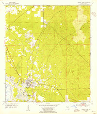
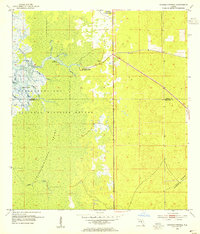
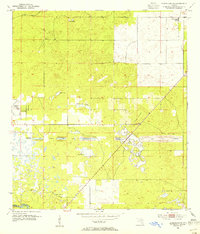
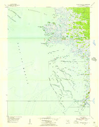
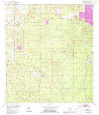 1954 Lecanto1954 Print · USGSLecanto and the surrounding Citrus County backcountry are captured in this mid-century survey, just as local industry and settlement began to shift. Researchers can trace early mining sites like Holder Mine or locate rural landmarks such as Landrum, Mansfield Pond, and Bull Sink.5 unique versions available
 - 1954 Map of Homosassa, 1955 Print
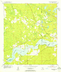
 1954 Homosassa1955 Print · USGSThe Citrus County coastline and the spring-fed Homosassa River are captured here in the mid-fifties. Researchers can locate the Stage Stand Cem, trace the Old Railroad Grade, and see the early West Citrus County Landing Field.4 unique versions available
 - 1954 Map of Holder, 1955 Print
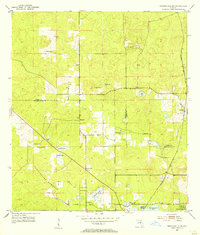
 1954 Holder1955 Print · USGSPhosphate mining and dual rail lines define this Citrus County landscape in the mid-1950s. Researchers can trace the industrial corridor from Holder to Hernando, locating numerous Mine sites and the rural Burk Cem.3 unique versions available
 - 1954 Map of Chassahowitzka Bay, 1955 Print
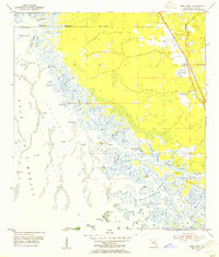
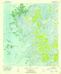
 1954 Chassahowitzka Bay1955 Print · USGSThe Florida Gulf Coast in the mid-fifties reveals an intricate wilderness of tidal creeks and limestone islands. Researchers can navigate the complex labyrinth of the Chassahowitzka National Wildlife Refuge, tracing features like Seven Cabbage Island and Chub Creek.4 unique versions available
 - 1954 Map of Crystal River, 1955 Print
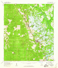
 1954 Crystal River1955 Print · USGSCrystal River and its spring-fed tributaries are captured here in the mid-fifties, showing a coastal landscape shaped by rail and water. Researchers can trace the town's early grid, the Atlantic Coast Line railroad, and landmarks like Hunter Spring or Citronelle.3 unique versions available
 - 1954 Map of Brooksville NW, 1955 Print
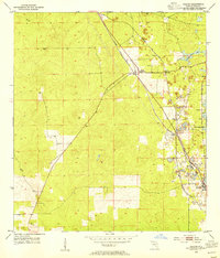
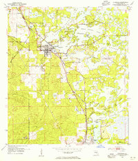
 1954 Brooksville NW1955 Print · USGSFlorida's Nature Coast transition in the 1950s is detailed here along the Citrus and Hernando county line. Genealogists and researchers can trace rural life through landmarks like Stage Pond Cem, Hebron Ch, and the Stafford Siding rail stop.4 unique versions available
 - 1954 Map of Nobleton, 1955 Print
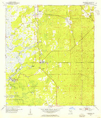
 1954 Nobleton1955 Print · USGSThe Citrus and Hernando county line comes alive in the mid-fifties, showing a landscape shaped by the phosphate industry and the Withlacoochee River. Genealogists can locate family landmarks like Frazier Cem and the Story Mine near Floral City.3 unique versions available
 - 1954 Map of Tsala Apopka NE, 1955 Print
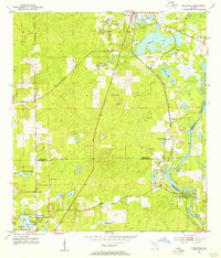
 1954 Tsala Apopka NE1955 Print · USGSMid-century Citrus County is defined here by the intricate wetlands and rail lines that once fueled the local economy. Genealogists and historians can trace the foundations of Hernando and locate rural landmarks like Stokes Ferry and Twomile Prairie Lake.5 unique versions available
 - 1954 Map of Chassahowitzka, 1955 Print
 1954 Chassahowitzka1955 Print · USGSCoastal Florida's Nature Coast is captured in the mid-fifties, showing the intersection of dense hammock lands and sprawling tidal marshes. Trace the original footprints of Chassahowitzka and navigate the intricate waters of the Chassahowitzka River and Blind Creek.4 unique versions available
 - 1954 Map of Dunnellon, 1955 Print
 1954 Dunnellon1955 Print · USGSDunnellon and the surrounding phosphate mining district come into sharp focus in the mid-1950s. Trace the rail-and-river history of the region through the Atlantic Coast Line, the Rockwell Cem, and the Dunnellon Airport (Abandoned).3 unique versions available
 - 1954 Map of Red Level, 1955 Print
 1954 Red Level1955 Print · USGSCoastal Citrus County in the mid-fifties is captured here as a labyrinth of tidal creeks and phosphate mines near the Gulf of Mexico. Genealogists and historians can locate Red Level Cem, Mt Olive Ch, and ancient landmarks like the Indian Mound along the Crystal River.5 unique versions available
 - 1954 Map of Inverness, 1955 Print
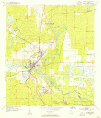
 1954 Inverness1955 Print · USGSInverness and Floral City are captured in the mid-fifties at the edge of the sprawling Tsala Apopka Lake system. Genealogists and local historians can trace the paths of the Seaboard Air Line, locate the Hill of Rest Cem, or find the Poor Farm Landing Field.4 unique versions available
 - 1954 Map of Dunnellon SE, 1955 Print
 1954 Dunnellon SE1955 Print · USGSMarion County in the mid-1950s reveals the interrupted dream of a trans-Florida waterway. Researchers can trace the path of the Proposed Gulf Atlantic Ship Canal (Abandoned) and locate landmarks like Cedar Grove Ch and the Dunnellon Airport (Abandoned).2 unique versions available
 - 1954 Map of Yankeetown SE, 1955 Print
 1954 Yankeetown SE1955 Print · USGSThe Florida hammock country comes into focus in the mid-1950s as the Withlacoochee River flows through the convergence of three counties. You can trace the Atlantic Coast Line rail route and locate secluded landmarks like Lebanon Cem and Dog Ear Cem.3 unique versions available
 - 1954 Map of Ozello, 1955 Print
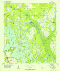
 1954 Ozello1955 Print · USGSThe Citrus County coastline was a maze of mangrove islands and tidal creeks in the mid-fifties, centered on the remote village of Ozello. Local historians can trace the intricate waterways of the St Martins River, find old landmarks like Hell Gate, and explore the early boundaries of the Chassahowitzka National Wildlife Refuge.5 unique versions available
 - 1954 Map of Inverness, 1960 Print
 1954 Inverness1960 Print · USGSMid-century Citrus County is defined by the intricate wetlands and island communities of the lake region. Genealogists and historians can trace the paths of the Atlantic Coast Line through Hernando or locate the Dampier Cemetery and the Poor Farm Landing Field.2 unique versions available
 - 1954 Map of Dunnellon, 1960 Print
 1954 Dunnellon1960 Print · USGSDunnellon and rural Marion County appear in the mid-1950s as a landscape of phosphate mining, railroads, and fresh water springs. Genealogists and historians can trace family locations near Zion Hill Cem, Cotton Plant, and the Circle Square Ranch.
 - 1954 Map of Gainesville, 1965 Print
 1954 Gainesville1965 Print · USGSMid-century North Central Florida comes into focus as a landscape of timber, rails, and river towns along the Gulf. Trace family roots in established centers like Gainesville or follow the path of the Suwannee River to the coastal docks of Cedar Key.3 unique versions available
 - 1955 Map of Withlacoochee Bay, 1956 Print
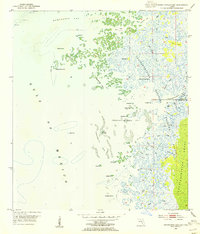
 1955 Withlacoochee Bay1956 Print · USGSThe Florida Gulf Coast in the mid-fifties was a wild network of tidal creeks and oyster bars. Local historians and boaters can trace the intricate channels of Port Inglis, Bungalow Pass, and family landmarks like Pitts Camp or Deadman Key.4 unique versions available
 - 1955 Map of Yankeetown, 1956 Print
 1955 Yankeetown1956 Print · USGSThe coastal wetlands of Levy County are mapped here in the mid-1950s, showing the early development of the riverfront. You can trace the community layouts of Yankeetown and Inglis alongside family landmarks like Priest Cem and Botts Field.5 unique versions available
 - 1955 Map of Plant City, 1966 Print
 1955 Plant City1966 Print · USGSMid-century Central Florida comes to life in this survey of the Nature Coast and the inland citrus and rail belt. Genealogists and historians can trace the paths of the Atlantic Coast Line, locate the Anclote Keys Lighthouse, or find old communities like Masaryktown and Lacoochee.6 unique versions available
 - 1958 Map of Plant City
 1958 Plant City1958 Print · USGSFlorida's Gulf Coast and inland ridge country are captured here in the mid-fifties, showing the region before modern sprawl. Genealogists and historians can trace rail-era towns like Richland and Trilby or locate coastal landmarks such as the Anclote Keys Lighthouse.
 - 1958 Map of Gainesville
 1958 Gainesville1958 Print · USGSNorth Central Florida’s rail and river networks are frozen in time just before the interstate era. Genealogists and historians can trace the paths of the Atlantic Coast Line through Gainesville or locate coastal settlements like Steinhatchee and Cedar Key.
 - 1958 Map of Wahoo, 1960 Print
 1958 Wahoo1960 Print · USGSSumter County was a landscape of intricate wetlands and rail-line settlements during the late fifties. Researchers can trace the proximity of Wahoo to the Seaboard railroad or locate historic sites like Dade Battlefield Memorial State Park and Pleasant Hill Ch.2 unique versions available
 - 1959 Map of Plant City
 1959 Plant City1959 Print · USGSThe West Florida coast and inland timberlands are captured here in the late fifties, from the bend of the Gulf to the rail hubs of the interior. Trace the paths of the Atlantic Coast Line through Inverness and find landmarks like the Anclote Keys Lighthouse.
Showing maps 1-25 of 36
Top cities of Citrus County
- Homosassa Springs historical maps
- Sugarmill Woods historical maps
- Pine Ridge historical maps
- Beverly Hills historical maps
- Citrus Hills historical maps
- Hernando historical maps
See more
Frequently asked questions
- What are the different types of historical maps available for Citrus County?
- What is the oldest map of Citrus County?
- Where can I purchase historical maps of Citrus County for my home or office?
- Where can I download high-res historical maps of Citrus County?
- Are there historical topographic maps available for Citrus County?
- Is there historical aerial imagery available for Citrus County?
- Where are historical maps of Citrus County sourced from?