1990s Maps of Citrus County, Florida
Explore 5 historic maps of Citrus County from the 1990s. These maps offer a rare glimpse into what life looked like during the 1990s — showing old roads, neighborhoods, homes, and landmarks that have changed or disappeared over time.
Whether you're researching your family's past, planning a metal detecting trip, or studying how Citrus County's landscape evolved across the 1990s, these high-resolution maps are a powerful tool for exploring the history of this region.
- Focus on a specific era: All maps on this page are from the 1990s, giving you a focused view of this time period.
- See what’s changed: Compare century-old streets, trails, and buildings to today's modern landscape using overlays and satellite layers.
- Research with precision: Use these maps for genealogy, historical research, land use analysis, or educational projects.
- View, download, or print: Maps are fully viewable online in high resolution, and can be downloaded or printed for your own records.
Start exploring Citrus County's history through authentic maps from the 1990s. This is your window into the past.
Citrus County, FL maps
(5)- 1991 Map of Dunnellon SE
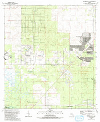 1991 Dunnellon SE1991 Print · USGSMarion County enters a decade of rapid transformation in the early nineties as residential communities expand across the landscape. Genealogists and historians can trace the growth of Oak Run and Marion Oaks alongside rural landmarks like Cedar Grove Ch.
 - 1991 Map of Dunnellon
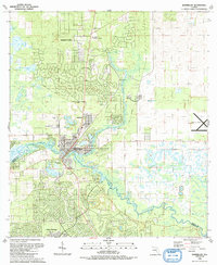 1991 Dunnellon1991 Print · USGSDunnellon and the surrounding river country are captured here in the early nineties as suburban expansion began to meet the Florida wilderness. Genealogists can trace family names at Rockwell Cem or locate historic congregations like Beulah Ch and New Second Bethel Ch.
 - 1991 Map of Yankeetown SE
 1991 Yankeetown SE1991 Print · USGSIn the early 1990s, this area of Levy and Citrus counties showed a landscape shaped by water management and emerging residential tracts. Trace the engineering of the Barge Canal and Inglis Lock, or locate rural burial sites like Robinson Cem and Dog Ear Cem.
 - 1994 Map of Chassahowitzka Bay, 1998 Print
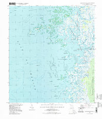 1994 Chassahowitzka Bay1998 Print · USGSThe Florida Gulf Coast near the Citrus and Hernando county line is shown here in the mid-1990s, dominated by a labyrinth of islands and tidal marshes. Trace the winding paths of Chassahowitzka River past Johns Island and into the Chassahowitzka Reefs.
 - 1994 Map of Ozello, 1998 Print
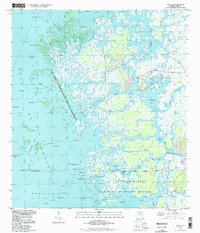 1994 Ozello1998 Print · USGSThe Florida coast near Citrus County comes alive in this mid-nineties survey of the sawgrass marshes and winding tidal creeks. Boaters and local historians can trace the intricate passages of The Narrows, find the isolated community of Ozello, and locate landmarks like Hell Gate and Paradise I.
End of results
Showing maps 1-5 of 5
Top cities of Citrus County
- Homosassa Springs historical maps
- Sugarmill Woods historical maps
- Pine Ridge historical maps
- Beverly Hills historical maps
- Citrus Hills historical maps
- Hernando historical maps
See more
Frequently asked questions
- What are the different types of historical maps available for Citrus County?
- What is the oldest map of Citrus County?
- Where can I purchase historical maps of Citrus County for my home or office?
- Where can I download high-res historical maps of Citrus County?
- Are there historical topographic maps available for Citrus County?
- Is there historical aerial imagery available for Citrus County?
- Where are historical maps of Citrus County sourced from?