1950s Maps of Crystal River, Florida
Explore 6 historic maps of Crystal River from the 1950s. These maps offer a rare glimpse into what life looked like during the 1950s — showing old roads, neighborhoods, homes, and landmarks that have changed or disappeared over time.
Whether you're researching your family's past, planning a metal detecting trip, or studying how Crystal River's landscape evolved across the 1950s, these high-resolution maps are a powerful tool for exploring the history of this region.
- Focus on a specific era: All maps on this page are from the 1950s, giving you a focused view of this time period.
- See what’s changed: Compare century-old streets, trails, and buildings to today's modern landscape using overlays and satellite layers.
- Research with precision: Use these maps for genealogy, historical research, land use analysis, or educational projects.
- View, download, or print: Maps are fully viewable online in high resolution, and can be downloaded or printed for your own records.
Start exploring Crystal River's history through authentic maps from the 1950s. This is your window into the past.
Crystal River, FL maps
(6)- 1954 Map of Homosassa, 1955 Print
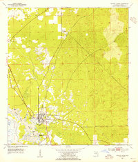
 1954 Homosassa1955 Print · USGSThe Citrus County coastline and the spring-fed Homosassa River are captured here in the mid-fifties. Researchers can locate the Stage Stand Cem, trace the Old Railroad Grade, and see the early West Citrus County Landing Field.4 unique versions available
 - 1954 Map of Crystal River, 1955 Print
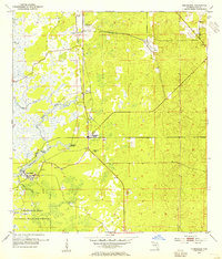
 1954 Crystal River1955 Print · USGSCrystal River and its spring-fed tributaries are captured here in the mid-fifties, showing a coastal landscape shaped by rail and water. Researchers can trace the town's early grid, the Atlantic Coast Line railroad, and landmarks like Hunter Spring or Citronelle.3 unique versions available
 - 1954 Map of Red Level, 1955 Print
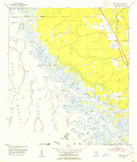 1954 Red Level1955 Print · USGSCoastal Citrus County in the mid-fifties is captured here as a labyrinth of tidal creeks and phosphate mines near the Gulf of Mexico. Genealogists and historians can locate Red Level Cem, Mt Olive Ch, and ancient landmarks like the Indian Mound along the Crystal River.5 unique versions available
 - 1955 Map of Plant City, 1966 Print
 1955 Plant City1966 Print · USGSMid-century Central Florida comes to life in this survey of the Nature Coast and the inland citrus and rail belt. Genealogists and historians can trace the paths of the Atlantic Coast Line, locate the Anclote Keys Lighthouse, or find old communities like Masaryktown and Lacoochee.6 unique versions available
 - 1958 Map of Plant City
 1958 Plant City1958 Print · USGSFlorida's Gulf Coast and inland ridge country are captured here in the mid-fifties, showing the region before modern sprawl. Genealogists and historians can trace rail-era towns like Richland and Trilby or locate coastal landmarks such as the Anclote Keys Lighthouse.
 - 1959 Map of Plant City
 1959 Plant City1959 Print · USGSThe West Florida coast and inland timberlands are captured here in the late fifties, from the bend of the Gulf to the rail hubs of the interior. Trace the paths of the Atlantic Coast Line through Inverness and find landmarks like the Anclote Keys Lighthouse.
End of results
Showing maps 1-6 of 6
Top cities near Crystal River
- Homosassa Springs historical maps
- Sugarmill Woods historical maps
- Pine Ridge historical maps
- Beverly Hills historical maps
- Citrus Hills historical maps
- Lecanto historical maps
See more
Top neighborhoods of Crystal River
Frequently asked questions
- What are the different types of historical maps available for Crystal River?
- What is the oldest map of Crystal River?
- Where can I purchase historical maps of Crystal River for my home or office?
- Where can I download high-res historical maps of Crystal River?
- Are there historical topographic maps available for Crystal River?
- Is there historical aerial imagery available for Crystal River?
- Where are historical maps of Crystal River sourced from?