1900s (20th Century) Maps of Clay County, Florida
Explore 81 historic maps of Clay County from the 1900s (20th Century). These maps offer a rare glimpse into what life looked like during the 1900s — showing old roads, neighborhoods, homes, and landmarks that have changed or disappeared over time.
Whether you're researching your family's past, planning a metal detecting trip, or studying how Clay County's landscape evolved across the 1900s, these high-resolution maps are a powerful tool for exploring the history of this region.
- Focus on a specific era: All maps on this page are from the 1900s, giving you a focused view of this time period.
- See what’s changed: Compare century-old streets, trails, and buildings to today's modern landscape using overlays and satellite layers.
- Research with precision: Use these maps for genealogy, historical research, land use analysis, or educational projects.
- View, download, or print: Maps are fully viewable online in high resolution, and can be downloaded or printed for your own records.
Start exploring Clay County's history through authentic maps from the 1900s. This is your window into the past.
Clay County, FL maps
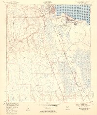
(81)- 1915 Map of Interlachen
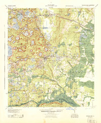
 1915 Interlachen1915 Print · USGSThe Florida interior around the lake-heavy Putnam and Marion county lines is shown here in the years before widespread drainage and development. Researchers can trace the early rail stops at Florahome and Mannville or locate rural landmarks like Magnolia Church and the Cedar Landing Ferry.
 - 1916 Map of Interlachen
 1916 Interlachen1916 Print · USGSFlorida's lake-filled interior at the start of the Great War is a landscape of scattered rail towns and expansive wetlands. Genealogists and local historians can trace family roots through old settlements like Interlachen, Putnam Hall, and Kenwood Heights, or locate the rural Roscola School and Conch School.6 unique versions available
 - 1917 Map of Orange Park, 1957 Print
 1917 Orange Park1957 Print · USGSThe St. Johns River corridor comes to life in this early twentieth-century survey of the riverbanks between Jacksonville and Green Cove Springs. Genealogists can trace family footprints through rural sites like Swimming Pen School, Hibernia, and the Durbin P.O. long before suburban sprawl.
 - 1918 Map of Middleburg
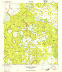
 1918 Middleburg1918 Print · USGSClay County near the end of the Great War reveals a landscape of isolated settlements and vital creek crossings. Genealogists and historians can trace the foundations of local communities through the locations of Rideout Ferry, Black Creek Church, and several namesake institutions like the Bell School.4 unique versions available
 - 1918 Map of Lawtey
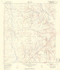
 1918 Lawtey1918 Print · USGSFlorida's northern interior during the First World War reveals a landscape of isolated farmsteads and growing rail towns. Researchers can locate early schoolhouses like Ben Rowe School and Vanderbilt School or trace the early footprint of the Bradford Farms (State Prison).5 unique versions available
 - 1918 Map of Orange Park
 1918 Orange Park1918 Print · USGSThe St. Johns River corridor comes to life in the years following the Great War, showing the transition from riverine commerce to early rail and road networks. Genealogists can locate family landmarks like Neals Dock, Bethel Church, and the Deep Bottom School across three counties.5 unique versions available
 - 1938 Map of Hawthorn
 1938 Hawthorn1938 Print · USGSAlachua County in the late thirties is a landscape of intersecting railroads and sprawling lakeside settlements. Genealogists and historians can trace the foundations of Hawthorn, locate remote burial sites like Riley Cem, and explore the rail junctions at Micanopy Junction.
 - 1941 Map of Starke, 1942 Print
 1941 Starke1942 Print · USGSNorth Florida at the start of the 1940s reveals a region rapidly transforming with the mobilization for war. Genealogists and historians can trace old rail lines like the Seaboard Air Line and find communities like Sampson City or the expansive Camp Blanding Military Reservation.
 - 1941 Map of Middleburg, 1943 Print
 1941 Middleburg1943 Print · USGSClay County at the dawn of the motorized era reveals a landscape of ferry crossings and rural schoolhouses connected by early roads. Researchers can trace the legacy of the Middleburg area through sites like the Rideout Ferry, Black Creek Church, and several named family schools.
 - 1942 Map of Ates Creek
 1942 Ates Creek1942 Print · USGSNorthern Florida's training grounds and rural settlements come into focus during the early mobilization of the Second World War. Researchers can trace the military layout of Camp Blanding alongside the agricultural colony at Penney Farms and the springs of Gold Head Branch.
 - 1943 Map of Hawthorn, 1963 Print
 1943 Hawthorn1963 Print · USGSAlachua County during the early war years reveals a landscape defined by its great lakes and a dual-railroad economy. Researchers can trace the routes of the Seaboard Air Line, locate rural landmarks like Ochwilla Church, or find family roots at Providence Cem and Drummond Cem.
 - 1944 Map of Interlachen
 1944 Interlachen1944 Print · USGSNorth-central Florida's rail-and-water network is captured here in the 1940s, centered on the bustling junction at Interlachen. Genealogists and historians can trace riverside activity at Cedar Landing Ferry and early rural education sites like Congo Sch.
 - 1947 Map of Bostwick
 1947 Bostwick1947 Print · USGSThe Saint Johns River valley in the late 1940s reveals a landscape defined by its waterways and timber-era rail lines. Researchers can trace historic river access at Clay Landing and Picolata, or follow the Atlantic Coast Line through Bostwick.
 - 1948 Map of Starke
 1948 Starke1948 Print · USGSThe Florida lake country south of Starke is captured here shortly after the war, showing a landscape defined by citrus-era rail lines and massive military training grounds. Genealogists can trace family roots through settlements like Sampson City, Waldo, and the lakeside community of Keystone Heights.
 - 1948 Map of Jacksonville
 1948 Jacksonville1948 Print · USGSNortheast Florida and Southeast Georgia's coastal waterways and railroad towns are captured here in the years following the war. Genealogists can trace family connections through river towns like St Marys or identify long-standing military landmarks like Jacksonville NAS.
 - 1949 Map of Rice Creek, 1953 Print
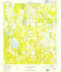 1949 Rice Creek1953 Print · USGSIn the late 1940s, the borderlands between Clay and Putnam Counties remained a dense mosaic of wetlands and winding waterways. Researchers can trace the pristine hydrology of the region through Georges Lake and the paths of Etonia Creek and Rice Creek.3 unique versions available
 - 1949 Map of Bostwick, 1953 Print
 1949 Bostwick1953 Print · USGSNorthern Putnam County's rural landscape is captured here in the late forties, showing the region's timber and rail-based settlement pattern. Genealogists can trace family locations near Sun Garden, Hancock, and De Coy Ch, or locate the old Bostwick Airport.5 unique versions available
 - 1949 Map of Middleburg SW, 1953 Print
 1949 Middleburg SW1953 Print · USGSClay County in the late 1940s is characterized by its winding creek basins and nascent military training grounds. Genealogists and researchers can trace local landmarks like Oak Grove Ch, a rural Cem, and the footprint of a Machine Gun Range.5 unique versions available
 - 1949 Map of Green Cove Springs, 1953 Print
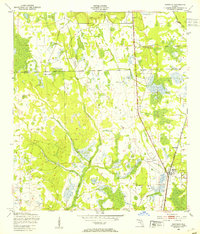
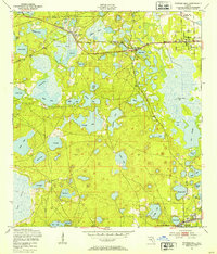
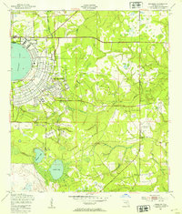
 1949 Green Cove Springs1953 Print · USGSGreen Cove Springs sits at a post-war crossroads where military installations and river life meet. Genealogists and historians can trace the footprint of the U S Naval Station alongside local landmarks like Hickory Grove Ch and Walkill.5 unique versions available
 - 1949 Map of Fiftone, 1953 Print
 1949 Fiftone1953 Print · USGSThe rural border of Duval and Clay Counties appears here just after the war, where military expansion met traditional Florida timber and rail lands. Genealogists can locate family landmarks like Mt Zion Ch and Long Branch Ch or trace the early footprint of the Cecil Naval Auxiliary Air Station.2 unique versions available
 - 1949 Map of Gold Head Branch, 1953 Print
 1949 Gold Head Branch1953 Print · USGSThe solution-lake country of North Florida is captured here just after the war, showing the intersection of rural life and state-protected wilderness. Researchers can trace the boundaries of Gold Head Branch State Park or locate the Cadero Ch and the Mobile Target Range.3 unique versions available
 - 1949 Map of Putnam Hall, 1953 Print
 1949 Putnam Hall1953 Print · USGSThe lake-strewn interior of Putnam and Clay counties is captured here in the late 1940s, highlighting a landscape of rail-connected settlements. Genealogists and researchers can trace old trackside communities like Florahome, Putnam Hall, and Grandin along the Southern railroad line.3 unique versions available
 - 1949 Map of Starke, 1953 Print
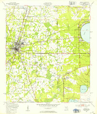 1949 Starke1953 Print · USGSStarke and the surrounding Florida pine lands are captured here just after the war, showing the area's transition between agricultural life and new industrial and military uses. Genealogists and local historians can trace rural congregations at Bethel Ch and Nebo Ch or locate the early workings of the Trail Ridge Mine.4 unique versions available
 - 1949 Map of Kingsley, 1953 Print
 1949 Kingsley1953 Print · USGSClay County's interior is defined by military and naval operations in the years following the war. Researchers can trace the extensive grounds of Camp Blanding, the circular shore of Kingsley Lake, and the remote Belmore Air Field U S Navy.3 unique versions available
 - 1949 Map of Middleburg, 1953 Print
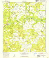 1949 Middleburg1953 Print · USGSMiddleburg and the forks of Black Creek are captured here in the late Forties, showing a landscape of river ferries and rural airfields. Genealogists can locate family landmarks like Black Pond Ch or trace the Atlantic Coast Line near the abandoned kilns at Doctors Inlet.5 unique versions available
Showing maps 1-25 of 81
Top cities of Clay County
- Middleburg historical maps
- Orange Park historical maps
- Green Cove Springs historical maps
- Keystone Heights historical maps
- Penney Farms historical maps
Frequently asked questions
- What are the different types of historical maps available for Clay County?
- What is the oldest map of Clay County?
- Where can I purchase historical maps of Clay County for my home or office?
- Where can I download high-res historical maps of Clay County?
- Are there historical topographic maps available for Clay County?
- Is there historical aerial imagery available for Clay County?
- Where are historical maps of Clay County sourced from?