1960s Maps of Clay County, Florida
Explore 5 historic maps of Clay County from the 1960s. These maps offer a rare glimpse into what life looked like during the 1960s — showing old roads, neighborhoods, homes, and landmarks that have changed or disappeared over time.
Whether you're researching your family's past, planning a metal detecting trip, or studying how Clay County's landscape evolved across the 1960s, these high-resolution maps are a powerful tool for exploring the history of this region.
- Focus on a specific era: All maps on this page are from the 1960s, giving you a focused view of this time period.
- See what’s changed: Compare century-old streets, trails, and buildings to today's modern landscape using overlays and satellite layers.
- Research with precision: Use these maps for genealogy, historical research, land use analysis, or educational projects.
- View, download, or print: Maps are fully viewable online in high resolution, and can be downloaded or printed for your own records.
Start exploring Clay County's history through authentic maps from the 1960s. This is your window into the past.
Clay County, FL maps
(5)- 1960 Map of Jacksonville
 1960 Jacksonville1960 Print · USGSCoastal Florida and Georgia meet in this mid-century portrait of a region shaped by naval power and the winding St Johns River. Researchers can trace the development of military sites like Cecil Field or locate historic rural landmarks such as Jerusalem Ch and Kings Ferry.
 - 1964 Map of Daytona Beach
 1964 Daytona Beach1964 Print · USGSCoastal Florida in the mid-1960s shows a fascinating balance between burgeoning beach tourism and the deep interior wilderness of the Ocala National Forest. Researchers can trace the path of the Florida East Coast railway through historic settlements like St. Augustine, Marineland, and Palatka.
 - 1964 Map of Jacksonville Heights, 1965 Print
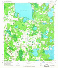
 1964 Jacksonville Heights1965 Print · USGSThe Florida-Duval county border comes alive in the mid-1960s as suburban subdivisions like Oak Hill and Ridgewood expand near the U S Naval Air Station (Cecil Field). Genealogists and historians can trace the development of local congregations at Oak Crest Ch or explore the drainage of the Ortega River.4 unique versions available
 - 1964 Map of Orange Park, 1965 Print
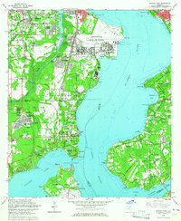 1964 Orange Park1965 Print · USGSGreater Jacksonville and the St. Johns River shores are captured here in the mid-sixties during a period of rapid naval and suburban growth. Researchers can trace the development of Orange Park, the massive Jacksonville Naval Air Station, and local landmarks like Laurel Grove Cem.5 unique versions available
 - 1966 Map of Melrose, 1967 Print
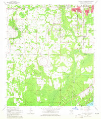
 1966 Melrose1967 Print · USGSThe northern Florida lake country comes alive in the 1960s, showing a landscape defined by the convergence of four county lines at Melrose. Genealogists and historians can trace rail-side communities like Campville and find local landmarks such as St Johns Ch and Nelson Cem.3 unique versions available
End of results
Showing maps 1-5 of 5
Top cities of Clay County
- Middleburg historical maps
- Orange Park historical maps
- Green Cove Springs historical maps
- Keystone Heights historical maps
- Penney Farms historical maps
Frequently asked questions
- What are the different types of historical maps available for Clay County?
- What is the oldest map of Clay County?
- Where can I purchase historical maps of Clay County for my home or office?
- Where can I download high-res historical maps of Clay County?
- Are there historical topographic maps available for Clay County?
- Is there historical aerial imagery available for Clay County?
- Where are historical maps of Clay County sourced from?