1950s Maps of Green Cove Springs, Florida
Explore 5 historic maps of Green Cove Springs from the 1950s. These maps offer a rare glimpse into what life looked like during the 1950s — showing old roads, neighborhoods, homes, and landmarks that have changed or disappeared over time.
Whether you're researching your family's past, planning a metal detecting trip, or studying how Green Cove Springs's landscape evolved across the 1950s, these high-resolution maps are a powerful tool for exploring the history of this region.
- Focus on a specific era: All maps on this page are from the 1950s, giving you a focused view of this time period.
- See what’s changed: Compare century-old streets, trails, and buildings to today's modern landscape using overlays and satellite layers.
- Research with precision: Use these maps for genealogy, historical research, land use analysis, or educational projects.
- View, download, or print: Maps are fully viewable online in high resolution, and can be downloaded or printed for your own records.
Start exploring Green Cove Springs's history through authentic maps from the 1950s. This is your window into the past.
Green Cove Springs, FL maps
(5)- 1952 Map of Fleming Island, 1956 Print
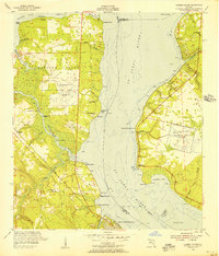 1952 Fleming Island1956 Print · USGSThe St. Johns River corridor shows a transition toward modern aviation and infrastructure in the 1950s. Genealogists and local historians can trace family-named points and community hubs like St Margaret Ch, Hibernia, and the early Fleming Island Airfield.4 unique versions available
 - 1954 Map of Daytona Beach, 1974 Print
 1954 Daytona Beach1974 Print · USGSNortheast Florida is captured in the mid-1950s, showing the transition from river-based commerce to coastal tourism. Researchers can trace the Florida East Coast rail lines and find historic sites like Castillo de San Marcos Nat Mon and Palatka.
 - 1957 Map of Jacksonville, 1967 Print
 1957 Jacksonville1967 Print · USGSCoastal Florida and Georgia meet in the late fifties, showcasing a landscape of naval aviation, deep-water terminals, and barrier island communities. Researchers can trace the mid-century footprints of NAS Jacksonville, find small communities like Franklintown, and locate the historic Fort Clinch State Park.3 unique versions available
 - 1958 Map of Daytona Beach
 1958 Daytona Beach1958 Print · USGSThe Florida coast and St. Johns River valley are captured in the late 1950s, showing a landscape defined by citrus-belt rail towns and Atlantic shorelines. Genealogists can trace family roots through riverside settlements like Palatka and Welaka or coastal hubs like Daytona Beach.2 unique versions available
 - 1959 Map of Jacksonville
 1959 Jacksonville1959 Print · USGSNortheast Florida and Southeast Georgia are seen here in the late fifties, dominated by the maritime activity of the St Johns River and the Atlantic coast. Researchers can trace the mid-century layout of Jacksonville and identify sprawling military sites like Camp Blanding Military Reservation and Kings Bay Ammunition Terminal.
End of results
Showing maps 1-5 of 5
Top cities near Green Cove Springs
- Jacksonville historical maps
- Fruit Cove historical maps
- Middleburg historical maps
- Orange Park historical maps
- Penney Farms historical maps
Frequently asked questions
- What are the different types of historical maps available for Green Cove Springs?
- What is the oldest map of Green Cove Springs?
- Where can I purchase historical maps of Green Cove Springs for my home or office?
- Where can I download high-res historical maps of Green Cove Springs?
- Are there historical topographic maps available for Green Cove Springs?
- Is there historical aerial imagery available for Green Cove Springs?
- Where are historical maps of Green Cove Springs sourced from?