1940s Maps of Green Cove Springs, Florida
Explore 4 historic maps of Green Cove Springs from the 1940s. These maps offer a rare glimpse into what life looked like during the 1940s — showing old roads, neighborhoods, homes, and landmarks that have changed or disappeared over time.
Whether you're researching your family's past, planning a metal detecting trip, or studying how Green Cove Springs's landscape evolved across the 1940s, these high-resolution maps are a powerful tool for exploring the history of this region.
- Focus on a specific era: All maps on this page are from the 1940s, giving you a focused view of this time period.
- See what’s changed: Compare century-old streets, trails, and buildings to today's modern landscape using overlays and satellite layers.
- Research with precision: Use these maps for genealogy, historical research, land use analysis, or educational projects.
- View, download, or print: Maps are fully viewable online in high resolution, and can be downloaded or printed for your own records.
Start exploring Green Cove Springs's history through authentic maps from the 1940s. This is your window into the past.
Green Cove Springs, FL maps
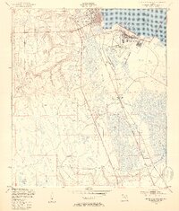
(4)- 1947 Map of Bostwick
 1947 Bostwick1947 Print · USGSThe Saint Johns River valley in the late 1940s reveals a landscape defined by its waterways and timber-era rail lines. Researchers can trace historic river access at Clay Landing and Picolata, or follow the Atlantic Coast Line through Bostwick.
 - 1948 Map of Jacksonville
 1948 Jacksonville1948 Print · USGSNortheast Florida and Southeast Georgia's coastal waterways and railroad towns are captured here in the years following the war. Genealogists can trace family connections through river towns like St Marys or identify long-standing military landmarks like Jacksonville NAS.
 - 1949 Map of Green Cove Springs, 1953 Print
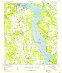
 1949 Green Cove Springs1953 Print · USGSGreen Cove Springs sits at a post-war crossroads where military installations and river life meet. Genealogists and historians can trace the footprint of the U S Naval Station alongside local landmarks like Hickory Grove Ch and Walkill.5 unique versions available
 - 1949 Map of Bostwick, 1955 Print
 1949 Bostwick1955 Print · USGSThe St. Johns River corridor comes to life in the late 1940s, showing a landscape of military installations and quiet river landings. Researchers can trace family roots at Shiloh Ch or Bostwick, and locate vanished river hubs like Picolata and Tocoi.
End of results
Showing maps 1-4 of 4
Top cities near Green Cove Springs
- Jacksonville historical maps
- Fruit Cove historical maps
- Middleburg historical maps
- Orange Park historical maps
- Penney Farms historical maps
Frequently asked questions
- What are the different types of historical maps available for Green Cove Springs?
- What is the oldest map of Green Cove Springs?
- Where can I purchase historical maps of Green Cove Springs for my home or office?
- Where can I download high-res historical maps of Green Cove Springs?
- Are there historical topographic maps available for Green Cove Springs?
- Is there historical aerial imagery available for Green Cove Springs?
- Where are historical maps of Green Cove Springs sourced from?