1950s Maps of Englewood, Jacksonville
Explore 4 historic maps of Englewood from the 1950s. These maps offer a rare glimpse into what life looked like during the 1950s — showing old roads, neighborhoods, homes, and landmarks that have changed or disappeared over time.
Whether you're researching your family's past, planning a metal detecting trip, or studying how Englewood's landscape evolved across the 1950s, these high-resolution maps are a powerful tool for exploring the history of this region.
- Focus on a specific era: All maps on this page are from the 1950s, giving you a focused view of this time period.
- See what’s changed: Compare century-old streets, trails, and buildings to today's modern landscape using overlays and satellite layers.
- Research with precision: Use these maps for genealogy, historical research, land use analysis, or educational projects.
- View, download, or print: Maps are fully viewable online in high resolution, and can be downloaded or printed for your own records.
Start exploring Englewood's history through authentic maps from the 1950s. This is your window into the past.
Englewood, Jacksonville maps
(4)- 1950 Map of Arlington
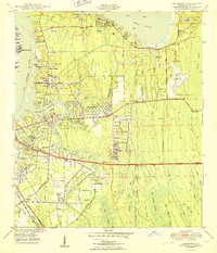 1950 Arlington1950 Print · USGSCoastal Duval County comes alive in the early fifties as the St. Johns River communities begin to expand eastward into the pine lands. Local researchers can trace family roots through several rural burial grounds like Gilmore Cem and Parsons Cem, or locate historic landmarks such as Craig Field and the ancient Indian Mound.2 unique versions available
 - 1950 Map of Jacksonville
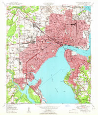 1950 Jacksonville1950 Print · USGSJacksonville at the dawn of the fifties was a thriving riverfront hub of industry and commerce. Genealogists and researchers can trace the city's layout through numerous local landmarks, from Union Station and Edward Waters College to neighborhoods like Ortega and St Nicholas.
 - 1957 Map of Jacksonville, 1967 Print
 1957 Jacksonville1967 Print · USGSCoastal Florida and Georgia meet in the late fifties, showcasing a landscape of naval aviation, deep-water terminals, and barrier island communities. Researchers can trace the mid-century footprints of NAS Jacksonville, find small communities like Franklintown, and locate the historic Fort Clinch State Park.3 unique versions available
 - 1959 Map of Jacksonville
 1959 Jacksonville1959 Print · USGSNortheast Florida and Southeast Georgia are seen here in the late fifties, dominated by the maritime activity of the St Johns River and the Atlantic coast. Researchers can trace the mid-century layout of Jacksonville and identify sprawling military sites like Camp Blanding Military Reservation and Kings Bay Ammunition Terminal.
End of results
Showing maps 1-4 of 4
Frequently asked questions
- What are the different types of historical maps available for Englewood?
- What is the oldest map of Englewood?
- Where can I purchase historical maps of Englewood for my home or office?
- Where can I download high-res historical maps of Englewood?
- Are there historical topographic maps available for Englewood?
- Is there historical aerial imagery available for Englewood?
- Where are historical maps of Englewood sourced from?