1900s (20th Century) Maps of Nature Trail, Escambia County
Explore 10 historic maps of Nature Trail from the 1900s (20th Century). These maps offer a rare glimpse into what life looked like during the 1900s — showing old roads, neighborhoods, homes, and landmarks that have changed or disappeared over time.
Whether you're researching your family's past, planning a metal detecting trip, or studying how Nature Trail's landscape evolved across the 1900s, these high-resolution maps are a powerful tool for exploring the history of this region.
- Focus on a specific era: All maps on this page are from the 1900s, giving you a focused view of this time period.
- See what’s changed: Compare century-old streets, trails, and buildings to today's modern landscape using overlays and satellite layers.
- Research with precision: Use these maps for genealogy, historical research, land use analysis, or educational projects.
- View, download, or print: Maps are fully viewable online in high resolution, and can be downloaded or printed for your own records.
Start exploring Nature Trail's history through authentic maps from the 1900s. This is your window into the past.
Nature Trail, Escambia County maps
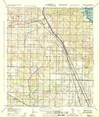
(10)- 1921 Map of Muscogee
 1921 Muscogee1921 Print · USGSThe Alabama-Florida borderlands come to life in the early 1920s, showing the river-and-rail network that sustained the region. Trace old ferry crossings like Billy Malone Ferry and landmarks such as Lathams Chapel and Seminola P.O.
 - 1941 Map of Muscogee, 1956 Print
 1941 Muscogee1956 Print · USGSThe Florida-Alabama borderlands come alive in the early 1940s as the Perdido River and major rail lines dictate the rhythm of local commerce. Researchers can trace family roots through numerous rural landmarks like Barrineau Park, the Mission Cem, and Quintette Sch.2 unique versions available
 - 1943 Map of Muscogee
 1943 Muscogee1943 Print · USGSThe Florida-Alabama borderlands come alive in the early 1940s as the river-and-rail economy pulses through Muscogee and Cantonment. Genealogists can trace family footprints at Mission Cem, Sunnyhill Sch, and rural stops along the Louisville and Nashville RR.2 unique versions available
 - 1944 Map of Gonzalez
 1944 Gonzalez1944 Print · USGSNorth of Pensacola in the mid-1940s, this area centers on the rail hub of Cantonment and the surrounding rural communities. Genealogists can locate family landmarks like Jordan Cemetery, the Tate School, and the historic Farm Hill Church.
 - 1957 Map of Pensacola, 1967 Print
 1957 Pensacola1967 Print · USGSThe Florida Panhandle and Alabama coast are seen here at the height of the Cold War, showcasing a unique mix of military aviation and emerging beach tourism. Genealogists and local historians can trace legacy sites like Old Corry Field, the lumber town of Bagdad, and the coastal reaches of Santa Rosa Island.3 unique versions available
 - 1959 Map of Pensacola
 1959 Pensacola1959 Print · USGSThe Florida Panhandle and Alabama coast come alive in this late fifties survey of military aviation and maritime life. Genealogists can trace family roots in Bagdad, Loxley, and Milton while mapping the rails of the Louisville and Nashville.
 - 1960 Map of Pensacola
 1960 Pensacola1960 Print · USGSThe Florida Panhandle and Alabama's eastern shore are shown during a period of rapid military and coastal growth. Genealogists and historians can trace the mid-century footprints of Warrington, the Pensacola NAS (Chevalier), and the Blackwater River timber lands.
 - 1978 Map of Cantonment
 1978 Cantonment1978 Print · USGSNorth of Pensacola in the late seventies, this area shows a mix of industrial utility and established rural communities. Researchers can trace family sites at Santa Marie Cem or follow the rails of the Louisville and Nashville through Cantonment.3 unique versions available
 - 1981 Map of Bay Minette
 1981 Bay Minette1981 Print · USGSThe Alabama-Florida borderlands come to life in the early 1980s as the river delta meets the growing coastal communities. Researchers can trace the Louisville and Nashville rail lines or locate historical points like Twenty-two Mile Bluff and the Blackwater River State Forest.2 unique versions available
 - 1994 Map of Cantonment, 2000 Print
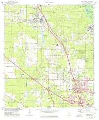
 1994 Cantonment2000 Print · USGSNorth of Pensacola in the 1990s, this area reflects a complex mix of heavy industry, military outposts, and riverfront wetlands. Researchers can locate community landmarks like Plainview Cem Ch, the Louisville and Nashville rail line, and the Escambia River islands.
End of results
Showing maps 1-10 of 10
Frequently asked questions
- What are the different types of historical maps available for Nature Trail?
- What is the oldest map of Nature Trail?
- Where can I purchase historical maps of Nature Trail for my home or office?
- Where can I download high-res historical maps of Nature Trail?
- Are there historical topographic maps available for Nature Trail?
- Is there historical aerial imagery available for Nature Trail?
- Where are historical maps of Nature Trail sourced from?