1900s (20th Century) Maps of Summer Lakes, Pensacola
Explore 10 historic maps of Summer Lakes from the 1900s (20th Century). These maps offer a rare glimpse into what life looked like during the 1900s — showing old roads, neighborhoods, homes, and landmarks that have changed or disappeared over time.
Whether you're researching your family's past, planning a metal detecting trip, or studying how Summer Lakes's landscape evolved across the 1900s, these high-resolution maps are a powerful tool for exploring the history of this region.
- Focus on a specific era: All maps on this page are from the 1900s, giving you a focused view of this time period.
- See what’s changed: Compare century-old streets, trails, and buildings to today's modern landscape using overlays and satellite layers.
- Research with precision: Use these maps for genealogy, historical research, land use analysis, or educational projects.
- View, download, or print: Maps are fully viewable online in high resolution, and can be downloaded or printed for your own records.
Start exploring Summer Lakes's history through authentic maps from the 1900s. This is your window into the past.
Summer Lakes, Pensacola maps
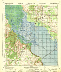
(10)- 1920 Map of Milton
 1920 Milton1920 Print · USGSSanta Rosa County's timber and rail economy is captured here just after the first World War. Genealogists and historians can trace the lumber industry through the Manu'g. and Land Co. R.R. and old coastal sites like Bagdad, Floridatown, and Roeville Sta.
 - 1941 Map of Milton, 1956 Print
 1941 Milton1956 Print · USGSSanta Rosa County at the start of the 1940s is shown here as a landscape of timber-towns and tidewater rail junctions. Genealogists can trace family names at Allen Cem, Robinson Sch, and the riverside settlements of Bagdad and Floridatown.2 unique versions available
 - 1943 Map of Milton
 1943 Milton1943 Print · USGSSanta Rosa and Escambia counties are captured here in the early 1940s at the confluence of the Blackwater and Escambia rivers. Researchers can trace the waterfront history of MILTON and Bagdad or locate rural landmarks like Union Valley Ch and Conners Still.2 unique versions available
 - 1944 Map of Floridatown
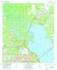
 1944 Floridatown1944 Print · USGSCoastal Santa Rosa County is captured here during the mid-forties, showing the vital river-and-rail hub where the Escambia delta meets the bay. Trace the wartime footprint of Ellyson Field and the historic streets of Floridatown and Pace.
 - 1957 Map of Pensacola, 1967 Print
 1957 Pensacola1967 Print · USGSThe Florida Panhandle and Alabama coast are seen here at the height of the Cold War, showcasing a unique mix of military aviation and emerging beach tourism. Genealogists and local historians can trace legacy sites like Old Corry Field, the lumber town of Bagdad, and the coastal reaches of Santa Rosa Island.3 unique versions available
 - 1959 Map of Pensacola
 1959 Pensacola1959 Print · USGSThe Florida Panhandle and Alabama coast come alive in this late fifties survey of military aviation and maritime life. Genealogists can trace family roots in Bagdad, Loxley, and Milton while mapping the rails of the Louisville and Nashville.
 - 1960 Map of Pensacola
 1960 Pensacola1960 Print · USGSThe Florida Panhandle and Alabama's eastern shore are shown during a period of rapid military and coastal growth. Genealogists and historians can trace the mid-century footprints of Warrington, the Pensacola NAS (Chevalier), and the Blackwater River timber lands.
 - 1978 Map of Pace
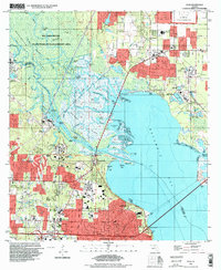
 1978 Pace1978 Print · USGSCoastal development and river industry converge near Escambia Bay during the late seventies. Family historians can trace local roots at Whitmire Cem or follow the growth of Pace and the University of West Florida campus.3 unique versions available
 - 1981 Map of Bay Minette
 1981 Bay Minette1981 Print · USGSThe Alabama-Florida borderlands come to life in the early 1980s as the river delta meets the growing coastal communities. Researchers can trace the Louisville and Nashville rail lines or locate historical points like Twenty-two Mile Bluff and the Blackwater River State Forest.2 unique versions available
 - 1994 Map of Pace, 1999 Print
 1994 Pace1999 Print · USGSThe Escambia River delta and the growing suburbs of Pensacola are captured here in the mid-1990s as the region's industrial and academic footprints expanded. Researchers can trace the layout of the University of West Florida or locate historic sites like Whitmires Cem and Floridatown.
End of results
Showing maps 1-10 of 10
Frequently asked questions
- What are the different types of historical maps available for Summer Lakes?
- What is the oldest map of Summer Lakes?
- Where can I purchase historical maps of Summer Lakes for my home or office?
- Where can I download high-res historical maps of Summer Lakes?
- Are there historical topographic maps available for Summer Lakes?
- Is there historical aerial imagery available for Summer Lakes?
- Where are historical maps of Summer Lakes sourced from?