1940s Maps of Gadsden County, Florida
Explore 5 historic maps of Gadsden County from the 1940s. These maps offer a rare glimpse into what life looked like during the 1940s — showing old roads, neighborhoods, homes, and landmarks that have changed or disappeared over time.
Whether you're researching your family's past, planning a metal detecting trip, or studying how Gadsden County's landscape evolved across the 1940s, these high-resolution maps are a powerful tool for exploring the history of this region.
- Focus on a specific era: All maps on this page are from the 1940s, giving you a focused view of this time period.
- See what’s changed: Compare century-old streets, trails, and buildings to today's modern landscape using overlays and satellite layers.
- Research with precision: Use these maps for genealogy, historical research, land use analysis, or educational projects.
- View, download, or print: Maps are fully viewable online in high resolution, and can be downloaded or printed for your own records.
Start exploring Gadsden County's history through authentic maps from the 1940s. This is your window into the past.
Gadsden County, FL maps
(5)- 1940 Map of Tallahassee, 1958 Print
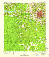 1940 Tallahassee1958 Print · USGSFlorida's capital city and the surrounding Leon County pine forests are captured here just before the mid-century expansion. Genealogists and local historians can trace rural communities like Hilliardville and Woodville alongside landmarks like Richardson Sch and Lake Talquin.2 unique versions available
 - 1942 Map of Tallahassee
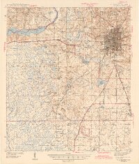
 1942 Tallahassee1942 Print · USGSTallahassee and the surrounding Leon County area appear here in the early 1940s, balancing its role as a college town with the wilderness of the Apalachicola National Forest. Researchers can trace the rural church and school networks of Woodville and Spring Hill, or locate early campus footprints for Florida State College for Women.
 - 1943 Map of Tallahassee
 1943 Tallahassee1943 Print · USGSMid-century Tallahassee and the eastern edge of the Apalachicola National Forest appear here in the years just before post-war suburban growth. Genealogists can trace rural communities through landmarks like Florida Agricultural and Mechanical College, Hilliardville, and the Gum Pond Sch.2 unique versions available
 - 1943 Map of Lake Talquin
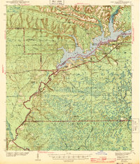 1943 Lake Talquin1943 Print · USGSFlorida's northern forest and river country are mapped here in the early 1940s as the Apalachicola National Forest meets the shores of Lake Talquin. Genealogists can locate family landmarks like Bradwell Sch, Antioch Ch, and numerous private landings along the Ochlockonee River.2 unique versions available
 - 1945 Map of Hosford
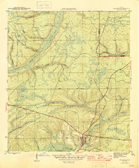 1945 Hosford1945 Print · USGSLiberty County was characterized by its timber-hauling rail lines and creek-fed bottomlands in the mid-1940s. Local researchers can trace the old Apalachicola Northern tracks, locate Kent Cem, and explore the rural layouts of Hosford and Lowry.3 unique versions available
End of results
Showing maps 1-5 of 5
Top cities of Gadsden County
- Quincy historical maps
- Chattahoochee historical maps
- Midway historical maps
- Havana historical maps
- Gretna historical maps
- Greensboro historical maps
Frequently asked questions
- What are the different types of historical maps available for Gadsden County?
- What is the oldest map of Gadsden County?
- Where can I purchase historical maps of Gadsden County for my home or office?
- Where can I download high-res historical maps of Gadsden County?
- Are there historical topographic maps available for Gadsden County?
- Is there historical aerial imagery available for Gadsden County?
- Where are historical maps of Gadsden County sourced from?