1980s Maps of Gadsden County, Florida
Explore 13 historic maps of Gadsden County from the 1980s. These maps offer a rare glimpse into what life looked like during the 1980s — showing old roads, neighborhoods, homes, and landmarks that have changed or disappeared over time.
Whether you're researching your family's past, planning a metal detecting trip, or studying how Gadsden County's landscape evolved across the 1980s, these high-resolution maps are a powerful tool for exploring the history of this region.
- Focus on a specific era: All maps on this page are from the 1980s, giving you a focused view of this time period.
- See what’s changed: Compare century-old streets, trails, and buildings to today's modern landscape using overlays and satellite layers.
- Research with precision: Use these maps for genealogy, historical research, land use analysis, or educational projects.
- View, download, or print: Maps are fully viewable online in high resolution, and can be downloaded or printed for your own records.
Start exploring Gadsden County's history through authentic maps from the 1980s. This is your window into the past.
Gadsden County, FL maps
(13)- 1982 Map of Mt Pleasant
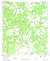 1982 Mt Pleasant1982 Print · USGSThe Florida-Georgia borderlands are captured here in the early eighties, showcasing a rural landscape tied together by rail and timber. Researchers can trace family sites like Hannatown Cem or historic local congregations including Mt Pleasant Ch and Morning Star Ch.
 - 1982 Map of Sneads
 1982 Sneads1982 Print · USGSThe Florida-Georgia borderlands come to life in this early 1980s record of Jackson County, where the massive reservoir meets the winding river system. Genealogists and local historians can trace family sites at Yan Cem and Sinai Cem or locate the infrastructure of Sneads and Grand Ridge.
 - 1982 Map of Dogtown, 1983 Print
 1982 Dogtown1983 Print · USGSThe Florida-Georgia borderlands in the early eighties were defined by rural settlements and active industrial pits. Genealogists and historians can trace family-named sites like Pottevint Cem and Mt Hosey Cem, alongside communities at Dogtown and Scottstown.
 - 1982 Map of Gretna, 1983 Print
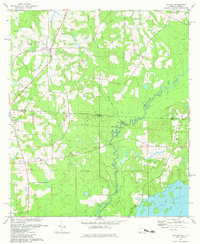
 1982 Gretna1983 Print · USGSGadsden County in the early eighties shows a landscape of small agricultural hubs and millponds along the SEABOARD line. Local historians can trace established community landmarks like Gretna Sch and Sunny Dell Cem, or explore the historic boundaries of the Forbes Purchase.2 unique versions available
 - 1982 Map of Chattahoochee, 1983 Print
 1982 Chattahoochee1983 Print · USGSFlorida's riverfront history is on display here in the early 1980s, where the Flint and Apalachicola Rivers converge at the state line. Trace the extensive STATE HOSPITAL grounds and the rail junction at River Junction, or locate family sites like Farrell Cem and Rosedale.
 - 1982 Map of Lake Jackson, 1983 Print
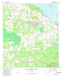
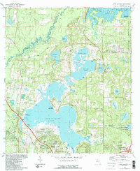 1982 Lake Jackson1983 Print · USGSNorth of Tallahassee in the early eighties, this area balances a growing suburban footprint with its ancient foundations at the Lake Jackson Mounds. Genealogists and historians can locate early family landmarks and estates, from El Destinado to Memory Gardens Cem and St Matthews Ch.2 unique versions available
 - 1982 Map of Quincy, 1983 Print
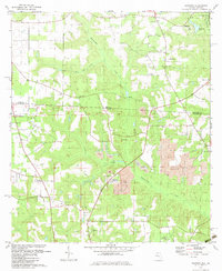
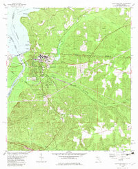
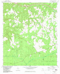
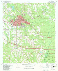 1982 Quincy1983 Print · USGSQuincy and its rural Gadsden County surroundings are captured in the early eighties as a mix of industrial activity and preserved southern wildlands. Researchers can trace historic property boundaries like the Forbes Purchase Line or locate ancestral sites at Western Cem and New Bethel Ch.
 - 1982 Map of Rock Bluff, 1983 Print
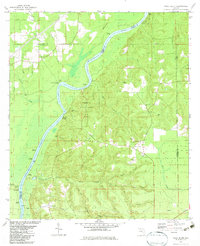 1982 Rock Bluff1983 Print · USGSThe Apalachicola River bluffs of Liberty County are captured here in the early eighties, centered on the diverse terrain of Torreya State Park. Researchers can trace old river access points like Hickory Landing and Porters Landing alongside several local churches and burial sites.
 - 1982 Map of Calvary, 1983 Print
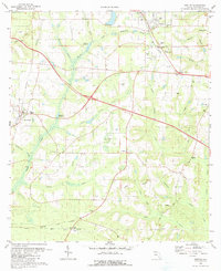
 1982 Calvary1983 Print · USGSThe Georgia-Florida state line comes alive in the early eighties as the Ochlockonee River winds toward Lake Iamonia. Genealogists and historians can trace numerous country landmarks, from Beck Branch Sch to local burial sites like Butler Cem and Barber Cem.
 - 1982 Map of Sycamore, 1983 Print
 1982 Sycamore1983 Print · USGSGadsden and Liberty counties are shown here in the early eighties, a rural landscape shaped by old land grants and deep-seated family roots. Genealogists and local historians can trace legacy sites like Gause Cem, Sycamore Ch, and the historical Forbes Purchase Line.
 - 1982 Map of Havana South, 1983 Print
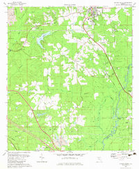 1982 Havana South1983 Print · USGSGadsden County in the early eighties shows a transition from rural timber and mining lands toward expanding residential and aviation hubs. Genealogists and local historians can locate several family-named sites like Ferrell Cem and Hopewell Cem, or trace the rail-side settlements of Scotland and Gibson.
 - 1982 Map of Havana North, 1983 Print
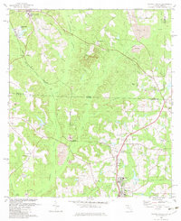 1982 Havana North1983 Print · USGSGadsden County and the Georgia-Florida borderlands were defined by clay mining and rural community life in the early eighties. Genealogists and historians can trace family roots through sites like Griffin Cem, Mayflower Ch, and the settlements at Amsterdam and Jamieson.
 - 1988 Map of Tallahassee
 1988 Tallahassee1988 Print · USGSThe Florida Panhandle and South Georgia are captured here in the late eighties, showing the expansion of the regional highway network and coastal growth. Genealogists and historians can trace rail lines like the Seaboard System Railroad or locate family roots in Blountstown, Graceville, or Crawfordville.2 unique versions available
End of results
Showing maps 1-13 of 13
Top cities of Gadsden County
- Quincy historical maps
- Chattahoochee historical maps
- Midway historical maps
- Havana historical maps
- Gretna historical maps
- Greensboro historical maps
Frequently asked questions
- What are the different types of historical maps available for Gadsden County?
- What is the oldest map of Gadsden County?
- Where can I purchase historical maps of Gadsden County for my home or office?
- Where can I download high-res historical maps of Gadsden County?
- Are there historical topographic maps available for Gadsden County?
- Is there historical aerial imagery available for Gadsden County?
- Where are historical maps of Gadsden County sourced from?