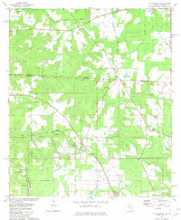
1982 Map of Mt Pleasant
USGS Topo · Published 1982About this map
Mt Pleasant serves as a central hub in this corner of the Florida panhandle, where the interstate age meets the legacy of the old Southern rail corridors. The survey captures a landscape defined by its borderlands, split by the Georgia Florida state line and the historic Watson Line. Transportation is a primary theme, with the diagonal sweep of the Seaboard Coast Line and the Apalachicola Northern railroad crossing the rural terrain. Local life is anchored by a dense network of country churches and cemeteries, including St Mary Ch, New Hope Ch, and the Hannatown Cem. Near Hardaway, the terrain is marked by the winding paths of South Mosquito Creek and Hardaway Ck, reflecting the area's agricultural and rural character before modern development significantly altered the traditional settlement patterns of Gadsden and Decatur counties.
Find a feature on this map
32 named features on this map. Tap any name to fly to it.
Don’t see what you’re looking for? This feature index may not catch every label — zoom into the map to look around manually.
Map Details
Editions of this 1982 Mt Pleasant Map
This is the sole edition of this map. No revisions or reprints were ever made.
Other maps of this area

1954 · Tallahassee
USGS Topo · 1:250,000

1955 · Reynoldsville
USGS Topo · 1:24,000

1955 · Sycamore
USGS Topo · 1:24,000

1955 · Chattahoochee
USGS Topo · 1:24,000

1955 · Bainbridge
USGS Topo · 1:62,500

1955 · Mt Pleasant
USGS Topo · 1:24,000

1956 · Dogtown
USGS Topo · 1:24,000

1959 · Tallahassee
USGS Topo · 1:250,000

1959 · Gretna
USGS Topo · 1:24,000

1959 · Quincy
USGS Topo · 1:24,000