
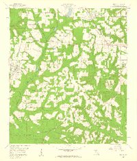
1959 Map of Gretna
USGS Topo · Published 1960About this map
Gretna and Greensboro anchor this 1959 survey of Gadsden County, where the agricultural landscape is defined by a dense network of creek branches and family-named landmarks. The Seaboard Air Line railroad cuts diagonally across the northern terrain, passing through the heart of Gretna and near Springfield Sch. Further south, the landscape becomes more rural, punctuated by small settlements like Sawdust and a series of rural spiritual centers including St Marys Ch, Providence Ch, and Macedonia Ch. The topography is shaped by the complex drainage systems of Telogia Creek and Rocky Comfort Creek, which supported early local industry as evidenced by Shepards Millpond and Hannas Millpond. Significant historical property boundaries are also noted, such as the Forbes Purchase Line, providing a glimpse into the land divisions and communal structures of mid-century Florida's panhandle region.
Find a feature on this map
42 named features on this map. Tap any name to fly to it.
Don’t see what you’re looking for? This feature index may not catch every label — zoom into the map to look around manually.
Map Details
Editions of this 1959 Gretna Map
2 editions found
Other maps of this area

1943 · Lake Talquin
USGS Topo · 1:62,500

1945 · Hosford
USGS Topo · 1:31,680

1954 · Tallahassee
USGS Topo · 1:250,000

1955 · Sycamore
USGS Topo · 1:24,000

1955 · Chattahoochee
USGS Topo · 1:24,000

1955 · Mt Pleasant
USGS Topo · 1:24,000

1956 · Dogtown
USGS Topo · 1:24,000

1959 · Tallahassee
USGS Topo · 1:250,000

1959 · Quincy
USGS Topo · 1:24,000

1960 · Tallahassee
USGS Topo · 1:250,000