
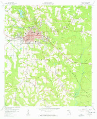
1959 Map of Quincy
USGS Topo · Published 1960About this map
Quincy sits as the central hub of Gadsden County in the late 1950s, its urban footprint concentrated around the Po and Quincy High Sch while surrounded by a landscape defined by rolling creek basins and local industry. The Seaboard Air Line railroad cuts through the terrain, connecting the town to rural outposts like Littman and Santa Clara. A significant historical boundary, the Forbes Purchase Line, bisects the southern half of the quadrangle, reflecting early Florida land claims. The map reveals a high density of community landmarks, particularly country churches such as St Marks Ch and Mt Sinai Ch, which serve as anchors for the outlying rural population. To the north, the topography is marked by the Interlocking Lakes and the Quincy Airport, while scattered Strip Mine and gravel operations suggest the area's geological and economic activity during this era.
Find a feature on this map
54 named features on this map. Tap any name to fly to it.
Don’t see what you’re looking for? This feature index may not catch every label — zoom into the map to look around manually.
Map Details
Editions of this 1959 Quincy Map
2 editions found
Other maps of this area

1940 · Tallahassee
USGS Topo · 1:62,500

1942 · Tallahassee
USGS Topo · 1:62,500

1943 · Tallahassee
USGS Topo · 1:62,500

1943 · Lake Talquin
USGS Topo · 1:62,500

1954 · Tallahassee
USGS Topo · 1:250,000

1955 · Mt Pleasant
USGS Topo · 1:24,000

1956 · Havana North
USGS Topo · 1:24,000

1956 · Dogtown
USGS Topo · 1:24,000

1959 · Tallahassee
USGS Topo · 1:250,000

1959 · Gretna
USGS Topo · 1:24,000