
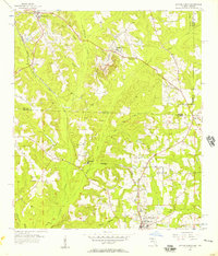
1956 Map of Havana North
USGS Topo · Published 1957About this map
Attapulgus Creek and its many branches, including Miller Branch and Gin Branch, drain this rolling landscape along the Georgia Florida state line during the mid-1950s. The region is defined by the Seaboard Air Line railroad, which links the northern settlement of Attapulgus down through Laingkat, Jamieson, and Hinson to the larger community of Havana in the south. The prevalence of family-named landmarks like Woodberry Cem, Griffin Cem, and Vickers Cem suggests a deeply rooted agricultural society.
Find a feature on this map
39 named features on this map. Tap any name to fly to it.
Don’t see what you’re looking for? This feature index may not catch every label — zoom into the map to look around manually.
Map Details
Editions of this 1956 Havana North Map
2 editions found
Other maps of this area

1954 · Tallahassee
USGS Topo · 1:250,000

1955 · Bainbridge
USGS Topo · 1:62,500

1955 · Whigham
USGS Topo · 1:62,500

1956 · Dogtown
USGS Topo · 1:24,000

1956 · Calvary
USGS Topo · 1:24,000

1959 · Tallahassee
USGS Topo · 1:250,000

1959 · Quincy
USGS Topo · 1:24,000

1960 · Tallahassee
USGS Topo · 1:250,000

1963 · Lake Jackson
USGS Topo · 1:24,000
1963 · Havana South
USGS Topo · 1:24,000