1990s Maps of Gadsden County, Florida
Explore 9 historic maps of Gadsden County from the 1990s. These maps offer a rare glimpse into what life looked like during the 1990s — showing old roads, neighborhoods, homes, and landmarks that have changed or disappeared over time.
Whether you're researching your family's past, planning a metal detecting trip, or studying how Gadsden County's landscape evolved across the 1990s, these high-resolution maps are a powerful tool for exploring the history of this region.
- Focus on a specific era: All maps on this page are from the 1990s, giving you a focused view of this time period.
- See what’s changed: Compare century-old streets, trails, and buildings to today's modern landscape using overlays and satellite layers.
- Research with precision: Use these maps for genealogy, historical research, land use analysis, or educational projects.
- View, download, or print: Maps are fully viewable online in high resolution, and can be downloaded or printed for your own records.
Start exploring Gadsden County's history through authentic maps from the 1990s. This is your window into the past.
Gadsden County, FL maps
(9)- 1990 Map of Hosford
 1990 Hosford1990 Print · USGSThe Florida Panhandle near the Gadsden and Liberty County line is documented here in the early nineties, centered on the community of Hosford. Researchers can trace old family sites near Kent Cem or locate the rural settlement of Lowry amidst Telogia Creek and its many branches.
 - 1994 Map of Gretna, 1998 Print
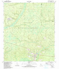
 1994 Gretna1998 Print · USGSGadsden County in the 1990s remained a landscape of rural settlements and timberland management. Genealogists can trace family footprints through sites like Sunny Dell Cem, St Marys Ch, and the small community at Sawdust.
 - 1994 Map of Sycamore, 1998 Print
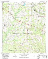
 1994 Sycamore1998 Print · USGSGadsden County's rural landscape is mapped here in the late twentieth century, showing a network of small churches and family land lines. Genealogists can trace property markers like the Forbes Purchase Line or locate ancestral sites at Smith Cem and Gause Cem.2 unique versions available
 - 1994 Map of Havana South, 1998 Print
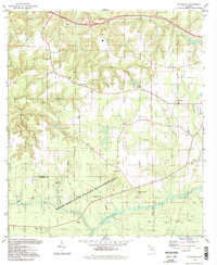
 1994 Havana South1998 Print · USGSGadsden County in the 1990s was a landscape where tobacco-growing history met the wild wetlands of the Ochlockonee. Local historians can trace old homesteads near Scotland and Gibson, or locate family sites like Nicholson-Freeman Cem and St James Ch.
 - 1994 Map of Sneads, 1998 Print
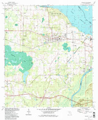 1994 Sneads1998 Print · USGSJackson County, Florida, is captured here in the 1990s as a vital crossroads of river commerce and state conservation. Researchers can trace historic family burial sites and local congregations including Sardis Cem, St Peter Cem, and Sinai Ch.
 - 1994 Map of Chattahoochee, 1998 Print
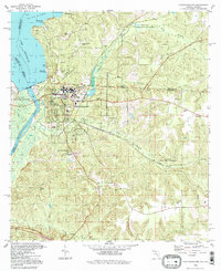 1994 Chattahoochee1998 Print · USGSChattahoochee and the Florida-Georgia border are captured here in the mid-1990s at the critical junction of the Flint and Apalachicola Rivers. Researchers can trace institutional history at the Florida State Hospital or locate family sites like White Cem and Hardin Heights.
 - 1994 Map of Mt Pleasant, 1998 Print
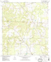 1994 Mt Pleasant1998 Print · USGSThe Georgia-Florida borderlands come to life in the 1990s, revealing a landscape of rural settlements and cross-border communities. Researchers can trace family history through numerous country churches like St Stevens Ch and local burial sites like Hannatown Cem.
 - 1994 Map of Quincy, 1998 Print
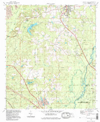
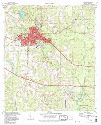 1994 Quincy1998 Print · USGSQuincy and its surrounding Gadsden County countryside are captured here in the late nineties, documenting the town's growth alongside its conservation lands. Genealogists and local historians can locate numerous burial sites and schools, from Hillcrest Cem to Stewart Street Sch, and trace the historic Forbes Purchase Line.
 - 1999 Map of Lake Jackson, 2003 Print
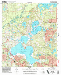 1999 Lake Jackson2003 Print · USGSTallahassee's northward expansion into Leon County is caught here at a moment of transition in the late nineties. Genealogists and researchers can trace local family landmarks and institutional roots at Memory Gardens Cem, El Destinado, and St Pauls Ch.
End of results
Showing maps 1-9 of 9
Top cities of Gadsden County
- Quincy historical maps
- Chattahoochee historical maps
- Midway historical maps
- Havana historical maps
- Gretna historical maps
- Greensboro historical maps
Frequently asked questions
- What are the different types of historical maps available for Gadsden County?
- What is the oldest map of Gadsden County?
- Where can I purchase historical maps of Gadsden County for my home or office?
- Where can I download high-res historical maps of Gadsden County?
- Are there historical topographic maps available for Gadsden County?
- Is there historical aerial imagery available for Gadsden County?
- Where are historical maps of Gadsden County sourced from?