1960s Maps of Bell, Florida
Explore 2 historic maps of Bell from the 1960s. These maps offer a rare glimpse into what life looked like during the 1960s — showing old roads, neighborhoods, homes, and landmarks that have changed or disappeared over time.
Whether you're researching your family's past, planning a metal detecting trip, or studying how Bell's landscape evolved across the 1960s, these high-resolution maps are a powerful tool for exploring the history of this region.
- Focus on a specific era: All maps on this page are from the 1960s, giving you a focused view of this time period.
- See what’s changed: Compare century-old streets, trails, and buildings to today's modern landscape using overlays and satellite layers.
- Research with precision: Use these maps for genealogy, historical research, land use analysis, or educational projects.
- View, download, or print: Maps are fully viewable online in high resolution, and can be downloaded or printed for your own records.
Start exploring Bell's history through authentic maps from the 1960s. This is your window into the past.
Bell, FL maps
(2)- 1968 Map of Fourmile Lake, 1971 Print
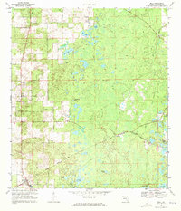
 1968 Fourmile Lake1971 Print · USGSGilchrist County in the late sixties remained a landscape of rural settlements and cypress-lined ponds. Genealogists can trace family sites near Trenton, Joppa Cemetery, and community hubs like Jennings Lake Church.2 unique versions available
 - 1968 Map of Bell, 1971 Print
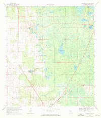
 1968 Bell1971 Print · USGSBell and the surrounding Gilchrist County plains are captured here in the late sixties as a landscape of rail-fed settlements and hidden ponds. Researchers can trace the Seaboard Coast Line through Williford, find rural landmarks like Pierce Chapel, or locate the old Lookout Tower.3 unique versions available
End of results
Showing maps 1-2 of 2
Top cities near Bell
- High Springs historical maps
- Newberry historical maps
- Chiefland historical maps
- Trenton historical maps
- Fanning Springs historical maps
- Branford historical maps
See more
Frequently asked questions
- What are the different types of historical maps available for Bell?
- What is the oldest map of Bell?
- Where can I purchase historical maps of Bell for my home or office?
- Where can I download high-res historical maps of Bell?
- Are there historical topographic maps available for Bell?
- Is there historical aerial imagery available for Bell?
- Where are historical maps of Bell sourced from?