Old Maps of Gulf County, Florida for Hiking & Exploration
Hike through history with 161 historic maps of Gulf County. Explore old trails, ghost towns, and forgotten backroads — perfect for outdoor adventurers and local explorers.
- Rediscover forgotten places: Map out old mining camps, roads, and footpaths that no longer exist on modern maps.
- Layer with modern tools: Combine with LiDAR or satellite views to plan hikes through historical terrain.
- Made for exploration: Popular among hikers, overlanders, and local history lovers.
Use these maps to find adventure and explore the hidden past of Gulf County.
Gulf County, FL maps
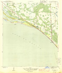
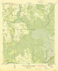
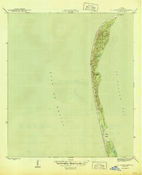
(161)- 1943 Map of St Joseph Spit
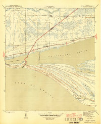
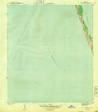 1943 St Joseph Spit1943 Print · USGSThe Florida Panhandle coastline appears in its wild, mid-century state as the War Department surveys this strategic peninsula. Researchers can trace the shifting Sand Dunes and tidal inlets like Pig Bayou along the length of St Joseph Spit.4 unique versions available
 - 1943 Map of Port St. Joe
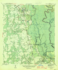
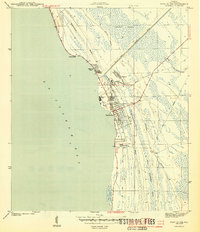 1943 Port St. Joe1943 Print · USGSThe Florida Panhandle's industrial coast is captured during the mid-forties, showing the vital shipping and timber infrastructure of Port St Joe. Researchers can trace the rail-to-sea connection via the Apalachicola Northern and explore early settlements like Milltown and Oak Grove.5 unique versions available
 - 1943 Map of Cape San Blas
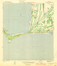 1943 Cape San Blas1943 Print · USGSThe Florida Gulf Coast appears here during the wartime era, dominated by the vital navigation works at Cape San Blas. Maritime researchers can trace the old shoreline from St. Joseph Spit to the Cape San Blas Lighthouse and the small settlement at McNeils.5 unique versions available
 - 1943 Map of Overstreet
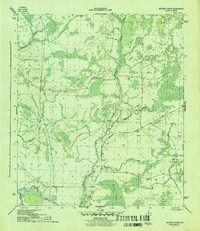
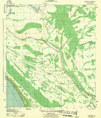 1943 Overstreet1943 Print · USGSGulf County's coastal wetlands and inland shipping routes are captured here during the 1940s. Genealogists and historians can trace family locations such as the Sharp Hardy Homestead and the settlement of Overstreet near Wetappo Creek.5 unique versions available
 - 1943 Map of Indian Pass, 1973 Print
 1943 Indian Pass1973 Print · USGSThe Franklin County coastline was a rugged maritime landscape during the 1940s, marked by small shoreline settlements and military outposts. Researchers can trace the Apalachicola Northern rail line or locate coastal features like Indian Pass, Odena, and Coast Guard Sta No 105.
 - 1943 Map of Jackson River, 1975 Print
 1943 Jackson River1975 Print · USGSThe Florida panhandle river deltas remained largely wild and water-bound in the early 1940s. Genealogists and local historians can trace family land ties near Box R Ranch or navigate the intricate sloughs around St Marks Island and Lake Wimico.
 - 1944 Map of Beacon Hill
 1944 Beacon Hill1944 Print · USGSThe Florida Panhandle coastline and the edge of St. Joseph Bay appear here in the mid-1940s, documenting a landscape of small coastal settlements and tidal marsh. Researchers can trace early development at Beacon Hill and Davis Beach, or locate family-named landmarks like Joe Lamb Branch and Preacher Bryant Ponds.3 unique versions available
 - 1944 Map of White City, 1960 Print
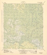
 1944 White City1960 Print · USGSWhite City at the close of the Second World War was a vital hub for timber and water transit. Researchers can trace the path of the Logging RR through the swamps or locate the St Joe Fire Tower and the Gulf Co Canal.
 - 1944 Map of Forbes Island, 1960 Print
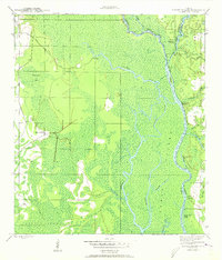 1944 Forbes Island1960 Print · USGSThe Florida Panhandle river system is frozen in time during the mid-1940s, highlighting the industrial timber operations of the Gulf and Liberty county borders. Researchers can trace the path of the Logging RR to remote sites like Lister Camp or locate riverfront hubs such as Brickyard Landing.2 unique versions available
 - 1945 Map of Dead Lake
 1945 Dead Lake1945 Print · USGSThe river and swamp country of the Florida Panhandle is captured here at the end of the war, revealing a landscape defined by its waterways. Researchers can trace historic river landings and family sites like Kentucky Ldg, Iola, and Jehu Cem.4 unique versions available
 - 1945 Map of Forbes Island
 1945 Forbes Island1945 Print · USGSThe river-driven economy of Gulf County is captured here in the mid-1940s, highlighting a landscape of wetlands and timber camps. Genealogists and researchers can trace local landings like Smith Creek Landing and isolated outposts such as Lister Camp or Glenn Hammock.3 unique versions available
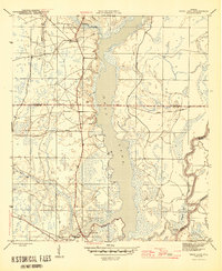
 - 1945 Map of Lake Wimico
 1945 Lake Wimico1945 Print · USGSThe Florida panhandle wetlands are captured here at the end of the war, revealing a landscape of timber and transit. Researchers can trace the path of the Old Logging RR or follow the Intracoastal Waterway past Clay Cut.5 unique versions available
 - 1945 Map of Kennedy Creek
 1945 Kennedy Creek1945 Print · USGSThe Florida Panhandle at the close of the war shows a river-dependent landscape where Liberty and Gulf counties meet. Local historians can trace old river outposts like White Oak Landing and Owl Landing, or locate the Graveyard Pole Lookout deep in the swampy interior.4 unique versions available
 - 1945 Map of White City
 1945 White City1945 Print · USGSGulf County in the mid-1940s reveals a landscape defined by industrial forestry and vital water transit. Trace the early layout of White City and the paths of the Logging RR and Intracoastal Waterway through the Florida lowlands.3 unique versions available
 - 1945 Map of Orange
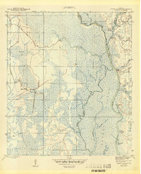
 1945 Orange1945 Print · USGSThe Florida panhandle river country comes into focus during the mid-forties as the river and forest dominate the border of Liberty and Calhoun counties. Researchers can trace historic river access at Gunn Landing, locate the Orange Cem, and explore the swampy terrain around Larkin Fish Camp.4 unique versions available
 - 1945 Map of Allanton
 1945 Allanton1945 Print · USGSCoastal Florida near the end of the Second World War was a landscape of intricate bayous and small fishing settlements. You can trace the early footprints of Allanton and Farmdale along the shores of East Bay and the Wetappo Intracoastal Waterway Creek.3 unique versions available
 - 1945 Map of North Of Allanton
 1945 North Of Allanton1945 Print · USGSBay County's dense swamp and bayou country is recorded here in the mid-1940s, showing a landscape defined by timber and tide. Researchers can locate the Kent Cem and trace the early route of Allanton Road past the Majette Fire Tower.3 unique versions available
 - 1945 Map of Wewahitchka
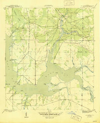
 1945 Wewahitchka1945 Print · USGSGulf County river life in the mid-1940s centered on the confluence of the Chipola and Apalachicola. Researchers can trace historic river access at Cockran Landing or locate family roots in settlements like Wewahitchka, Honeyville, and Dalkeith.4 unique versions available
 - 1945 Map of Wetappo Creek
 1945 Wetappo Creek1945 Print · USGSThe Florida Panhandle's marshy lowlands are captured here in the mid-1940s, just as modern drainage and navigation projects reshaped the coast. Researchers can trace the early path of the Intracoastal Waterway and locate the isolated Wetappo Side Camp near Jersey Islands.4 unique versions available
 - 1945 Map of Jackson River
 1945 Jackson River1945 Print · USGSThe Apalachicola delta and Gulf Coast wetlands are mapped here in the final year of the war, showing a landscape of tidal creeks and river islands. Researchers can trace remote sites like Box R Ranch, the waters of Lake Wimico, and the tiny settlement at Bay City.4 unique versions available
 - 1945 Map of Indian Pass
 1945 Indian Pass1945 Print · USGSThe Florida coast near Indian Pass is documented here during the mid-1940s, showing a landscape of barrier islands and vital coastal infrastructure. Trace the early settlements at Eleven Mile and Odena, or locate the Coast Guard Sta No 105 and Odena Fire Tower 9.4 unique versions available
 - 1945 Map of St Joseph Point
 1945 St Joseph Point1945 Print · USGSThe Florida Panhandle shoreline remains largely untouched in the mid-forties, defined by the narrow strip of the Spit. Researchers can examine the precise natural contours of St Joseph Pt and the sheltered anchorage at Eagle Harbor.4 unique versions available
 - 1945 Map of Tenmile Swamp
 1945 Tenmile Swamp1945 Print · USGSGulf County and Calhoun County are captured here just after the war, showing a landscape defined by its complex hydrologic network. Genealogists and researchers can trace the vicinity of the Wetappo Forest Ranger Sta and land features like Two Pen Ridge or Stone Mill Creek.4 unique versions available
 - 1947 Map of Allanton
 1947 Allanton1947 Print · USGSThe Florida Panhandle coast near East Bay is shown here in the late 1940s, just as the regional waterway system was maturing. Historians can trace the early footprints of Allanton and Farmdale or follow the route of the Wetappo Intracoastal Waterway.
 - 1949 Map of Apalachicola
 1949 Apalachicola1949 Print · USGSThe Florida Panhandle's Forgotten Coast is captured mid-century, showcasing the intricate web of swamps, sounds, and barrier islands. Genealogists and historians can trace the Apalachicola Northern rail line and locate old landmarks like Fort Gadsden or the St Joe Fire Tower.
Showing maps 1-25 of 161
Top cities of Gulf County
Frequently asked questions
- What are the different types of historical maps available for Gulf County?
- What is the oldest map of Gulf County?
- Where can I purchase historical maps of Gulf County for my home or office?
- Where can I download high-res historical maps of Gulf County?
- Are there historical topographic maps available for Gulf County?
- Is there historical aerial imagery available for Gulf County?
- Where are historical maps of Gulf County sourced from?