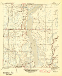
1945 Map of Dead Lake
USGS Topo · Published 1945This historical map portrays the area of Dead Lake in 1945, primarily covering Gulf County as well as portions of Calhoun County and Liberty County. Featuring a scale of 1:31680, this map provides a highly detailed snapshot of the terrain, roads, buildings, counties, and historical landmarks in the Dead Lake region at the time. Published in 1945, it is one of 4 known editions of this map due to revisions or reprints.
Find a feature on this map
15 named features on this map. Tap any name to fly to it.
Don’t see what you’re looking for? This feature index may not catch every label — zoom into the map to look around manually.
Map Details
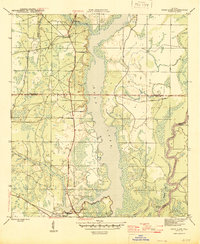
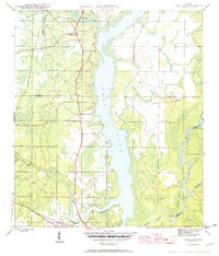
Editions of this 1945 Dead Lake Map
4 editions found
Historical Maps of Gulf County Through Time
27 maps found

1943 Cape San Blas
Gulf County, FL

1943 Jackson River
Gulf County, FL

1943 Overstreet
Gulf County, FL

1943 St. Joseph Spit
Gulf County, FL

1944 Forbes Island
Gulf County, FL

1944 White City
Gulf County, FL

1945 Dead Lake
Gulf County, FL

1945 Forbes Island
Gulf County, FL

1945 Jackson River
Gulf County, FL

1945 Lake Wimico
Gulf County, FL

1945 St. Joseph Point
Gulf County, FL

1945 Tenmile Swamp
Gulf County, FL

1945 Wetappo Creek
Gulf County, FL

1945 White City
Gulf County, FL

1978 Port Saint Joe
Gulf County, FL

1982 Cape San Blas
Gulf County, FL

1982 Forbes Island
Gulf County, FL

1982 Jackson River
Gulf County, FL

1982 Lake Wimico
Gulf County, FL

1982 Overstreet
Gulf County, FL

1982 St. Joseph Peninsula
Gulf County, FL

1982 St Joseph Point
Gulf County, FL

1982 Tenmile Swamp
Gulf County, FL

1982 Wetappo Creek
Gulf County, FL

1982 White City
Gulf County, FL

1990 Dead Lakes
Gulf County, FL

1994 Wetappo Creek
Gulf County, FL