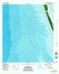
1982 Map of St. Joseph Peninsula
USGS Topo · Published 1983About this map
St Joseph Peninsula stretches across this 1982 orthophotomap, forming a protective barrier between the Gulf of Mexico and the calm waters of St Joseph Bay. This unique study combines aerial photography with bathymetric data, offering a detailed look at the underwater topography and the shifting sands of the Florida Panhandle coastline. Significant portions of the landscape are dedicated to conservation, including the Saint Joseph Peninsula State Park at the northern tip and the neighboring Saint Vincent NWR across the channel. The map highlights the dynamic nature of this environment, specifically noting an area subject to frequent change along the bay-side shoreline. Inland, the narrow strip of land is punctuated by natural features like Pig Bayou, while a lone reference point, Joseph 1959, provides a fixed marker for surveyors and historians tracking the evolution of this delicate coastal spit.
Find a feature on this map
9 named features on this map. Tap any name to fly to it.
Don’t see what you’re looking for? This feature index may not catch every label — zoom into the map to look around manually.
Map Details
Editions of this 1982 St. Joseph Peninsula Map
This is the sole edition of this map. No revisions or reprints were ever made.
Other maps of this area

1943 · St Joseph Spit
USGS Topo · 1:31,680

1943 · Port St. Joe
USGS Topo · 1:31,680

1943 · Cape San Blas
USGS Topo · 1:31,680

1945 · St Joseph Point
USGS Topo · 1:31,680

1949 · Apalachicola
USGS Topo · 1:250,000

1957 · Apalachicola
USGS Topo · 1:250,000

1959 · Apalachicola
USGS Topo · 1:250,000
1960 · Apalachicola
USGS Topo · 1:250,000
1967 · Apalachicola
USGS Topo · 1:250,000
1978 · Port Saint Joe
USGS Topo · 1:100,000