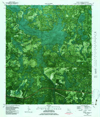
1982 Map of Tenmile Swamp
USGS Topo · Published 1983About this map
Tenmile Swamp dominates the center of this 1980s orthophotomat, a hybrid map style that uses aerial photography to depict the dense wetlands of Gulf and Calhoun counties. The landscape is a network of water and timber, defined by winding waterways like Stone Mill Creek, Little Bear Creek, and the man-made Willie Goodman Cutoff that navigates through the swampy interior. Settlement is sparse, with human presence marked primarily by a Landing Strip and isolated Jeep Trails cutting through the vegetation.
Find a feature on this map
22 named features on this map. Tap any name to fly to it.
Don’t see what you’re looking for? This feature index may not catch every label — zoom into the map to look around manually.
Map Details
Editions of this 1982 Tenmile Swamp Map
This is the sole edition of this map. No revisions or reprints were ever made.
Other maps of this area

1945 · Dead Lake
USGS Topo · 1:31,680

1945 · Youngstown
USGS Topo · 1:31,680

1945 · Broad Branch
USGS Topo · 1:31,680

1945 · Allanton
USGS Topo · 1:31,680

1945 · North Of Allanton
USGS Topo · 1:31,680

1945 · Frink
USGS Topo · 1:31,680

1945 · Wewahitchka
USGS Topo · 1:31,680

1945 · Wetappo Creek
USGS Topo · 1:31,680

1945 · Tenmile Swamp
USGS Topo · 1:31,680

1947 · Allanton
USGS Topo · 1:25,000