1900s (20th Century) Maps of Zolfo Springs, Florida
Explore 8 historic maps of Zolfo Springs from the 1900s (20th Century). These maps offer a rare glimpse into what life looked like during the 1900s — showing old roads, neighborhoods, homes, and landmarks that have changed or disappeared over time.
Whether you're researching your family's past, planning a metal detecting trip, or studying how Zolfo Springs's landscape evolved across the 1900s, these high-resolution maps are a powerful tool for exploring the history of this region.
- Focus on a specific era: All maps on this page are from the 1900s, giving you a focused view of this time period.
- See what’s changed: Compare century-old streets, trails, and buildings to today's modern landscape using overlays and satellite layers.
- Research with precision: Use these maps for genealogy, historical research, land use analysis, or educational projects.
- View, download, or print: Maps are fully viewable online in high resolution, and can be downloaded or printed for your own records.
Start exploring Zolfo Springs's history through authentic maps from the 1900s. This is your window into the past.
Zolfo Springs, FL maps
(8)- 1955 Map of Wauchula, 1956 Print
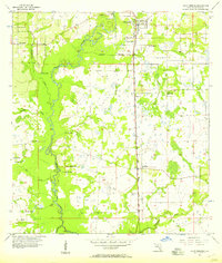
 1955 Wauchula1956 Print · USGSMid-century Hardee County comes alive in this survey of the citrus and rail corridor along the Peace River. Researchers can trace the original street layout of Wauchula and find local landmarks like Wauchula Cem and Lake Dale Ch.4 unique versions available
 - 1956 Map of Zolfo Springs, 1957 Print
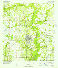
 1956 Zolfo Springs1957 Print · USGSHardee County in the mid-1950s is defined here by the winding Peace River and the transit corridor of the Atlantic Coast Line. Genealogists and historians can trace old settlements at Oak Grove and Moffitt, or locate community centers like Friendship Church.3 unique versions available
 - 1956 Map of Fort Pierce, 1965 Print
 1956 Fort Pierce1965 Print · USGSCentral and coastal Florida appear here during a period of rapid post-war growth and industrial expansion. Researchers can trace the mid-century rail-to-highway transition along the Sunshine State Parkway or locate old settlements like Ankona, Walton, and Indrio.4 unique versions available
 - 1958 Map of Fort Pierce
 1958 Fort Pierce1958 Print · USGSCentral and South Florida are captured here in the late fifties as the citrus and ranching interior met the modern highway era. Researchers can trace the early path of the Sunshine State Parkway and locate established rail depots in Sebring, Okeechobee, and Arcadia.
 - 1959 Map of Fort Pierce
 1959 Fort Pierce1959 Print · USGSCentral Florida and the Treasure Coast are shown here in the late fifties, during a period of steady citrus and coastal growth. Trace the historic routes of the Florida East Coast Ry or locate the boundaries of the Seminole Indian Reservation and Highlands Hammock State Park.3 unique versions available
 - 1978 Map of Arcadia, 1980 Print
 1978 Arcadia1980 Print · USGSDeSoto and Highlands counties are shown here in the late seventies, a landscape defined by the Peace River and extensive citrus groves. Genealogists and researchers can trace the SEABOARD COAST LINE railroad through old settlements like Nocatee, Zolfo Springs, and Fort Ogden.
 - 1978 Map of Bartow, 1980 Print
 1978 Bartow1980 Print · USGSCentral Florida during the late seventies was a landscape of industrial phosphate mines and expansive lake systems. Trace the legacy of the Seaboard Coast Line as it connects Fort Meade, Wauchula, and the massive Avon Park Bombing Range.2 unique versions available
 - 1988 Map of Fort Pierce
 1988 Fort Pierce1988 Print · USGSThe Atlantic coast and Florida’s interior lakelands are captured in the late eighties, just as the Treasure Coast was experiencing rapid development. Genealogists and historians can trace the rail lines of the Florida East Coast and explore the bounds of the Brighton Indian Reservation.
End of results
Showing maps 1-8 of 8
Top cities near Zolfo Springs
Frequently asked questions
- What are the different types of historical maps available for Zolfo Springs?
- What is the oldest map of Zolfo Springs?
- Where can I purchase historical maps of Zolfo Springs for my home or office?
- Where can I download high-res historical maps of Zolfo Springs?
- Are there historical topographic maps available for Zolfo Springs?
- Is there historical aerial imagery available for Zolfo Springs?
- Where are historical maps of Zolfo Springs sourced from?