1990s Maps of Palma Ceia Pines, Tampa
Explore 2 historic maps of Palma Ceia Pines from the 1990s. These maps offer a rare glimpse into what life looked like during the 1990s — showing old roads, neighborhoods, homes, and landmarks that have changed or disappeared over time.
Whether you're researching your family's past, planning a metal detecting trip, or studying how Palma Ceia Pines's landscape evolved across the 1990s, these high-resolution maps are a powerful tool for exploring the history of this region.
- Focus on a specific era: All maps on this page are from the 1990s, giving you a focused view of this time period.
- See what’s changed: Compare century-old streets, trails, and buildings to today's modern landscape using overlays and satellite layers.
- Research with precision: Use these maps for genealogy, historical research, land use analysis, or educational projects.
- View, download, or print: Maps are fully viewable online in high resolution, and can be downloaded or printed for your own records.
Start exploring Palma Ceia Pines's history through authentic maps from the 1990s. This is your window into the past.
Palma Ceia Pines, Tampa maps
- 1995 Map of Tampa, 1999 Print
 1995 Tampa1999 Print · USGSTampa's maritime and industrial landscape is captured here during the mid-nineties, showing a city deeply tied to its waterfront and rail lines. You can trace the development of Ybor City, locate numerous historic burial grounds like Myrtle Hill Cemetery, and explore the rail operations at Uceta Yard.
 - 1998 Map of Gandy Bridge, 2002 Print
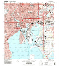
 1998 Gandy Bridge2002 Print · USGSTampa and the Interbay Peninsula are shown in the late nineties as a fully integrated hub of aviation and coastal transit. Genealogists and local historians can trace the development of neighborhood schools like Plant High Sch or locate the American Legion Cem and Drew Park.
End of results
Showing maps 1-2
Frequently asked questions
- What are the different types of historical maps available for Palma Ceia Pines?
- What is the oldest map of Palma Ceia Pines?
- Where can I purchase historical maps of Palma Ceia Pines for my home or office?
- Where can I download high-res historical maps of Palma Ceia Pines?
- Are there historical topographic maps available for Palma Ceia Pines?
- Is there historical aerial imagery available for Palma Ceia Pines?
- Where are historical maps of Palma Ceia Pines sourced from?