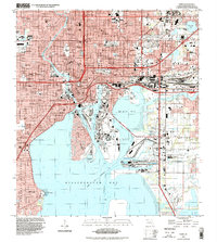
1995 Map of Tampa
USGS Topo · Published 1999About this map
The industrial and maritime heart of Tampa is laid bare in this late 20th-century survey, showcasing a complex network of shipping channels and rail infrastructure. The Hillsborough River cuts through the urban center, meeting the deep-water corridors of the Ybor Channel, Sparkman Channel, and Garrison Channel that surround Harbour Island. To the south, the aviation history of Davis Islands is anchored by the Peter O Knight Airport, while the eastern landscape is dominated by the sprawling Uceta Yard of the Seaboard System railroad.
Find a feature on this map
89 named features on this map. Tap any name to fly to it.
Don’t see what you’re looking for? This feature index may not catch every label — zoom into the map to look around manually.
Map Details
Editions of this 1995 Tampa Map
This is the sole edition of this map. No revisions or reprints were ever made.
Other maps of this area

1921 · Tampa
USGS Topo · 1:62,500

1921 · St Petersburg
USGS Topo · 1:62,500

1943 · Gandy Bridge
USGS Topo · 1:31,680

1943 · Port Tampa
USGS Topo · 1:31,680

1943 · Thonotosassa
USGS Topo · 1:24,000

1944 · Sulphur Springs
USGS Topo · 1:31,680

1944 · Mango
USGS Topo · 1:31,680

1944 · Tampa
USGS Topo · 1:31,680

1944 · Thonotosassa
USGS Topo · 1:31,680

1944 · Balm
USGS Topo · 1:31,680