1990s Maps of Jackson County, Florida
Explore 18 historic maps of Jackson County from the 1990s. These maps offer a rare glimpse into what life looked like during the 1990s — showing old roads, neighborhoods, homes, and landmarks that have changed or disappeared over time.
Whether you're researching your family's past, planning a metal detecting trip, or studying how Jackson County's landscape evolved across the 1990s, these high-resolution maps are a powerful tool for exploring the history of this region.
- Focus on a specific era: All maps on this page are from the 1990s, giving you a focused view of this time period.
- See what’s changed: Compare century-old streets, trails, and buildings to today's modern landscape using overlays and satellite layers.
- Research with precision: Use these maps for genealogy, historical research, land use analysis, or educational projects.
- View, download, or print: Maps are fully viewable online in high resolution, and can be downloaded or printed for your own records.
Start exploring Jackson County's history through authentic maps from the 1990s. This is your window into the past.
Jackson County, FL maps
(18)- 1994 Map of Alford, 1995 Print
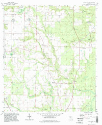
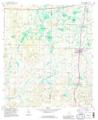 1994 Alford1995 Print · USGSIn the mid-1990s, the Jackson County panhandle retained a landscape of rural crossroads and numerous distinct wetland bays. Genealogists and researchers can locate several country churches and burial grounds, including Macedonia Ch, Sweet Gum Ch, and Kent Cem.
 - 1994 Map of Cottondale West, 1995 Print
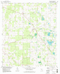
 1994 Cottondale West1995 Print · USGSThe borderlands of Jackson and Washington counties come to life in the mid-1990s, showing a landscape of rural crossroads and persistent wetlands. Researchers can trace family history through local landmarks like Glass Ch, Lovewood, and the Cottondale Airport.
 - 1994 Map of Compass Lake, 1995 Print
 1994 Compass Lake1995 Print · USGSThe Florida Panhandle's lake-dotted interior is captured here in the mid-1990s, revealing a landscape of rural communities and intricate county boundaries. Genealogists and historians can trace local landmarks like Betts, Sandy Mountain Church, and the waters of Hammond Lake.
 - 1994 Map of Marianna, 1995 Print
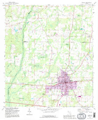
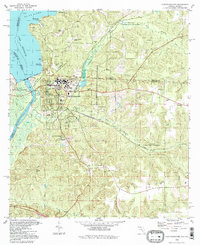
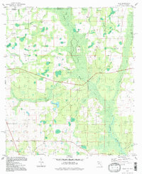
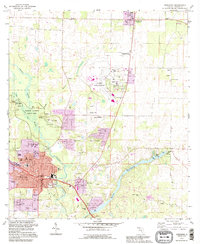 1994 Marianna1995 Print · USGSMarianna and the Chipola River valley are captured in the mid-1990s, showcasing a mix of state parklands and growing Panhandle neighborhoods. Genealogists and historians can trace numerous rural burial sites like Orange Hill Cem and old landmarks like Greenwood Chapel.
 - 1994 Map of Cottondale East, 1995 Print
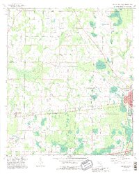
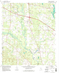
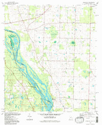
 1994 Cottondale East1995 Print · USGSJackson County in the mid-nineties shows the evolving landscape between the growing town of Marianna and the rural crossroads of Cottondale. Genealogists can trace old family sites near Speights Cem, the historic Bellamy Bridge, or the riverside Christoff Ferry Landing.
 - 1994 Map of Chipley, 1995 Print
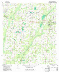
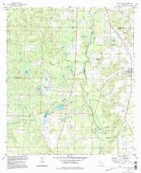
 1994 Chipley1995 Print · USGSNorthwest Florida's tri-county borderlands come into focus in the mid-nineties, centered on the growing seat of Chipley. Researchers can trace local landmarks like Glenwood Cem, the old Drive-in Theater, and small settlements such as Richter Crossroads.
 - 1994 Map of Graceville, 1998 Print
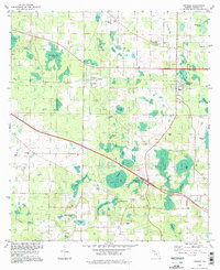
 1994 Graceville1998 Print · USGSGraceville and the Alabama state line are captured in the late twentieth century, showing a rural landscape defined by rail crossings and cypress bays. Genealogists can locate family landmarks like Murphy Hill, Collins Mill, and country churches such as Damascus Ch.
 - 1994 Map of Bascom, 1998 Print
 1994 Bascom1998 Print · USGSThe Chattahoochee River borderlands come into focus in the 1990s, revealing a landscape of rural junctions and abundant wetlands. Genealogists and historians can locate family landmarks like Bazzell Cem and Shiloh Ch alongside the decommissioned Auxiliary Field No 3.
 - 1994 Map of Sneads, 1998 Print
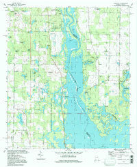
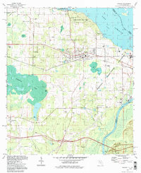 1994 Sneads1998 Print · USGSJackson County, Florida, is captured here in the 1990s as a vital crossroads of river commerce and state conservation. Researchers can trace historic family burial sites and local congregations including Sardis Cem, St Peter Cem, and Sinai Ch.
 - 1994 Map of Altha East, 1998 Print
 1994 Altha East1998 Print · USGSThe Florida Panhandle's rural landscape is preserved here as it appeared in the 1990s, split by the Jackson and Calhoun county line. Genealogists and local historians can trace family roots through numerous sites like Ocheesee Cem, Corinth Ch, and the settlement at Alliance.
 - 1994 Map of Oakdale, 1998 Print
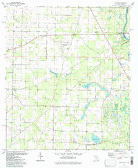
 1994 Oakdale1998 Print · USGSJackson County rural life during the 1990s is centered here on the Chipola River and its surrounding wetlands. Genealogists can trace family heritage through local landmarks like Jerusalem Cem, Hope Sch, and the small settlement of Simsville.
 - 1994 Map of Cypress, 1998 Print
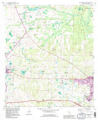
 1994 Cypress1998 Print · USGSJackson County in the 1990s remained a landscape of quiet crossroads and extensive wetlands. Researchers can trace family history through numerous small burial grounds like Stephens Cem or locate rural centers such as Grand Ridge and Cypress.
 - 1994 Map of Altha West, 1998 Print
 1994 Altha West1998 Print · USGSThe Chipola River corridor near Altha comes into focus during the late twentieth century as timber and water define local life. Researchers can locate numerous rural burial grounds and churches, including Edenfield Cem, Shiloh Cem, and the Old Railroad Grade.
 - 1994 Map of Fairchild, 1998 Print
 1994 Fairchild1998 Print · USGSThe Georgia-Florida borderlands come to life in the 1990s as the river landscape shifts between recreation and old riverfront settlements. Genealogists and historians can trace family roots at Fairchild Cem or explore the river's edge at Butlers Ferry Landing and Parramore Landing.
 - 1994 Map of Chattahoochee, 1998 Print
 1994 Chattahoochee1998 Print · USGSChattahoochee and the Florida-Georgia border are captured here in the mid-1990s at the critical junction of the Flint and Apalachicola Rivers. Researchers can trace institutional history at the Florida State Hospital or locate family sites like White Cem and Hardin Heights.
 - 1994 Map of Dellwood, 1998 Print
 1994 Dellwood1998 Print · USGSJackson County in the nineties remains a landscape of traditional Florida Panhandle settlements and numerous natural karst ponds. You can trace family roots at Two Egg, find the McNealy Cem, and locate rural landmarks like New Hope Ch.
 - 1994 Map of Steam Mill, 1998 Print
 1994 Steam Mill1998 Print · USGSThe Georgia and Florida borderlands are captured here in the mid-nineties as the river economy gave way to conservation and lake life. Genealogists can trace family footprints at Lela Courthouse and numerous burial sites like Brunson Cem or Williams Cem.
 - 1994 Map of Sills, 1998 Print
 1994 Sills1998 Print · USGSJackson County and the Alabama borderlands are captured here in the 1990s, showing a landscape defined by the Chipola River. Researchers can trace rural lineages through local landmarks like Holyneck Ch, Moulten Cem, and the historic settlement at Sills.
End of results
Showing maps 1-18 of 18
Top cities of Jackson County
- Marianna historical maps
- Graceville historical maps
- Malone historical maps
- Sneads historical maps
- Cottondale historical maps
- Grand Ridge historical maps
See more
Frequently asked questions
- What are the different types of historical maps available for Jackson County?
- What is the oldest map of Jackson County?
- Where can I purchase historical maps of Jackson County for my home or office?
- Where can I download high-res historical maps of Jackson County?
- Are there historical topographic maps available for Jackson County?
- Is there historical aerial imagery available for Jackson County?
- Where are historical maps of Jackson County sourced from?