1900s (20th Century) Maps of Jacob City, Florida
Explore 10 historic maps of Jacob City from the 1900s (20th Century). These maps offer a rare glimpse into what life looked like during the 1900s — showing old roads, neighborhoods, homes, and landmarks that have changed or disappeared over time.
Whether you're researching your family's past, planning a metal detecting trip, or studying how Jacob City's landscape evolved across the 1900s, these high-resolution maps are a powerful tool for exploring the history of this region.
- Focus on a specific era: All maps on this page are from the 1900s, giving you a focused view of this time period.
- See what’s changed: Compare century-old streets, trails, and buildings to today's modern landscape using overlays and satellite layers.
- Research with precision: Use these maps for genealogy, historical research, land use analysis, or educational projects.
- View, download, or print: Maps are fully viewable online in high resolution, and can be downloaded or printed for your own records.
Start exploring Jacob City's history through authentic maps from the 1900s. This is your window into the past.
Jacob City, FL maps
(10)- 1952 Map of Campbellton, 1953 Print
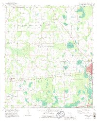
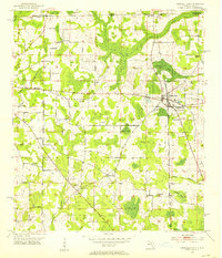 1952 Campbellton1953 Print · USGSJackson County and the Florida-Alabama border are captured here in the early fifties, centered on the rail-fed hub of Campbellton. Genealogists can trace rural community life through numerous local landmarks like Hinson Cem, Shiloh Sch, and Ellaville.2 unique versions available
 - 1952 Map of Cottondale West, 1953 Print
 1952 Cottondale West1953 Print · USGSJackson County's railroad and rural church networks are preserved here in the early 1950s, centered on the strategic rail junction at Cottondale. Genealogists and local historians can trace family roots through landmarks like Lovewood Sch, Pilgrim Rest Ch, and New Prospect Ch.2 unique versions available
 - 1954 Map of Tallahassee, 1967 Print
 1954 Tallahassee1967 Print · USGSThe Florida Panhandle and South Georgia are captured here during a period of mid-century growth and military expansion. Researchers can trace the development of Panama City, the footprint of Tyndall Air Force Base, and the rail lines of the Atlantic Coast Line.4 unique versions available
 - 1959 Map of Tallahassee
 1959 Tallahassee1959 Print · USGSFlorida's Panhandle and the Big Bend region appear here in the mid-fifties, showing a landscape defined by its great river systems and developing coast. Trace the early layout of Panama City, the expansive Apalachicola National Forest, and the coastal St Marks Lighthouse.
 - 1960 Map of Tallahassee
 1960 Tallahassee1960 Print · USGSThe Florida Panhandle and southern Georgia are captured here in the mid-twentieth century, showing a region defined by its rivers and military installations. Genealogists and historians can trace the growth of Tallahassee or locate coastal landmarks like the St Marks Lighthouse and Tyndall Air Force Base.
 - 1979 Map of Marianna, 1980 Print
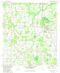
 1979 Marianna1980 Print · USGSFlorida's northern panhandle and the neighboring Alabama-Georgia borderlands are captured here in the late seventies. Genealogists and local historians can trace family roots through settlements like Graceville and Cottondale or follow the historic Louisville and Nashville rail lines.2 unique versions available
 - 1982 Map of Campbellton
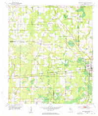
 1982 Campbellton1982 Print · USGSJackson County and the Florida-Alabama border appear here in the early eighties as a landscape of crossroads settlements and small-town junctions. Genealogists can trace family landmarks like Hinson Cem and Salem Ch along the Atlanta and Saint Andrews Bay rail line.2 unique versions available
 - 1982 Map of Cottondale West, 1983 Print
 1982 Cottondale West1983 Print · USGSThe Florida Panhandle's rail and timber landscape is well-preserved here in the early eighties, showing the junction of the Louisville and Nashville and Atlanta and St Andrews Bay lines. Researchers can trace rural church history at Pilgrim Rest Ch or locate family landmarks like Gilberts Mill Creek and Still Hammock.
 - 1988 Map of Tallahassee
 1988 Tallahassee1988 Print · USGSThe Florida Panhandle and South Georgia are captured here in the late eighties, showing the expansion of the regional highway network and coastal growth. Genealogists and historians can trace rail lines like the Seaboard System Railroad or locate family roots in Blountstown, Graceville, or Crawfordville.2 unique versions available
 - 1994 Map of Cottondale West, 1995 Print
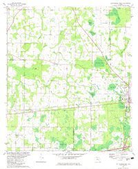
 1994 Cottondale West1995 Print · USGSThe borderlands of Jackson and Washington counties come to life in the mid-1990s, showing a landscape of rural crossroads and persistent wetlands. Researchers can trace family history through local landmarks like Glass Ch, Lovewood, and the Cottondale Airport.
End of results
Showing maps 1-10 of 10
Top cities near Jacob City
- Marianna historical maps
- Chipley historical maps
- Graceville historical maps
- Slocomb historical maps
- Rehobeth historical maps
- Malvern historical maps
See more
Frequently asked questions
- What are the different types of historical maps available for Jacob City?
- What is the oldest map of Jacob City?
- Where can I purchase historical maps of Jacob City for my home or office?
- Where can I download high-res historical maps of Jacob City?
- Are there historical topographic maps available for Jacob City?
- Is there historical aerial imagery available for Jacob City?
- Where are historical maps of Jacob City sourced from?