1970s Maps of Lafayette County, Florida
Explore 2 historic maps of Lafayette County from the 1970s. These maps offer a rare glimpse into what life looked like during the 1970s — showing old roads, neighborhoods, homes, and landmarks that have changed or disappeared over time.
Whether you're researching your family's past, planning a metal detecting trip, or studying how Lafayette County's landscape evolved across the 1970s, these high-resolution maps are a powerful tool for exploring the history of this region.
- Focus on a specific era: All maps on this page are from the 1970s, giving you a focused view of this time period.
- See what’s changed: Compare century-old streets, trails, and buildings to today's modern landscape using overlays and satellite layers.
- Research with precision: Use these maps for genealogy, historical research, land use analysis, or educational projects.
- View, download, or print: Maps are fully viewable online in high resolution, and can be downloaded or printed for your own records.
Start exploring Lafayette County's history through authentic maps from the 1970s. This is your window into the past.
Lafayette County, FL maps
(2)- 1978 Map of Cross City, 1980 Print
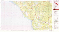 1978 Cross City1980 Print · USGSThe Florida Big Bend's coastal swamps and timberlands are captured here in the late seventies. Researchers can trace the path of the Seaboard Coast Line through Cross City or locate old coastal spots like Fishermans Rest and Clara.2 unique versions available
 - 1979 Map of Perry, 1980 Print
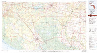 1979 Perry1980 Print · USGSThe Florida Big Bend and Suwannee River valley are captured here in the late seventies during a period of established timber and rail activity. Genealogists and historians can trace the Live Oak Perry and South Georgia line through Scanlon or locate family roots in Dowling Park and Greenville.2 unique versions available
End of results
Showing maps 1-2 of 2
Top cities of Lafayette County
Frequently asked questions
- What are the different types of historical maps available for Lafayette County?
- What is the oldest map of Lafayette County?
- Where can I purchase historical maps of Lafayette County for my home or office?
- Where can I download high-res historical maps of Lafayette County?
- Are there historical topographic maps available for Lafayette County?
- Is there historical aerial imagery available for Lafayette County?
- Where are historical maps of Lafayette County sourced from?