1950s Maps of Lake County, Florida
Explore 9 historic maps of Lake County from the 1950s. These maps offer a rare glimpse into what life looked like during the 1950s — showing old roads, neighborhoods, homes, and landmarks that have changed or disappeared over time.
Whether you're researching your family's past, planning a metal detecting trip, or studying how Lake County's landscape evolved across the 1950s, these high-resolution maps are a powerful tool for exploring the history of this region.
- Focus on a specific era: All maps on this page are from the 1950s, giving you a focused view of this time period.
- See what’s changed: Compare century-old streets, trails, and buildings to today's modern landscape using overlays and satellite layers.
- Research with precision: Use these maps for genealogy, historical research, land use analysis, or educational projects.
- View, download, or print: Maps are fully viewable online in high resolution, and can be downloaded or printed for your own records.
Start exploring Lake County's history through authentic maps from the 1950s. This is your window into the past.
Lake County, FL maps
(9)- 1954 Map of Daytona Beach, 1974 Print
 1954 Daytona Beach1974 Print · USGSNortheast Florida is captured in the mid-1950s, showing the transition from river-based commerce to coastal tourism. Researchers can trace the Florida East Coast rail lines and find historic sites like Castillo de San Marcos Nat Mon and Palatka.
 - 1955 Map of Orlando, 1969 Print
 1955 Orlando1969 Print · USGSCentral Florida was entering the space age in the mid-fifties, balancing its citrus heritage with new military and aerospace frontiers. You can trace early developments at Kennedy Space Center or locate interior settlements like Eatonville and Pine Castle.3 unique versions available
 - 1957 Map of Orlando
 1957 Orlando1957 Print · USGSCovers Lake County, including Orlando, Palm Bay, and other nearby areas
 - 1958 Map of Orlando
 1958 Orlando1958 Print · USGSCentral Florida was a landscape of citrus, rail, and emerging aerospace technology during the late fifties. Researchers can trace the early footprints of Cape Canaveral and Patrick Air Force Base or locate inland citrus and rail hubs like Sanford and Lakeland.
 - 1958 Map of Daytona Beach
 1958 Daytona Beach1958 Print · USGSThe Florida coast and St. Johns River valley are captured in the late 1950s, showing a landscape defined by citrus-belt rail towns and Atlantic shorelines. Genealogists can trace family roots through riverside settlements like Palatka and Welaka or coastal hubs like Daytona Beach.2 unique versions available
 - 1959 Map of Lake Nellie, 1960 Print
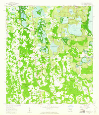 1959 Lake Nellie1960 Print · USGSCentral Florida’s wetlands are captured here in the late fifties, showcasing the intricate water systems of the Green Swamp. Researchers can trace the early footprint of South Clermont and locate family-named landmarks like Joe Lee Island or Black Jack Island.4 unique versions available
 - 1959 Map of Lake Louisa, 1960 Print
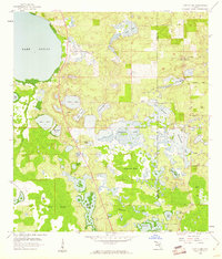 1959 Lake Louisa1960 Print · USGSLake and Orange Counties were defined by vast wetlands and remote citrus-access roads during the late fifties. Researchers can trace the early footprints of Tiger Island, the Avalon Lookout Tower, and the winding path of Old YMCA Road.3 unique versions available
 - 1959 Map of Lake Louisa SW, 1960 Print
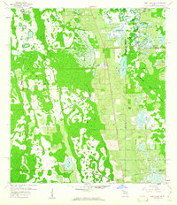 1959 Lake Louisa SW1960 Print · USGSCentral Florida's interior was a complex network of wetlands and cypress strands in the late fifties, long before the region's theme park boom. Trace the paths of the Old Tram Road and Dean Still Road past Lake Davenport and Oak Island.7 unique versions available
 - 1959 Map of Poyner, 1960 Print
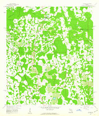 1959 Poyner1960 Print · USGSCentral Florida's citrus and timber country comes alive in the late fifties as the Seaboard Air Line Railroad cuts through the marshlands. Genealogists and historians can trace old settlements like Eva and Poyner, or locate the Green Pond Ch.4 unique versions available
End of results
Showing maps 1-9 of 9
Top cities of Lake County
- Four Corners historical maps
- Clermont historical maps
- Leesburg historical maps
- Eustis historical maps
- Tavares historical maps
- Groveland historical maps
See more
Frequently asked questions
- What are the different types of historical maps available for Lake County?
- What is the oldest map of Lake County?
- Where can I purchase historical maps of Lake County for my home or office?
- Where can I download high-res historical maps of Lake County?
- Are there historical topographic maps available for Lake County?
- Is there historical aerial imagery available for Lake County?
- Where are historical maps of Lake County sourced from?