1970s Maps of Lake County, Florida
Explore 8 historic maps of Lake County from the 1970s. These maps offer a rare glimpse into what life looked like during the 1970s — showing old roads, neighborhoods, homes, and landmarks that have changed or disappeared over time.
Whether you're researching your family's past, planning a metal detecting trip, or studying how Lake County's landscape evolved across the 1970s, these high-resolution maps are a powerful tool for exploring the history of this region.
- Focus on a specific era: All maps on this page are from the 1970s, giving you a focused view of this time period.
- See what’s changed: Compare century-old streets, trails, and buildings to today's modern landscape using overlays and satellite layers.
- Research with precision: Use these maps for genealogy, historical research, land use analysis, or educational projects.
- View, download, or print: Maps are fully viewable online in high resolution, and can be downloaded or printed for your own records.
Start exploring Lake County's history through authentic maps from the 1970s. This is your window into the past.
Lake County, FL maps
(8)- 1970 Map of Salt Springs, 1973 Print
 1970 Salt Springs1973 Print · USGSThe Marion County wetlands and Ocala backcountry come alive in the early 1970s, showcasing a landscape of spring runs and vast prairies. Genealogists and historians can trace the paths around Salt Springs, the shores of Lake George, and remote sites like Hopkins Prairie.2 unique versions available
 - 1972 Map of Juniper Springs, 1973 Print
 1972 Juniper Springs1973 Print · USGSThe Ocala National Forest in the early seventies reveals a landscape of artesian springs and restricted military territory. Researchers can trace the boundaries of the U S Naval Reservation and locate historic recreation sites like Fern Hammock Springs and Juniper Prairie.3 unique versions available
 - 1972 Map of Farles Lake, 1973 Print
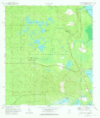
 1972 Farles Lake1973 Print · USGSMarion and Lake counties in the early 1970s reveal a landscape of dense timber and hidden waters within the Ocala National Forest. Researchers can trace the Old Railroad Grade or locate early facilities like Camp Ocala and the Pittman Work Center.2 unique versions available
 - 1972 Map of Astor, 1973 Print
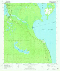
 1972 Astor1973 Print · USGSThe St. Johns River corridor and Ocala National Forest appear here in the early 1970s, showcasing a landscape of river-fronting settlements and dense wetlands. Researchers can trace the Old Railroad Grade near Astor Park or locate the site of Camp McQuarrie among the numerous interior lakes.3 unique versions available
 - 1972 Map of Alexander Springs, 1973 Print
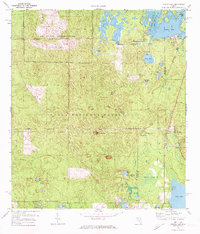
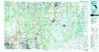
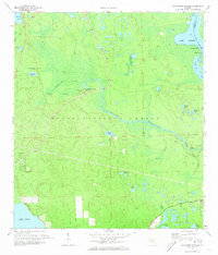 1972 Alexander Springs1973 Print · USGSIn the early seventies, the Lake County wilderness within the Ocala National Forest remained a landscape defined by water and woods. Genealogists and historians can locate Shackley Cem or trace the winding St Johns River past Bowers Bluff.
 - 1978 Map of Daytona Beach, 1980 Print
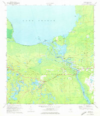
 1978 Daytona Beach1980 Print · USGSCoastal development meets the wild Florida interior in the late seventies, spanning from the Atlantic beaches to the St. Johns River. Trace the growth of Daytona Beach or find inland outposts like Salt Springs, De Leon Springs, and the U S Naval Reservation.2 unique versions available
 - 1979 Map of Orlando, 1980 Print
 1979 Orlando1980 Print · USGSCentral Florida's lake country and growing urban corridors are captured here just before the decade's end. Genealogists and historians can trace the transition from citrus rail towns like Winter Garden to the suburban expansion along I-4 and Florida's Turnpike.3 unique versions available
 - 1979 Map of Kissimmee, 1980 Print
 1979 Kissimmee1980 Print · USGSCentral Florida entered a period of explosive growth in the late seventies as theme parks and aviation transformed the landscape. Researchers can trace the legacy of citrus and rail in Haines City and Winter Haven, or locate old lakeside settlements like Narcoossee and Pine Castle.
End of results
Showing maps 1-8 of 8
Top cities of Lake County
- Four Corners historical maps
- Clermont historical maps
- Leesburg historical maps
- Eustis historical maps
- Tavares historical maps
- Groveland historical maps
See more
Frequently asked questions
- What are the different types of historical maps available for Lake County?
- What is the oldest map of Lake County?
- Where can I purchase historical maps of Lake County for my home or office?
- Where can I download high-res historical maps of Lake County?
- Are there historical topographic maps available for Lake County?
- Is there historical aerial imagery available for Lake County?
- Where are historical maps of Lake County sourced from?