1960s Maps of Lake County, Florida
Explore 23 historic maps of Lake County from the 1960s. These maps offer a rare glimpse into what life looked like during the 1960s — showing old roads, neighborhoods, homes, and landmarks that have changed or disappeared over time.
Whether you're researching your family's past, planning a metal detecting trip, or studying how Lake County's landscape evolved across the 1960s, these high-resolution maps are a powerful tool for exploring the history of this region.
- Focus on a specific era: All maps on this page are from the 1960s, giving you a focused view of this time period.
- See what’s changed: Compare century-old streets, trails, and buildings to today's modern landscape using overlays and satellite layers.
- Research with precision: Use these maps for genealogy, historical research, land use analysis, or educational projects.
- View, download, or print: Maps are fully viewable online in high resolution, and can be downloaded or printed for your own records.
Start exploring Lake County's history through authentic maps from the 1960s. This is your window into the past.
Lake County, FL maps
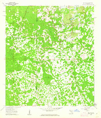
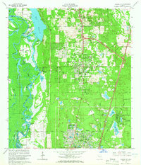
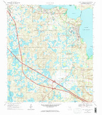
(23)- 1960 Map of Sorrento, 1962 Print
 1960 Sorrento1962 Print · USGSLake and Orange Counties are captured here in the early 1960s, showing a landscape defined by citrus groves and spring-fed waters. Genealogists can locate family landmarks like Tangerine Cem and Lake Ola Chapel near the Atlantic Coast Line railroad.4 unique versions available
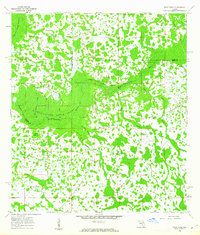
 - 1960 Map of Bay Lake, 1962 Print
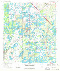
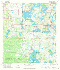
 1960 Bay Lake1962 Print · USGSFlorida's interior wetlands and timberlands are captured here in the early sixties, centered on the Sumter and Lake County border. Genealogists and historians can trace local landmarks like Bay Lake Ch or follow the path of the Seaboard Air Line through the cypress hammocks.3 unique versions available
 - 1960 Map of Rock Ridge, 1962 Print
 1960 Rock Ridge1962 Print · USGSThe Florida swamp country at the edge of Polk and Sumter Counties comes into focus during the early sixties. Genealogists and historians can trace the foundations of the Rock Ridge community, including Little Flock Ch and numerous segments of an Old Railroad Grade.4 unique versions available
 - 1962 Map of Orlando
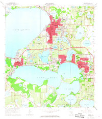
 1962 Orlando1962 Print · USGSCentral Florida was transformed by aerospace and citrus at the start of the sixties. Genealogists and historians can trace old community footprints from Eau Gallie to Leesburg, alongside landmarks like McCoy AFB and the winding Econlockhatchee River.
 - 1962 Map of Pine Lakes, 1963 Print
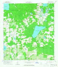
 1962 Pine Lakes1963 Print · USGSThe rural landscape near Cassia and the St. Johns River basin is captured here in the early sixties, showing a region defined by pine woods and citrus groves. Genealogists and local historians can trace the Old Railroad Grade and locate family sites near Cassia Cem or the remote Otter Mound.4 unique versions available
 - 1962 Map of Clermont East, 1964 Print
 1962 Clermont East1964 Print · USGSThe Florida ridge and its sprawling lake system are shown here in the early sixties, a landscape of citrus groves and rail-side towns. Genealogists and historians can trace the paths of the Seaboard Air Line through Ferndale or locate family sites near Williams Cem and Hickory Hammock Grove.4 unique versions available
 - 1962 Map of Lake Woodruff, 1964 Print
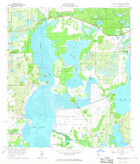
 1962 Lake Woodruff1964 Print · USGSThe Florida wetlands of the early sixties are captured here as the river-and-lake economy shifted toward modern residential growth. Trace old river landings like Bennetts Landing, the settlement at Saint Francis, and the winding path of the St Johns River.3 unique versions available
 - 1962 Map of Astatula, 1964 Print
 1962 Astatula1964 Print · USGSThe Lake County citrus country is captured here in the early sixties, showing the transition from agricultural groves to early residential pockets. Researchers can trace the Seaboard Air Line rail route and locate local landmarks like Sugarloaf Mountain and the Lake Apopka Lock and Dam.4 unique versions available
 - 1964 Map of Daytona Beach
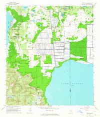
 1964 Daytona Beach1964 Print · USGSCoastal Florida in the mid-1960s shows a fascinating balance between burgeoning beach tourism and the deep interior wilderness of the Ocala National Forest. Researchers can trace the path of the Florida East Coast railway through historic settlements like St. Augustine, Marineland, and Palatka.
 - 1964 Map of Orange City, 1965 Print
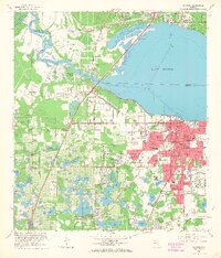
 1964 Orange City1965 Print · USGSOrange City and DeBary are shown during a period of significant inland growth in the mid-1960s, framed by the St Johns River and the Atlantic Coast Line. Genealogists can locate family landmarks like Hollywood Cemetery, Mt Berrah Ch, and the old Lansdowne Sch.5 unique versions available
 - 1965 Map of Leesburg East
 1965 Leesburg East1965 Print · USGSThe mid-sixties lakefront of central Florida comes alive here, showing the growth of Leesburg and its surrounding waterways. Researchers can trace historic local sites like Haines Creek Ch, Tavares Cem, and the old citrus lands near Tomato Hill.3 unique versions available
 - 1965 Map of Sanford SW, 1967 Print
 1965 Sanford SW1967 Print · USGSThe Lake and Seminole County borderlands are captured here in the mid-1960s, showing a transition from swampy wilderness to early lakeside settlement. Researchers can trace the Atlantic Coast Line through Cassia Station and locate the Ethel Cem near the vanished village of Ethel.4 unique versions available
 - 1965 Map of Umatilla, 1967 Print
 1965 Umatilla1967 Print · USGSLake County's watery landscape is revealed in the mid-sixties, where the citrus and rail economy of Umatilla meets the Ocala National Forest. Genealogists and local historians can trace family plots at Umatilla Cem or follow the Atlantic Coast Line tracks to Altoona.5 unique versions available
 - 1965 Map of Paisley, 1967 Print
 1965 Paisley1967 Print · USGSLake County's eastern wilderness is documented here in the mid-1960s, showing the intersection of the Ocala National Forest and local water systems. Researchers can locate the Ponceannah Cem, the remote Paisley Lookout Tower, and the early settlement layout at Paisley.4 unique versions available
 - 1965 Map of Sanford, 1968 Print
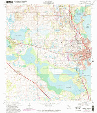
 1965 Sanford1968 Print · USGSSanford and the southern shores of Lake Monroe are captured here in the mid-1960s, a period of established rail infrastructure and military presence. Genealogists and local historians can locate early neighborhoods like Bookertown and Goldsboro Sch, or trace the extensive rail operations at Rand Yard.5 unique versions available
 - 1966 Map of Leesburg West
 1966 Leesburg West1966 Print · USGSMid-century Leesburg and Lake County are shown as the citrus groves and lakefronts began to welcome new residential growth. Genealogists and researchers can locate Lone Oak Cemetery, trace the Seaboard Coast Line, or find landmarks like Bugg Spring and Shiloh Ch.5 unique versions available
 - 1966 Map of Lady Lake, 1967 Print
 1966 Lady Lake1967 Print · USGSThe citrus-growing country between Lake and Marion counties comes into focus during the mid-sixties, centered on the growing community of Lady Lake. Researchers can trace local genealogy and land use through labels for Forest Hill Cem, Stanton Sch, and the Seaboard Coast Line railroad.4 unique versions available
 - 1966 Map of Eustis, 1968 Print
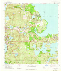
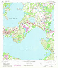
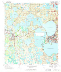
 1966 Eustis1968 Print · USGSLake County's waterfront communities thrive in the mid-sixties, dominated by a vast network of interconnected lakes and the citrus economy. Genealogists and local historians can trace family sites near Eustis and Mount Dora, or locate the Milner-Rosenwald Academy and Greenwood Cemetery.3 unique versions available
 - 1966 Map of Emeralda Island, 1968 Print
 1966 Emeralda Island1968 Print · USGSCentrally located between two major lakes in the mid-1960s, this area shows a landscape of Florida hammocks and river crossings. Genealogists and local historians can locate Starkes Ferry, the settlement of Lisbon, and landmarks like Bull Hammock near the Ocala National Forest.3 unique versions available
 - 1969 Map of Center Hill, 1971 Print
 1969 Center Hill1971 Print · USGSThe Sumter and Lake County line in the late sixties shows a landscape of expansive wetlands and developing infrastructure. Researchers can trace the path of the Seaboard Coast Line, locate Cool Spring Cem, and see the footprint of the University of Florida State Experimental Farm.
 - 1969 Map of Clermont West, 1971 Print
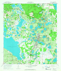
 1969 Clermont West1971 Print · USGSLake County at the end of the sixties is a world of interconnected waterways and growing citrus-belt towns. Genealogists and local historians can trace family-named sites like Dukes Cem and Greenwood Cem or explore the early layout of Groveland and Mascotte.2 unique versions available
 - 1969 Map of Howey In The Hills, 1971 Print
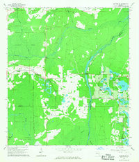
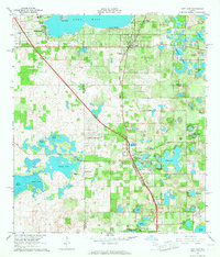
 1969 Howey In The Hills1971 Print · USGSLake County at the end of the 1960s showcases a transition between traditional agriculture and modern infrastructure. You can trace the local landscape through landmarks like Howey Academy, Taylor Memorial Cem, and the Seaboard Coast Line railroad.2 unique versions available
 - 1969 Map of Mascotte, 1971 Print
 1969 Mascotte1971 Print · USGSCentral Florida’s citrus and wetland corridor comes into focus in the late sixties, showing the rail-dependent growth of Mascotte and Groveland. Genealogists can trace rural life through landmarks like Midway Ch, Carters Island, and the Seaboard Coast Line.
End of results
Showing maps 1-23 of 23
Top cities of Lake County
- Four Corners historical maps
- Clermont historical maps
- Leesburg historical maps
- Eustis historical maps
- Tavares historical maps
- Groveland historical maps
See more
Frequently asked questions
- What are the different types of historical maps available for Lake County?
- What is the oldest map of Lake County?
- Where can I purchase historical maps of Lake County for my home or office?
- Where can I download high-res historical maps of Lake County?
- Are there historical topographic maps available for Lake County?
- Is there historical aerial imagery available for Lake County?
- Where are historical maps of Lake County sourced from?