1970s Maps of Alexander Springs, Florida
Explore 2 historic maps of Alexander Springs from the 1970s. These maps offer a rare glimpse into what life looked like during the 1970s — showing old roads, neighborhoods, homes, and landmarks that have changed or disappeared over time.
Whether you're researching your family's past, planning a metal detecting trip, or studying how Alexander Springs's landscape evolved across the 1970s, these high-resolution maps are a powerful tool for exploring the history of this region.
- Focus on a specific era: All maps on this page are from the 1970s, giving you a focused view of this time period.
- See what’s changed: Compare century-old streets, trails, and buildings to today's modern landscape using overlays and satellite layers.
- Research with precision: Use these maps for genealogy, historical research, land use analysis, or educational projects.
- View, download, or print: Maps are fully viewable online in high resolution, and can be downloaded or printed for your own records.
Start exploring Alexander Springs's history through authentic maps from the 1970s. This is your window into the past.
Alexander Springs, FL maps
(2)- 1972 Map of Alexander Springs, 1973 Print
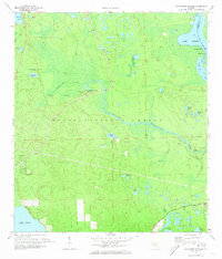 1972 Alexander Springs1973 Print · USGSIn the early seventies, the Lake County wilderness within the Ocala National Forest remained a landscape defined by water and woods. Genealogists and historians can locate Shackley Cem or trace the winding St Johns River past Bowers Bluff.
 - 1978 Map of Daytona Beach, 1980 Print
 1978 Daytona Beach1980 Print · USGSCoastal development meets the wild Florida interior in the late seventies, spanning from the Atlantic beaches to the St. Johns River. Trace the growth of Daytona Beach or find inland outposts like Salt Springs, De Leon Springs, and the U S Naval Reservation.2 unique versions available
End of results
Showing maps 1-2 of 2
Top cities near Alexander Springs
- Umatilla historical maps
- Bunnell historical maps
- Pierson historical maps
- Lisbon historical maps
- Altoona historical maps
Frequently asked questions
- What are the different types of historical maps available for Alexander Springs?
- What is the oldest map of Alexander Springs?
- Where can I purchase historical maps of Alexander Springs for my home or office?
- Where can I download high-res historical maps of Alexander Springs?
- Are there historical topographic maps available for Alexander Springs?
- Is there historical aerial imagery available for Alexander Springs?
- Where are historical maps of Alexander Springs sourced from?