1900s (20th Century) Maps of Calusa Ridge, Florida
Explore 8 historic maps of Calusa Ridge from the 1900s (20th Century). These maps offer a rare glimpse into what life looked like during the 1900s — showing old roads, neighborhoods, homes, and landmarks that have changed or disappeared over time.
Whether you're researching your family's past, planning a metal detecting trip, or studying how Calusa Ridge's landscape evolved across the 1900s, these high-resolution maps are a powerful tool for exploring the history of this region.
- Focus on a specific era: All maps on this page are from the 1900s, giving you a focused view of this time period.
- See what’s changed: Compare century-old streets, trails, and buildings to today's modern landscape using overlays and satellite layers.
- Research with precision: Use these maps for genealogy, historical research, land use analysis, or educational projects.
- View, download, or print: Maps are fully viewable online in high resolution, and can be downloaded or printed for your own records.
Start exploring Calusa Ridge's history through authentic maps from the 1900s. This is your window into the past.
Calusa Ridge, FL maps
(8)- 1956 Map of Tampa, 1964 Print
 1956 Tampa1964 Print · USGSThe Florida Gulf Coast thrived in the mid-fifties, from the bustling docks of Tampa to the quiet shores of Sanibel. Genealogists and historians can trace old rail lines like the Atlantic Coast Line or find early layouts of Port Charlotte and Bokeelia.2 unique versions available
 - 1956 Map of Charlotte Harbor, 1982 Print
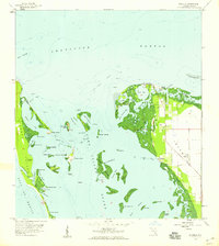
 1956 Charlotte Harbor1982 Print · USGSCoastal Florida in the mid-fifties reveals the early growth of bayside communities and the preservation of vast wetland refuges. Genealogists and historians can trace rail lines like the Seaboard Air Line and find historic waterfront locales from Boca Grande to Punta Gorda.
 - 1958 Map of Bokeelia, 1959 Print
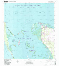
 1958 Bokeelia1959 Print · USGSThe northern tip of Pine Island and its surrounding barrier keys are captured here in the late fifties as a network of fishing villages and archaeological sites. Researchers can locate ancient landmarks like Howard Mound and trace the original footprints of Bokeelia and Pineland.5 unique versions available
 - 1959 Map of Tampa
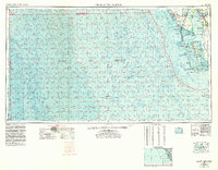
 1959 Tampa1959 Print · USGSThe Florida Gulf Coast appears in this late fifties survey during a period of steady coastal growth and established rail commerce. Researchers can trace historic neighborhoods and transit lines from Tampa to St Petersburg, or locate landmarks like Mac Dill AFB and Boca Grande.
 - 1960 Map of Tampa
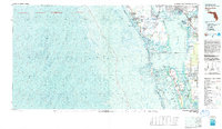
 1960 Tampa1960 Print · USGSThe Florida Gulf Coast was undergoing a major transformation at the start of the sixties, with new bridges linking burgeoning cities across the bays. Researchers can trace the mid-century footprints of St Petersburg and Tampa, or locate coastal landmarks like Mac Dill AFB and the Sunshine Skyway.2 unique versions available
 - 1972 Map of Tampa, 1974 Print
 1972 Tampa1974 Print · USGSThe Florida Gulf Coast appears in a period of significant growth during the early seventies, from the urban centers of the bay to the quiet southern keys. Researchers can trace the expansion of St Petersburg or locate family sites near Safety Harbor, Valrico, and Boca Ciega.
 - 1981 Map of Charlotte Harbor, 1983 Print
 1981 Charlotte Harbor1983 Print · USGSCoastal Florida is captured in a period of significant growth during the early eighties, balancing new residential developments with vast protected preserves. Trace the expansion of Port Charlotte and Cape Coral alongside the Seaboard Coast Line and Cayo Costa State Preserve.
 - 1994 Map of Bokeelia, 1998 Print
 1994 Bokeelia1998 Print · USGSPine Island and the northern Lee County coast are shown here in the mid-nineties, capturing a landscape of barrier islands and protected sounds. Genealogists and historians can locate early settlements at Bokeelia and Pineland, or trace ancient sites such as Howard Mound and Faulkner Mound.
End of results
Showing maps 1-8 of 8
Top cities near Calusa Ridge
- Cape Coral historical maps
- Fort Myers historical maps
- Punta Gorda historical maps
- Fort Myers Beach historical maps
- Sanibel historical maps
Frequently asked questions
- What are the different types of historical maps available for Calusa Ridge?
- What is the oldest map of Calusa Ridge?
- Where can I purchase historical maps of Calusa Ridge for my home or office?
- Where can I download high-res historical maps of Calusa Ridge?
- Are there historical topographic maps available for Calusa Ridge?
- Is there historical aerial imagery available for Calusa Ridge?
- Where are historical maps of Calusa Ridge sourced from?