1990s Maps of Leon County, Florida
Explore 10 historic maps of Leon County from the 1990s. These maps offer a rare glimpse into what life looked like during the 1990s — showing old roads, neighborhoods, homes, and landmarks that have changed or disappeared over time.
Whether you're researching your family's past, planning a metal detecting trip, or studying how Leon County's landscape evolved across the 1990s, these high-resolution maps are a powerful tool for exploring the history of this region.
- Focus on a specific era: All maps on this page are from the 1990s, giving you a focused view of this time period.
- See what’s changed: Compare century-old streets, trails, and buildings to today's modern landscape using overlays and satellite layers.
- Research with precision: Use these maps for genealogy, historical research, land use analysis, or educational projects.
- View, download, or print: Maps are fully viewable online in high resolution, and can be downloaded or printed for your own records.
Start exploring Leon County's history through authentic maps from the 1990s. This is your window into the past.
Leon County, FL maps
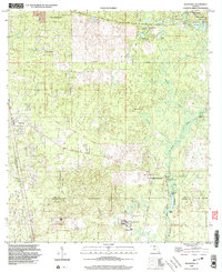
(10)- 1994 Map of Miccosukee, 1998 Print
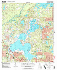
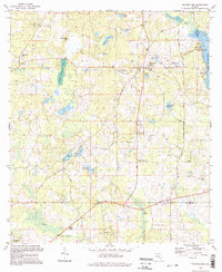 1994 Miccosukee1998 Print · USGSUpper Leon County is shown here in the 1990s, maintaining its character of small settlements and rail-side communities. Researchers can trace family roots at Centenary Ch Cem and Indian Springs Ch or locate landmarks like the Lookout Tower and Wadesboro.
 - 1994 Map of Havana South, 1998 Print
 1994 Havana South1998 Print · USGSGadsden County in the 1990s was a landscape where tobacco-growing history met the wild wetlands of the Ochlockonee. Local historians can trace old homesteads near Scotland and Gibson, or locate family sites like Nicholson-Freeman Cem and St James Ch.
 - 1994 Map of Miccosukee NE, 1998 Print
 1994 Miccosukee NE1998 Print · USGSThe Georgia-Florida borderlands come into focus in the 1990s, revealing a landscape of scattered rural congregations and quiet ponds. Researchers can trace the Watson Line survey boundary and locate landmarks like Sunny Hill, Spring Hill Cem, and the Old Railroad Grade.
 - 1994 Map of Beachton, 1998 Print
 1994 Beachton1998 Print · USGSThe Georgia-Florida border comes alive in this late twentieth-century study of the wetlands and rural settlements north of Tallahassee. Researchers can trace family history through several burial sites and churches, including Evergreen Cem, Beth Page Ch, and the small community of Beachton.
 - 1999 Map of Tallahassee, 2000 Print
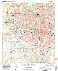 1999 Tallahassee2000 Print · USGSTallahassee at the close of the century shows a bustling state capital and academic hub surrounded by the southern pines. Researchers can trace historic sites like the Old City Cemetery, schools including Leon High Sch, and the grounds of Florida State University.
 - 1999 Map of Woodville, 2003 Print
 1999 Woodville2003 Print · USGSThe Leon County pine woods and springs are documented here at the close of the twentieth century. Researchers can trace the Forbes Purchase Line and locate local landmarks like Rhodes Cem and the Natural Bridge Battlefield State Historic Site.
 - 1999 Map of Lafayette, 2003 Print
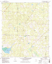
 1999 Lafayette2003 Print · USGSTallahassee and its eastern suburbs are shown at the turn of the millennium as urban growth meets the sprawling wetlands of Lake Lafayette. Genealogists and local historians can trace the grounds of St Peter Cemetery, Lincoln High Sch, and the Federal Correctional Institution.
 - 1999 Map of Lake Munson, 2003 Print
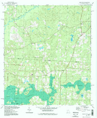
 1999 Lake Munson2003 Print · USGSThe southern edge of the state capital meets the dense pines of the national forest in the late twentieth century. Researchers can trace historic property boundaries along the Forbes Purchase Line and locate rural landmarks like St Peters Ch or the community of Woodville.
 - 1999 Map of Lake Jackson, 2003 Print
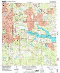
 1999 Lake Jackson2003 Print · USGSTallahassee's northward expansion into Leon County is caught here at a moment of transition in the late nineties. Genealogists and researchers can trace local family landmarks and institutional roots at Memory Gardens Cem, El Destinado, and St Pauls Ch.
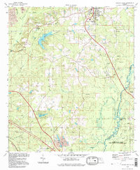
 - 1999 Map of Bradfordville, 2004 Print
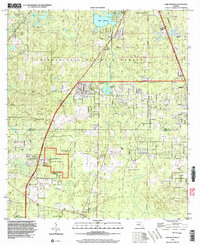
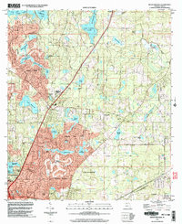 1999 Bradfordville2004 Print · USGSThe northern Tallahassee suburbs take shape in the late nineties as residential development meets historic Florida plantations. Genealogists and local historians can trace legacy sites like the Bradford-Eppes Cem, Pisgah Ch, and the original settlement at Bradfordville.
End of results
Showing maps 1-10 of 10
Top cities of Leon County
Frequently asked questions
- What are the different types of historical maps available for Leon County?
- What is the oldest map of Leon County?
- Where can I purchase historical maps of Leon County for my home or office?
- Where can I download high-res historical maps of Leon County?
- Are there historical topographic maps available for Leon County?
- Is there historical aerial imagery available for Leon County?
- Where are historical maps of Leon County sourced from?