Old Maps of Leon County, Florida
Explore 156 old maps of Leon County, spanning from 1940 to today. These high-resolution historic maps reveal how streets, neighborhoods, landmarks, and natural features evolved over time — perfect for genealogy, metal detecting, research, and local history exploration.
What you can do with these maps:
- See how Leon County changed over time: Compare historical maps to modern-day views to trace roads, homesites, rail lines & more.
- View detailed metadata: Each map includes creators, publishers, year, scale, and archive source.
- Overlay maps with satellite & LiDAR: Visualize the past alongside modern tools to explore terrain & human change.
- Trusted historical sources: Maps sourced from the USGS, Library of Congress, and other archives.
- Access maps your way: View online, download high-res files, or order prints for personal or research use.
Start exploring old maps of Leon County to uncover forgotten places, hidden landmarks, and the deep history beneath your feet.
Leon County, FL maps
(156)- 1940 Map of Tallahassee, 1958 Print
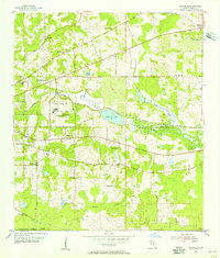
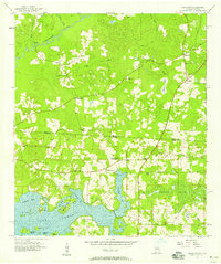
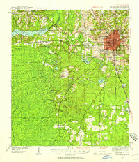 1940 Tallahassee1958 Print · USGSFlorida's capital city and the surrounding Leon County pine forests are captured here just before the mid-century expansion. Genealogists and local historians can trace rural communities like Hilliardville and Woodville alongside landmarks like Richardson Sch and Lake Talquin.2 unique versions available
 - 1942 Map of Tallahassee
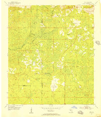
 1942 Tallahassee1942 Print · USGSTallahassee and the surrounding Leon County area appear here in the early 1940s, balancing its role as a college town with the wilderness of the Apalachicola National Forest. Researchers can trace the rural church and school networks of Woodville and Spring Hill, or locate early campus footprints for Florida State College for Women.
 - 1943 Map of Tallahassee
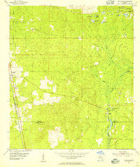
 1943 Tallahassee1943 Print · USGSMid-century Tallahassee and the eastern edge of the Apalachicola National Forest appear here in the years just before post-war suburban growth. Genealogists can trace rural communities through landmarks like Florida Agricultural and Mechanical College, Hilliardville, and the Gum Pond Sch.2 unique versions available
 - 1943 Map of Lake Talquin
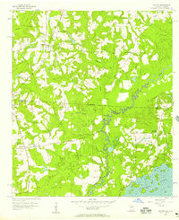
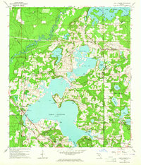
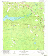
 1943 Lake Talquin1943 Print · USGSFlorida's northern forest and river country are mapped here in the early 1940s as the Apalachicola National Forest meets the shores of Lake Talquin. Genealogists can locate family landmarks like Bradwell Sch, Antioch Ch, and numerous private landings along the Ochlockonee River.2 unique versions available
 - 1954 Map of Lloyd, 1955 Print
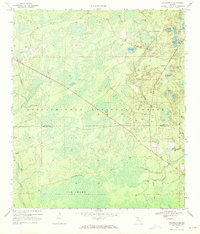
 1954 Lloyd1955 Print · USGSIn the mid-1950s, the rural borderlands of Leon and Jefferson counties were a landscape of karst sinks and small rail-side hamlets. Genealogists and historians can trace the foundations of local life through landmarks like St Lukes Ch, Jones Cem, and the historic Seaboard Air Line tracks.2 unique versions available
 - 1954 Map of Lafayette, 1955 Print
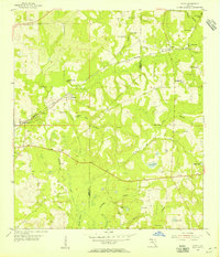
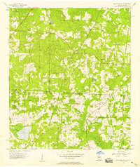
 1954 Lafayette1955 Print · USGSLeon County at mid-century shows a landscape of institutional growth and established rural hamlets east of the capital. Researchers can trace the lineage of local congregations at Shady Grove Ch and New Zion Ch or locate the Ward Sch and Southfield Cem.3 unique versions available
 - 1954 Map of Cody, 1956 Print
 1954 Cody1956 Print · USGSIn the mid-1950s, the boundary between Jefferson, Leon, and Wakulla counties remained a landscape of limestone sinks and rural hamlets. Researchers can trace the early road networks and hydrological landmarks like Hardy Sink, Cody, and Tooles Hammock.2 unique versions available
 - 1954 Map of Woodville, 1956 Print
 1954 Woodville1956 Print · USGSThe Leon and Wakulla county line area in the mid-1950s reveals a landscape defined by the karst hydrology of the St Marks River. Local historians can trace the paths of the Seaboard Air Line railroad and locate old family burial grounds like Rhodes Cem and Godwin Cem.2 unique versions available
 - 1954 Map of Valdosta, 1967 Print
 1954 Valdosta1967 Print · USGSThe South Georgia and North Florida borderlands are captured here in the mid-fifties, showing the deep timber and wetland networks of the coastal plain. Researchers can trace the path of the Atlantic Coast Line through Valdosta or explore the interior of the Okefenokee Swamp.2 unique versions available
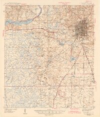
 - 1954 Map of Tallahassee, 1967 Print
 1954 Tallahassee1967 Print · USGSThe Florida Panhandle and South Georgia are captured here during a period of mid-century growth and military expansion. Researchers can trace the development of Panama City, the footprint of Tyndall Air Force Base, and the rail lines of the Atlantic Coast Line.4 unique versions available
 - 1956 Map of Calvary, 1957 Print
 1956 Calvary1957 Print · USGSThe Georgia-Florida borderlands come into focus in the mid-1950s, showing a rural landscape defined by the Ochlockonee River. Genealogists and historians can trace community roots through numerous landmarks like St Johns Ch, Pedemont Cem, and the Bell Sch (Abandoned).
 - 1957 Map of Beachton, 1958 Print
 1957 Beachton1958 Print · USGSThe Georgia-Florida borderlands come to life in the late 1950s, showing a landscape of sprawling plantations and quiet rural crossroads. Researchers can trace family history at Evergreen Cem and Van Brunt Cem or locate the Strickland Sch (Abandoned) near the banks of Lake Iamonia.2 unique versions available
 - 1957 Map of Miccosukee NE, 1958 Print
 1957 Miccosukee NE1958 Print · USGSThe Georgia-Florida borderlands come to life in the late fifties, showing a rural landscape defined by family cemeteries and country churches. Genealogists can trace roots at Copeland Cem or locate historic meeting places like Trinity Ch and New Hope Ch.2 unique versions available
 - 1958 Map of Valdosta
 1958 Valdosta1958 Print · USGSSouth Georgia and North Florida are captured here in the mid-fifties, showing the vast Okefenokee Swamp and the vital timber and rail corridors connecting the two states. Researchers can locate the footprint of Moody Air Force Base, trace the Live Oak Perry and Gulf railroad, or find early community sites like Bakers Mill and Paradise Church.
 - 1959 Map of Tallahassee
 1959 Tallahassee1959 Print · USGSFlorida's Panhandle and the Big Bend region appear here in the mid-fifties, showing a landscape defined by its great river systems and developing coast. Trace the early layout of Panama City, the expansive Apalachicola National Forest, and the coastal St Marks Lighthouse.
 - 1959 Map of Valdosta
 1959 Valdosta1959 Print · USGSThe Georgia-Florida borderlands in the mid-fifties reveal a landscape of massive blackwater swamps and emerging military aviation hubs. Genealogists and historians can trace rail-stop towns like Fargo and Stockton or explore the interior reaches of the Okefenokee Swamp and Billys Island.
 - 1960 Map of Tallahassee
 1960 Tallahassee1960 Print · USGSThe Florida Panhandle and southern Georgia are captured here in the mid-twentieth century, showing a region defined by its rivers and military installations. Genealogists and historians can trace the growth of Tallahassee or locate coastal landmarks like the St Marks Lighthouse and Tyndall Air Force Base.
 - 1963 Map of Bradfordville, 1964 Print
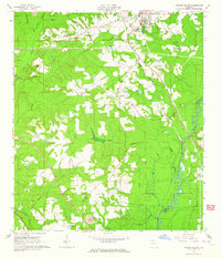
 1963 Bradfordville1964 Print · USGSNorth of Tallahassee in the early sixties, this area shows a landscape of traditional communities and numerous named ponds. Genealogists and historians can locate family landmarks like the Bradford-Eppes Cem and long-standing congregations at Pisgah Ch or St Philips Ch.
 - 1963 Map of Lake Miccosukee, 1964 Print
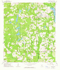
 1963 Lake Miccosukee1964 Print · USGSJefferson County in the early 1960s reveals a landscape of lakeside settlements and evolving rail corridors. Genealogists and local historians can trace family-named sites like Casa Blanco, Montivilla, and rural congregations at Macedonia Ch or Juniors Hill Ch.2 unique versions available
 - 1963 Map of Lake Jackson, 1964 Print
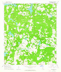
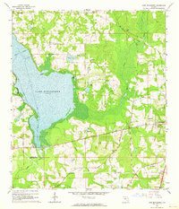
 1963 Lake Jackson1964 Print · USGSNorth of Tallahassee in the early sixties, this area shows the initial wave of suburban growth around Lake Jackson. Genealogists and local historians can trace early subdivisions like Harbinwood Estates and rural landmarks such as St Marks Ch and the Seaboard Air Line railroad.
 - 1963 Map of Havana South, 1964 Print
 1963 Havana South1964 Print · USGSGadsden County at the start of the 1960s shows a landscape defined by the Seaboard Air Line and the winding Ochlockonee River. Genealogists and local historians can trace rural communities through landmarks like China Hill Ch, Pine Park Sch, and the Nicholson-Freeman Cem.
 - 1963 Map of Miccosukee, 1964 Print
 1963 Miccosukee1964 Print · USGSThe Leon and Jefferson county borderlands are shown here in the early sixties, centered on the historic community of Miccosukee. Researchers can trace rural life through landmarks like Wadesboro, the Concord School, and local cemeteries like Centenary Cemetery.
 - 1968 Map of Ward, 1977 Print
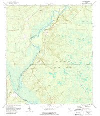 1968 Ward1977 Print · USGSThe Florida Panhandle's river country is documented here in the late sixties, where the Ochlockonee River meets the Apalachicola National Forest. Researchers can trace old family sites and burial grounds like Blue Creek Ch Cem or locate the riverside Stoutamire Landing.
 - 1969 Map of Midway, 1972 Print
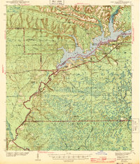
 1969 Midway1972 Print · USGSThe Ochlockonee River valley and Lake Talquin come into focus during the late sixties, showing the quiet transition between the Apalachicola National Forest and rural settlements. Genealogists can locate family landmarks like Mt Moriah Ch, Norfleet, and several cemeteries scattered across the Gadsden county line.2 unique versions available
 - 1969 Map of Hilliardville, 1972 Print
 1969 Hilliardville1972 Print · USGSLeon and Wakulla counties are captured in the late sixties as the timber and water of the Apalachicola National Forest define the local economy. Genealogists and historians can trace an Old Railroad Grade, locate the New Light Ch, and explore the settlement at Hilliardville.2 unique versions available
Showing maps 1-25 of 156
Top cities of Leon County
Frequently asked questions
- What are the different types of historical maps available for Leon County?
- What is the oldest map of Leon County?
- Where can I purchase historical maps of Leon County for my home or office?
- Where can I download high-res historical maps of Leon County?
- Are there historical topographic maps available for Leon County?
- Is there historical aerial imagery available for Leon County?
- Where are historical maps of Leon County sourced from?