1990s Maps of Big Scrub, Florida
Explore 1 historic maps of Big Scrub from the 1990s. These maps offer a rare glimpse into what life looked like during the 1990s — showing old roads, neighborhoods, homes, and landmarks that have changed or disappeared over time.
Whether you're researching your family's past, planning a metal detecting trip, or studying how Big Scrub's landscape evolved across the 1990s, these high-resolution maps are a powerful tool for exploring the history of this region.
- Focus on a specific era: All maps on this page are from the 1990s, giving you a focused view of this time period.
- See what’s changed: Compare century-old streets, trails, and buildings to today's modern landscape using overlays and satellite layers.
- Research with precision: Use these maps for genealogy, historical research, land use analysis, or educational projects.
- View, download, or print: Maps are fully viewable online in high resolution, and can be downloaded or printed for your own records.
Start exploring Big Scrub's history through authentic maps from the 1990s. This is your window into the past.
Big Scrub, FL maps
(1)- 1994 Map of Lake Mary, 1998 Print
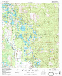 1994 Lake Mary1998 Print · USGSMarion County's deep woods and prairie wetlands are preserved here in the late twentieth century. Researchers can locate the Moss Bluff Ch and trace the shores of Lake Mary, Doe Lake, and Lake Catherine within the sprawling Ocala National Forest.
End of results
Showing maps 1-1 of 1
Top cities near Big Scrub
- The Villages historical maps
- Leesburg historical maps
- Eustis historical maps
- Tavares historical maps
- Mount Dora historical maps
- Lady Lake historical maps
See more
Frequently asked questions
- What are the different types of historical maps available for Big Scrub?
- What is the oldest map of Big Scrub?
- Where can I purchase historical maps of Big Scrub for my home or office?
- Where can I download high-res historical maps of Big Scrub?
- Are there historical topographic maps available for Big Scrub?
- Is there historical aerial imagery available for Big Scrub?
- Where are historical maps of Big Scrub sourced from?