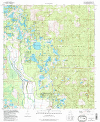
1994 Map of Lake Mary
USGS Topo · Published 1998About this map
The Ocala National Forest and the Ocala State Wildlife Management Area dominate this landscape, preserving a complex network of wetlands and prairie clearings. Small settlements and community landmarks like Moss Bluff and the nearby Moss Bluff Ch are situated near the western edge of the forest boundary. The hydrology of the area is particularly intricate, featuring a dense cluster of ponds and lakes including Lake Mary, Doe Lake, and Lake Catherine. The map reveals the characteristic "prairie" system of this region—shallow, open wetlands such as Nancy Prairie and Big Prairie—which historically fluctuated between wet and dry cycles. Unusual local landmarks like Forts Bear Hole and Volusia Bear Hole suggest distinct geological depressions or local wildlife corridors within the timbered tracts of the national forest.
Find a feature on this map
56 named features on this map. Tap any name to fly to it.
Don’t see what you’re looking for? This feature index may not catch every label — zoom into the map to look around manually.
Map Details
Editions of this 1994 Lake Mary Map
This is the sole edition of this map. No revisions or reprints were ever made.
Other maps of this area

1954 · Daytona Beach
USGS Topo · 1:250,000

1955 · Orlando
USGS Topo · 1:250,000

1957 · Orlando
USGS Topo · 1:250,000

1958 · Orlando
USGS Topo · 1:250,000

1958 · Daytona Beach
USGS Topo · 1:250,000

1962 · Orlando
USGS Topo · 1:250,000

1964 · Daytona Beach
USGS Topo · 1:250,000

1965 · Umatilla
USGS Topo · 1:24,000
1966 · Lady Lake
USGS Topo · 1:24,000
1966 · Emeralda Island
USGS Topo · 1:24,000