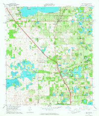
1966 Map of Lady Lake
USGS Topo · Published 1967About this map
Lake Weir dominates the northern landscape of this mid-1960s survey, anchoring a region defined by a high density of small lakes and citrus-belt settlements. The community of Weirsdale sits along the Seaboard Coast Line railroad, which serves as a central corridor for transport and commerce through the heart of the area. Moving south toward the town of Lady Lake, the map reveals a transition into more concentrated residential areas like Orange Blossom Hills South and Carlton Village. Numerous community focal points are documented, including several country churches such as St Johns Ch and New Salem Ch, alongside family-named burial grounds like Simpson Cem and Greenwood Cem. The varied terrain is marked by dozens of named water bodies, from Cherry Lake and Lake Miona in the southwest to the clustered waters surrounding the town center, including Lake Alice and Lake Hattie.
Find a feature on this map
53 named features on this map. Tap any name to fly to it.
Don’t see what you’re looking for? This feature index may not catch every label — zoom into the map to look around manually.
Map Details
Editions of this 1966 Lady Lake Map
4 editions found
Other maps of this area

1893 · Panasoffkee
USGS Topo · 1:62,500

1895 · Panasoffkee
USGS Topo · 1:62,500

1895 · Ocala
USGS Topo · 1:62,500

1954 · Gainesville
USGS Topo · 1:250,000

1954 · Daytona Beach
USGS Topo · 1:250,000

1955 · Plant City
USGS Topo · 1:250,000

1955 · Orlando
USGS Topo · 1:250,000

1957 · Orlando
USGS Topo · 1:250,000

1958 · Orlando
USGS Topo · 1:250,000

1958 · Daytona Beach
USGS Topo · 1:250,000