1940s Maps of East Ridge Retirement Village, Florida
Explore 1 historic maps of East Ridge Retirement Village from the 1940s. These maps offer a rare glimpse into what life looked like during the 1940s — showing old roads, neighborhoods, homes, and landmarks that have changed or disappeared over time.
Whether you're researching your family's past, planning a metal detecting trip, or studying how East Ridge Retirement Village's landscape evolved across the 1940s, these high-resolution maps are a powerful tool for exploring the history of this region.
- Focus on a specific era: All maps on this page are from the 1940s, giving you a focused view of this time period.
- See what’s changed: Compare century-old streets, trails, and buildings to today's modern landscape using overlays and satellite layers.
- Research with precision: Use these maps for genealogy, historical research, land use analysis, or educational projects.
- View, download, or print: Maps are fully viewable online in high resolution, and can be downloaded or printed for your own records.
Start exploring East Ridge Retirement Village's history through authentic maps from the 1940s. This is your window into the past.
East Ridge Retirement Village, FL maps
(1)- 1949 Map of Perrine
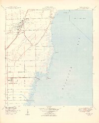 1949 Perrine1949 Print · USGSCoastal Miami-Dade County comes alive in the late 1940s as the railway and early road networks began to shape the south Florida suburbs. Genealogists and historians can trace the growth of Perrine, the rural roads like Eureka Drive, and the path of the Florida East Coast railroad.2 unique versions available
End of results
Showing maps 1-1 of 1
Top cities near East Ridge Retirement Village
- Miami historical maps
- Kendall historical maps
- Miami Beach historical maps
- Homestead historical maps
- Coral Gables historical maps
- Cutler Bay historical maps
See more
Frequently asked questions
- What are the different types of historical maps available for East Ridge Retirement Village?
- What is the oldest map of East Ridge Retirement Village?
- Where can I purchase historical maps of East Ridge Retirement Village for my home or office?
- Where can I download high-res historical maps of East Ridge Retirement Village?
- Are there historical topographic maps available for East Ridge Retirement Village?
- Is there historical aerial imagery available for East Ridge Retirement Village?
- Where are historical maps of East Ridge Retirement Village sourced from?