1940s Maps of South Bay Estates, Miami
Explore 2 historic maps of South Bay Estates from the 1940s. These maps offer a rare glimpse into what life looked like during the 1940s — showing old roads, neighborhoods, homes, and landmarks that have changed or disappeared over time.
Whether you're researching your family's past, planning a metal detecting trip, or studying how South Bay Estates's landscape evolved across the 1940s, these high-resolution maps are a powerful tool for exploring the history of this region.
- Focus on a specific era: All maps on this page are from the 1940s, giving you a focused view of this time period.
- See what’s changed: Compare century-old streets, trails, and buildings to today's modern landscape using overlays and satellite layers.
- Research with precision: Use these maps for genealogy, historical research, land use analysis, or educational projects.
- View, download, or print: Maps are fully viewable online in high resolution, and can be downloaded or printed for your own records.
Start exploring South Bay Estates's history through authentic maps from the 1940s. This is your window into the past.
South Bay Estates, Miami maps
(2)- 1947 Map of Key Biscayne, 1961 Print
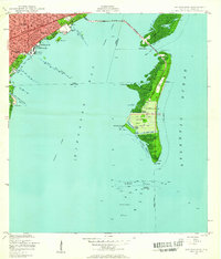 1947 Key Biscayne1961 Print · USGSKey Biscayne and the Miami waterfront are shown here just after the war, as the new causeway began to transform the islands. Researchers can trace early infrastructure like the US Coast Guard Air Station, Crandon Park, and the grounds of the Fla Adirondack Prep Sch.
 - 1949 Map of Key Biscayne
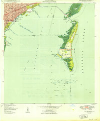 1949 Key Biscayne1949 Print · USGSBiscayne Bay and its barrier islands are captured here in the late 1940s, just as the Rickenbacker Causeway opened new access to the keys. Researchers can trace early infrastructure like Airline Road and landmarks like the Fla Adirondack Prep Sch or Cape Florida.2 unique versions available
End of results
Showing maps 1-2 of 2
Top cities near South Bay Estates
- Miami historical maps
- Hialeah historical maps
- Kendall historical maps
- Miami Gardens historical maps
- Miami Beach historical maps
- North Miami historical maps
See more
Frequently asked questions
- What are the different types of historical maps available for South Bay Estates?
- What is the oldest map of South Bay Estates?
- Where can I purchase historical maps of South Bay Estates for my home or office?
- Where can I download high-res historical maps of South Bay Estates?
- Are there historical topographic maps available for South Bay Estates?
- Is there historical aerial imagery available for South Bay Estates?
- Where are historical maps of South Bay Estates sourced from?