1900s (20th Century) Maps of Key West, Florida
Explore 9 historic maps of Key West from the 1900s (20th Century). These maps offer a rare glimpse into what life looked like during the 1900s — showing old roads, neighborhoods, homes, and landmarks that have changed or disappeared over time.
Whether you're researching your family's past, planning a metal detecting trip, or studying how Key West's landscape evolved across the 1900s, these high-resolution maps are a powerful tool for exploring the history of this region.
- Focus on a specific era: All maps on this page are from the 1900s, giving you a focused view of this time period.
- See what’s changed: Compare century-old streets, trails, and buildings to today's modern landscape using overlays and satellite layers.
- Research with precision: Use these maps for genealogy, historical research, land use analysis, or educational projects.
- View, download, or print: Maps are fully viewable online in high resolution, and can be downloaded or printed for your own records.
Start exploring Key West's history through authentic maps from the 1900s. This is your window into the past.
Key West, FL maps
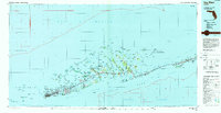
(9)- 1921 Map of Sugar Loaf Key
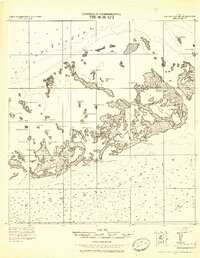 1921 Sugar Loaf Key1921 Print · USGSThe Lower Florida Keys are captured here in the early twentieth century before modern development transformed the island chain. Maritime researchers and genealogists can trace the original shorelines of Sugarloaf Key, Cudjoe Key, and family-named landmarks like Mallorys Key.2 unique versions available
 - 1921 Map of Key West
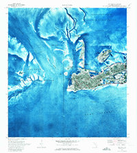
 1921 Key West1921 Print · USGSKey West at the end of the Florida East Coast Railway era is meticulously detailed in this early twentieth-century tactical survey. You can trace the island's coastal defenses at the E. Martello Tower and locate maritime landmarks like the N.W. Bar Light.
 - 1943 Map of Boca Chica
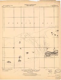
 1943 Boca Chica1943 Print · USGSThe Lower Keys are captured here during the Second World War as modern infrastructure begins to reshape the archipelago. Researchers can trace the development of Boca Chica Airport and early roads connecting Stock Island, Big Coppitt Key, and the Sugar Loaf Club.
 - 1943 Map of Key West
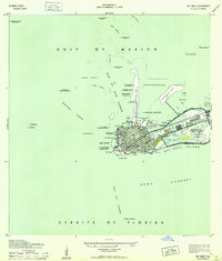 1943 Key West1943 Print · USGSKey West was a fortified maritime center during the war years, serving as a vital strategic link between the Gulf and the Atlantic. Researchers can locate military landmarks like Fort Taylor and Meacham Field, alongside old harbor features such as Key West Bight and Trumbo Island.3 unique versions available
 - 1962 Map of Key West
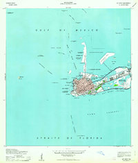 1962 Key West1962 Print · USGSKey West at the start of the sixties reveals a unique landscape where military readiness and island life converged. Genealogists and historians can trace the evolution of Key West Island through landmarks like Fort Taylor, Meacham Field, and Stock I.
 - 1971 Map of Key West, 1973 Print
 1971 Key West1973 Print · USGSKey West at the beginning of the 1970s reveals a bustling island city integrated with massive naval and aviation facilities. Genealogists and historians can trace the urban grid near City Cemetery, the shoreline at Smathers Beach, and military sites like Fort Taylor.2 unique versions available
 - 1971 Map of Boca Chica Key, 1973 Print
 1971 Boca Chica Key1973 Print · USGSThe Lower Florida Keys are shown during a period of significant military and institutional growth in the early seventies. Genealogists and historians can trace the footprint of the U.S. Naval Air Station Key West and community sites like Florida Keys Community College.
 - 1983 Map of Key West, 1984 Print
 1983 Key West1984 Print · USGSThe Lower Florida Keys are shown in detail in the early 1980s, centered on the military and civilian infrastructure of the archipelago. Trace the path of the Overseas Highway across the Sevenmile Bridge and locate historic sites like Bahia Honda State Park.2 unique versions available
 - 1989 Map of Key West, 1990 Print
 1989 Key West1990 Print · USGSThe Florida Keys at the end of the eighties reveal a complex maritime network of coral islands, military outposts, and protected wilderness. Researchers can trace the Overseas Highway across the Sevenmile Bridge and locate features like the U S Naval Air Station Key West and the National Key Deer Refuge.
End of results
Showing maps 1-9 of 9
Top neighborhoods of Key West
- New Town historical maps
- Midtown historical maps
- Old Town historical maps
- Truman Annex1 historical maps
- Bahama Village historical maps
- Casa Marina historical maps
See more
Frequently asked questions
- What are the different types of historical maps available for Key West?
- What is the oldest map of Key West?
- Where can I purchase historical maps of Key West for my home or office?
- Where can I download high-res historical maps of Key West?
- Are there historical topographic maps available for Key West?
- Is there historical aerial imagery available for Key West?
- Where are historical maps of Key West sourced from?