1970s Maps of Marathon Shores, Marathon
Explore 2 historic maps of Marathon Shores from the 1970s. These maps offer a rare glimpse into what life looked like during the 1970s — showing old roads, neighborhoods, homes, and landmarks that have changed or disappeared over time.
Whether you're researching your family's past, planning a metal detecting trip, or studying how Marathon Shores's landscape evolved across the 1970s, these high-resolution maps are a powerful tool for exploring the history of this region.
- Focus on a specific era: All maps on this page are from the 1970s, giving you a focused view of this time period.
- See what’s changed: Compare century-old streets, trails, and buildings to today's modern landscape using overlays and satellite layers.
- Research with precision: Use these maps for genealogy, historical research, land use analysis, or educational projects.
- View, download, or print: Maps are fully viewable online in high resolution, and can be downloaded or printed for your own records.
Start exploring Marathon Shores's history through authentic maps from the 1970s. This is your window into the past.
Marathon Shores, Marathon maps
(2)- 1971 Map of Marathon, 1973 Print
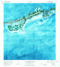 1971 Marathon1973 Print · USGSMarathon and the Middle Keys are shown in the early seventies as this island community entered a period of significant growth. Trace the development of Key Colony Beach, locate the Coast Guard Sta, or study the grounds of the Sombrero Country Club.
 - 1972 Map of Marathon
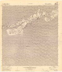 1972 Marathon1972 Print · USGSThe Middle Keys undergo significant development during the early seventies as new canal-front communities expand across Vaca Key. Researchers can trace the growth of Marathon and Key Colony Beach or locate landmarks like the Coast Guard Sta and High Sch.
End of results
Showing maps 1-2 of 2
Top cities near Marathon Shores
Frequently asked questions
- What are the different types of historical maps available for Marathon Shores?
- What is the oldest map of Marathon Shores?
- Where can I purchase historical maps of Marathon Shores for my home or office?
- Where can I download high-res historical maps of Marathon Shores?
- Are there historical topographic maps available for Marathon Shores?
- Is there historical aerial imagery available for Marathon Shores?
- Where are historical maps of Marathon Shores sourced from?