1910s Maps of Dyal, Florida
Explore 2 historic maps of Dyal from the 1910s. These maps offer a rare glimpse into what life looked like during the 1910s — showing old roads, neighborhoods, homes, and landmarks that have changed or disappeared over time.
Whether you're researching your family's past, planning a metal detecting trip, or studying how Dyal's landscape evolved across the 1910s, these high-resolution maps are a powerful tool for exploring the history of this region.
- Focus on a specific era: All maps on this page are from the 1910s, giving you a focused view of this time period.
- See what’s changed: Compare century-old streets, trails, and buildings to today's modern landscape using overlays and satellite layers.
- Research with precision: Use these maps for genealogy, historical research, land use analysis, or educational projects.
- View, download, or print: Maps are fully viewable online in high resolution, and can be downloaded or printed for your own records.
Start exploring Dyal's history through authentic maps from the 1910s. This is your window into the past.
Dyal, FL maps
(2)- 1917 Map of Hilliard, 1967 Print
 1917 Hilliard1967 Print · USGSNassau County at the start of the twentieth century was a landscape of timber camps and rail junctions. Genealogists can trace old homesteads near Hilliard and Callahan, or find vanished rural school sites like Romulus School and New Hope School.
 - 1919 Map of Hilliard
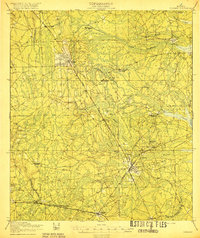 1919 Hilliard1919 Print · USGSNassau County's timber and rail economy is on full display in this post-WWI era survey of the Florida interior. Genealogists and historians can trace old homesteads and local institutions like New Hope School, Hodges Mill, and the rail junction at Callahan.3 unique versions available
End of results
Showing maps 1-2 of 2
Top cities near Dyal
- Jacksonville historical maps
- St. Marys historical maps
- Kingsland historical maps
- Folkston historical maps
- Hilliard historical maps
- Callahan historical maps
See more
Frequently asked questions
- What are the different types of historical maps available for Dyal?
- What is the oldest map of Dyal?
- Where can I purchase historical maps of Dyal for my home or office?
- Where can I download high-res historical maps of Dyal?
- Are there historical topographic maps available for Dyal?
- Is there historical aerial imagery available for Dyal?
- Where are historical maps of Dyal sourced from?