1940s Maps of Palm Beach Shores, Florida
Explore 2 historic maps of Palm Beach Shores from the 1940s. These maps offer a rare glimpse into what life looked like during the 1940s — showing old roads, neighborhoods, homes, and landmarks that have changed or disappeared over time.
Whether you're researching your family's past, planning a metal detecting trip, or studying how Palm Beach Shores's landscape evolved across the 1940s, these high-resolution maps are a powerful tool for exploring the history of this region.
- Focus on a specific era: All maps on this page are from the 1940s, giving you a focused view of this time period.
- See what’s changed: Compare century-old streets, trails, and buildings to today's modern landscape using overlays and satellite layers.
- Research with precision: Use these maps for genealogy, historical research, land use analysis, or educational projects.
- View, download, or print: Maps are fully viewable online in high resolution, and can be downloaded or printed for your own records.
Start exploring Palm Beach Shores's history through authentic maps from the 1940s. This is your window into the past.
Palm Beach Shores, FL maps
(2)- 1946 Map of Riviera Beach, 1956 Print
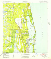 1946 Riviera Beach1956 Print · USGSPalm Beach County’s coastline in the mid-forties reveals a landscape defined by the Intracoastal Waterway and thriving rail corridors. Trace early development from Monet down to Riviera Beach, and locate coastal landmarks like the Seminole Golf Club and Peanut I.4 unique versions available
 - 1949 Map of Riviera Beach
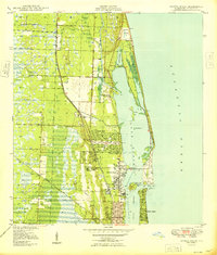 1949 Riviera Beach1949 Print · USGSThe Florida coast near Lake Park and Riviera Beach is shown here just after the war as the resort economy expanded. Trace the historic rail lines of the Florida East Coast, find the Seminole Golf Club, and locate the U S Coast Guard Reservation.
End of results
Showing maps 1-2 of 2
Top cities near Palm Beach Shores
- West Palm Beach historical maps
- Boynton Beach historical maps
- Wellington historical maps
- Palm Beach Gardens historical maps
- Jupiter historical maps
- Lake Worth Beach historical maps
See more
Frequently asked questions
- What are the different types of historical maps available for Palm Beach Shores?
- What is the oldest map of Palm Beach Shores?
- Where can I purchase historical maps of Palm Beach Shores for my home or office?
- Where can I download high-res historical maps of Palm Beach Shores?
- Are there historical topographic maps available for Palm Beach Shores?
- Is there historical aerial imagery available for Palm Beach Shores?
- Where are historical maps of Palm Beach Shores sourced from?