1970s Maps of Wellington, Palm Beach County
Explore 3 historic maps of Wellington from the 1970s. These maps offer a rare glimpse into what life looked like during the 1970s — showing old roads, neighborhoods, homes, and landmarks that have changed or disappeared over time.
Whether you're researching your family's past, planning a metal detecting trip, or studying how Wellington's landscape evolved across the 1970s, these high-resolution maps are a powerful tool for exploring the history of this region.
- Focus on a specific era: All maps on this page are from the 1970s, giving you a focused view of this time period.
- See what’s changed: Compare century-old streets, trails, and buildings to today's modern landscape using overlays and satellite layers.
- Research with precision: Use these maps for genealogy, historical research, land use analysis, or educational projects.
- View, download, or print: Maps are fully viewable online in high resolution, and can be downloaded or printed for your own records.
Start exploring Wellington's history through authentic maps from the 1970s. This is your window into the past.
Wellington, Palm Beach County maps
(3)- 1970 Map of Loxahatchee SE, 1976 Print
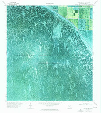 1970 Loxahatchee SE1976 Print · USGSThe northern Everglades take center stage in the 1970s, showing the intersection of managed wetlands and water engineering. Trace the artificial boundary of the L-40 Canal where industrial Pumps manage the flow into Conservation Area No 1.3 unique versions available
 - 1971 Map of Loxahatchee, 1976 Print
 1971 Loxahatchee1976 Print · USGSPalm Beach County’s marshy interior was a land of intensive water management in the early seventies. Genealogists and historians can trace the canals and infrastructure that shaped the area, from the Zoological Garden to the West Palm Beach Canal.
 - 1979 Map of Loxahatchee, 1984 Print
 1979 Loxahatchee1984 Print · USGSPalm Beach County’s western edge in the early eighties shows the complex intersection of large-scale water management and new settlement. Trace the footprint of the Zoological Garden, old navigation channels like the West Palm Beach Canal, and the early layout of Loxahatchee.
End of results
Showing maps 1-3 of 3
Frequently asked questions
- What are the different types of historical maps available for Wellington?
- What is the oldest map of Wellington?
- Where can I purchase historical maps of Wellington for my home or office?
- Where can I download high-res historical maps of Wellington?
- Are there historical topographic maps available for Wellington?
- Is there historical aerial imagery available for Wellington?
- Where are historical maps of Wellington sourced from?