1960s Maps of Pasco County, Florida
Explore 5 historic maps of Pasco County from the 1960s. These maps offer a rare glimpse into what life looked like during the 1960s — showing old roads, neighborhoods, homes, and landmarks that have changed or disappeared over time.
Whether you're researching your family's past, planning a metal detecting trip, or studying how Pasco County's landscape evolved across the 1960s, these high-resolution maps are a powerful tool for exploring the history of this region.
- Focus on a specific era: All maps on this page are from the 1960s, giving you a focused view of this time period.
- See what’s changed: Compare century-old streets, trails, and buildings to today's modern landscape using overlays and satellite layers.
- Research with precision: Use these maps for genealogy, historical research, land use analysis, or educational projects.
- View, download, or print: Maps are fully viewable online in high resolution, and can be downloaded or printed for your own records.
Start exploring Pasco County's history through authentic maps from the 1960s. This is your window into the past.
Pasco County, FL maps
(5)- 1960 Map of Lacoochee
 1960 Lacoochee1960 Print · USGSPasco and Hernando counties centered on the rail-junction towns of the 1960s, where the Withlacoochee River meets a network of citrus-growing ridges. Genealogists can trace family roots at Trilby Cem, Moss Town, and the Old Henley Place.2 unique versions available
 - 1960 Map of Branchborough, 1962 Print
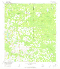
 1960 Branchborough1962 Print · USGSThe swampy interior of Florida at the tri-county border shows a landscape of riverine hammocks and early forest industry in the 1960s. Genealogists and historians can trace the foundations of Branchborough and locate Withlacoochee Cemetery and Port Lonesome.4 unique versions available
 - 1960 Map of Dade City, 1962 Print
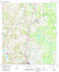
 1960 Dade City1962 Print · USGSPasco County's interior comes into focus during the early 1960s, showing the intersection of Florida's citrus economy and rail history. Trace the old lines of the Atlantic Coast Line to junctions at Vitis or find family history at Mount Zion Cemetery and Tommytown.4 unique versions available
 - 1960 Map of Clay Sink, 1962 Print
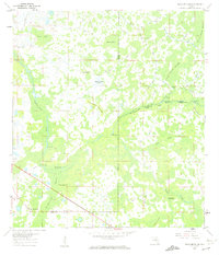
 1960 Clay Sink1962 Print · USGSFlorida's swampy interior at the Hernando and Pasco county line reveals a wilderness of forestry grades and isolated settlements in the early sixties. Researchers can trace the Atlantic Coast Line and locate sites like Bevels Place, Richloam, and Sturkey.2 unique versions available
 - 1964 Map of Plant City
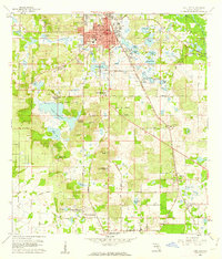
 1964 Plant City1964 Print · USGSThe West Florida coast and its interior rail corridors come alive in this mid-sixties survey, spanning from the gulf marshes to the agricultural heartland. Researchers can trace the routes of the Atlantic Coast Line through settlements like Bushnell, Inverness, and Plant City.
End of results
Showing maps 1-5 of 5
Top cities of Pasco County
- Bayonet Point historical maps
- Holiday historical maps
- Hudson historical maps
- Zephyrhills historical maps
- New Port Richey historical maps
- Elfers historical maps
See more
Frequently asked questions
- What are the different types of historical maps available for Pasco County?
- What is the oldest map of Pasco County?
- Where can I purchase historical maps of Pasco County for my home or office?
- Where can I download high-res historical maps of Pasco County?
- Are there historical topographic maps available for Pasco County?
- Is there historical aerial imagery available for Pasco County?
- Where are historical maps of Pasco County sourced from?