Old Maps of Pasco County, Florida for Hiking & Exploration
Hike through history with 145 historic maps of Pasco County. Explore old trails, ghost towns, and forgotten backroads — perfect for outdoor adventurers and local explorers.
- Rediscover forgotten places: Map out old mining camps, roads, and footpaths that no longer exist on modern maps.
- Layer with modern tools: Combine with LiDAR or satellite views to plan hikes through historical terrain.
- Made for exploration: Popular among hikers, overlanders, and local history lovers.
Use these maps to find adventure and explore the hidden past of Pasco County.
Pasco County, FL maps
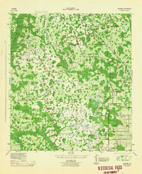
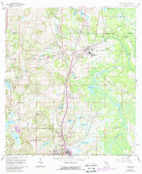
(145)- 1943 Map of Tarpon Springs
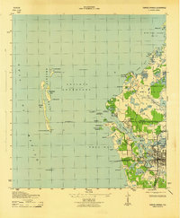 1943 Tarpon Springs1943 Print · USGSThe Gulf coast at the height of the war reveals a maritime landscape centered on the sponge docks and bayous. Researchers can trace the early layout of Tarpon Springs, the historic Anclote Keys Lighthouse, and old landmarks like Baileys Bluff.3 unique versions available
 - 1943 Map of Odessa, 1957 Print
 1943 Odessa1957 Print · USGSCoastal Florida pinelands and transit corridors emerge in this mid-century survey of the Pasco and Hillsborough county line. Trace the steam-era rail history through Odessa at the Atlantic Coast Line junction and explore the lakefronts of Keystone Lake and Camp Mawian.3 unique versions available
 - 1943 Map of Elfers, 1957 Print
 1943 Elfers1957 Print · USGSThe Florida Gulf Coast comes alive in the 1940s as settlements like New Port Richey and Tarpon Springs begin to take shape. Genealogists and researchers can trace the historic Dixie Highway and locate rural landmarks such as Elfers and Seven Springs.2 unique versions available
 - 1943 Map of Lutz, 1961 Print
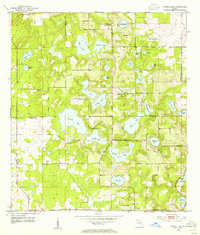
 1943 Lutz1961 Print · USGSThe central Florida lake country comes into focus in the early 1940s as the rail-driven settlements of Lutz and Land O'Lakes began to take shape. Researchers can trace the early layout of Dupree Gardens, local churches like Drexel Ch, and the twin corridors of the Atlantic Coast Line and Seaboard Air Line.2 unique versions available
 - 1944 Map of Wesley Chapel
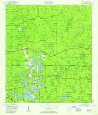
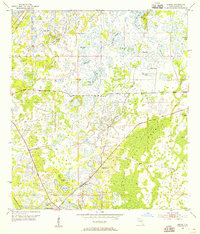
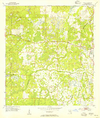
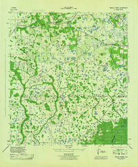 1944 Wesley Chapel1944 Print · USGSPasco and Hillsborough counties are shown during the mid-forties, characterized by scattered rural settlements and a dense network of creeks and cypress swamps. Researchers can trace the original locations of Wesley Chapel, Double Branch Church, and the Sulphur Works along the river banks.3 unique versions available
 - 1944 Map of Elfers
 1944 Elfers1944 Print · USGSThe Florida Gulf coast comes into focus during the mid-1940s as the communities of New Port Richey and Elfers begin to expand. Genealogists and local historians can trace family locations near Seven Springs, the Anclote River, and early rail lines like the Seaboard Air Line.
 - 1944 Map of Lutz
 1944 Lutz1944 Print · USGSFlorida's lake-strewn interior comes alive in the mid-1940s, showing the early rail and road networks of northern Hillsborough County. Genealogists and historians can trace the foundations of Lutz and Drexel, locating essential local landmarks like the Myrtle Denham School and the Drexel Station along the Atlantic Coast Line.
 - 1944 Map of Odessa
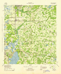
 1944 Odessa1944 Print · USGSMid-century Pasco and Hillsborough counties are shown here as a landscape of citrus groves, rail lines, and cypress swamps. Genealogists and historians can trace the footprint of early communities at Odessa and Lake Fern, or find landmarks like the Lake Fern School and Camp Mawian YMCA.
 - 1944 Map of Socrum
 1944 Socrum1944 Print · USGSCentral Florida's interior at the height of the war era reveals a landscape of citrus groves and cypress swamps at the tri-county corner. Genealogists and historians can trace old homesteads and landmarks like Bethel Church, the settlement of Socrum, and the Atlantic Coast Line tracks.2 unique versions available
 - 1947 Map of Zephyrhills
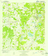
 1947 Zephyrhills1947 Print · USGSPasco County's landscape in the years following the war was a mix of military aviation, rail commerce, and riverfront parkland. Genealogists and local historians can trace the early grids of Zephyrhills, the Zephyrhills Army Air Base, and rural landmarks like the Crystal Springs School.2 unique versions available
 - 1948 Map of Elfers
 1948 Elfers1948 Print · USGSThe Florida Gulf Coast near the Pasco and Pinellas border comes alive in this post-war survey. Genealogists and researchers can trace early settlements at New Port Richey, Elfers, and Seven Springs while following the Seaboard Air Line through the cypress swamps.
 - 1949 Map of Odessa
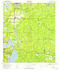
 1949 Odessa1949 Print · USGSThe interior of the Florida Gulf Coast is shown here in the late 1940s, a landscape defined by citrus groves and sprawling lake networks. Genealogists and local historians can trace the early community hubs of Odessa and Lake Fern, including the Lake Fern School and the Atlantic Coast Line rail corridor.
 - 1954 Map of Spring Lake, 1955 Print
 1954 Spring Lake1955 Print · USGSThe Hernando and Pasco county line in the mid-1950s reveals a landscape of high-ground settlements and numerous interior lakes. Genealogists and researchers can locate old landmarks like the Townsend House Cem, Mt Pleasant Ch, and Bay Spring Sch.5 unique versions available
 - 1954 Map of Ehren, 1955 Print
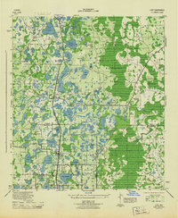
 1954 Ehren1955 Print · USGSIn the mid-1950s, this pocket of Pasco County was a landscape of railroads and wetlands centered on the community of Ehren. Researchers can trace the dual rail lines of the Atlantic Coast Line and locate landmarks like Oak Grove Ch and the Ehren Cem.4 unique versions available
 - 1954 Map of San Antonio, 1955 Print
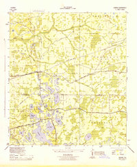
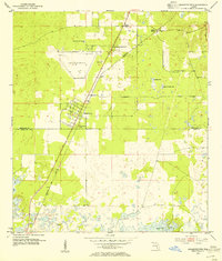
 1954 San Antonio1955 Print · USGSMid-century Pasco County comes into focus in this detailed survey of the citrus and lake country around San Antonio. Genealogists and historians can trace early community hubs like St Leo and Darby, or locate family sites at Holden Cem and Amelia Ch.4 unique versions available
 - 1954 Map of Port Richey, 1955 Print
 1954 Port Richey1955 Print · USGSMid-century Pasco County coastal life is captured here as the towns of Port Richey and New Port Richey began to grow along the Pithlachascotee River. Genealogists and local historians can locate early landmarks such as the Stark Cem, Union Ch, and the Booker T Washington Sch.4 unique versions available
 - 1954 Map of Fivay, 1955 Print
 1954 Fivay1955 Print · USGSMid-century Pasco County remains a landscape of wetlands and small rural outposts in this mid-1950s survey. Researchers can trace the early footprints of Fivay and Gowers Corner alongside the Seaboard Air Line rail and the Fivay Cem.4 unique versions available
 - 1954 Map of Aripeka, 1955 Print
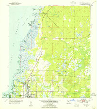
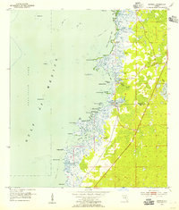 1954 Aripeka1955 Print · USGSThe Aripeka coast in the mid-fifties is a maze of tidal bayous and hammock islands at the county line. Researchers can trace the early layout of Aripeka and find nearby landmarks like Hunters Lake, Bathhouse Island, and the Devils Rock Yard.4 unique versions available
 - 1954 Map of Masaryktown, 1955 Print
 1954 Masaryktown1955 Print · USGSCoastal Hernando and Pasco Counties are captured here in the mid-fifties, centered on the unique immigrant farming colony of Masaryktown. Genealogists and local historians can trace the early layout of Garden Grove, locate the McGeachy Cem, and follow the Seaboard Air Line rail corridor.3 unique versions available
 - 1954 Map of Port Richey NE, 1955 Print
 1954 Port Richey NE1955 Print · USGSThe rural boundary between Hernando and Pasco Counties is shown in the mid-1950s, defined by its unique karst landscape of sinks and wet prairies. Genealogists and local historians can locate Loyce Cem and trace seasonal water bodies like Weekiwachee Prairie Lake or Rock Sink.4 unique versions available
 - 1955 Map of Plant City, 1966 Print
 1955 Plant City1966 Print · USGSMid-century Central Florida comes to life in this survey of the Nature Coast and the inland citrus and rail belt. Genealogists and historians can trace the paths of the Atlantic Coast Line, locate the Anclote Keys Lighthouse, or find old communities like Masaryktown and Lacoochee.6 unique versions available
 - 1958 Map of Plant City
 1958 Plant City1958 Print · USGSFlorida's Gulf Coast and inland ridge country are captured here in the mid-fifties, showing the region before modern sprawl. Genealogists and historians can trace rail-era towns like Richland and Trilby or locate coastal landmarks such as the Anclote Keys Lighthouse.
 - 1959 Map of Plant City
 1959 Plant City1959 Print · USGSThe West Florida coast and inland timberlands are captured here in the late fifties, from the bend of the Gulf to the rail hubs of the interior. Trace the paths of the Atlantic Coast Line through Inverness and find landmarks like the Anclote Keys Lighthouse.
 - 1960 Map of Lacoochee
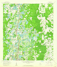
 1960 Lacoochee1960 Print · USGSPasco and Hernando counties centered on the rail-junction towns of the 1960s, where the Withlacoochee River meets a network of citrus-growing ridges. Genealogists can trace family roots at Trilby Cem, Moss Town, and the Old Henley Place.2 unique versions available
 - 1960 Map of Branchborough, 1962 Print
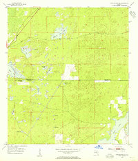
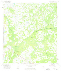 1960 Branchborough1962 Print · USGSThe swampy interior of Florida at the tri-county border shows a landscape of riverine hammocks and early forest industry in the 1960s. Genealogists and historians can trace the foundations of Branchborough and locate Withlacoochee Cemetery and Port Lonesome.4 unique versions available
Showing maps 1-25 of 145
Top cities of Pasco County
- Bayonet Point historical maps
- Holiday historical maps
- Hudson historical maps
- Zephyrhills historical maps
- New Port Richey historical maps
- Elfers historical maps
See more
Frequently asked questions
- What are the different types of historical maps available for Pasco County?
- What is the oldest map of Pasco County?
- Where can I purchase historical maps of Pasco County for my home or office?
- Where can I download high-res historical maps of Pasco County?
- Are there historical topographic maps available for Pasco County?
- Is there historical aerial imagery available for Pasco County?
- Where are historical maps of Pasco County sourced from?