Old Maps of Safety Harbor, Pinellas County
Explore 21 old maps of Safety Harbor, spanning from 1921 to today. These high-resolution historic maps reveal how streets, neighborhoods, landmarks, and natural features evolved over time — perfect for genealogy, metal detecting, research, and local history exploration.
What you can do with these maps:
- See how Safety Harbor changed over time: Compare historical maps to modern-day views to trace roads, homesites, rail lines & more.
- View detailed metadata: Each map includes creators, publishers, year, scale, and archive source.
- Overlay maps with satellite & LiDAR: Visualize the past alongside modern tools to explore terrain & human change.
- Trusted historical sources: Maps sourced from the USGS, Library of Congress, and other archives.
- Access maps your way: View online, download high-res files, or order prints for personal or research use.
Start exploring old maps of Safety Harbor to uncover forgotten places, hidden landmarks, and the deep history beneath your feet.
Safety Harbor, Pinellas County maps
(21)- 1921 Map of St Petersburg
 1921 St Petersburg1921 Print · USGSCovers Safety Harbor, including Tampa, Saint Petersburg, and other nearby areas2 unique versions available
 - 1943 Map of Safety Harbor
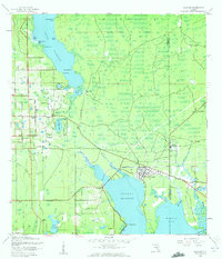
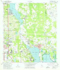
 1943 Safety Harbor1943 Print · USGSCovers Safety Harbor, including Saint Petersburg, Clearwater, and other nearby areas
 - 1943 Map of Oldsmar, 1961 Print
 1943 Oldsmar1961 Print · USGSCovers Safety Harbor, including Clearwater, East Lake, and other nearby areas2 unique versions available
 - 1944 Map of Oldsmar
 1944 Oldsmar1944 Print · USGSCovers Safety Harbor, including Clearwater, East Lake, and other nearby areas
 - 1947 Map of Safety Harbor, 1952 Print
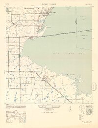 1947 Safety Harbor1952 Print · USGSCovers Safety Harbor, including Saint Petersburg, Clearwater, and other nearby areas2 unique versions available
 - 1952 Map of Safety Harbor
 1952 Safety Harbor1952 Print · USGSCovers Safety Harbor, including Saint Petersburg, Clearwater, and other nearby areas
 - 1955 Map of Plant City, 1966 Print
 1955 Plant City1966 Print · USGSCovers Safety Harbor, including Tampa, Lakeland, and other nearby areas6 unique versions available
 - 1956 Map of Safety Harbor, 1957 Print
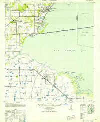
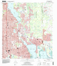
 1956 Safety Harbor1957 Print · USGSCovers Safety Harbor, including Saint Petersburg, Clearwater, and other nearby areas5 unique versions available
 - 1956 Map of Tampa, 1964 Print
 1956 Tampa1964 Print · USGSCovers Safety Harbor, including Tampa, Saint Petersburg, and other nearby areas2 unique versions available
 - 1958 Map of Plant City
 1958 Plant City1958 Print · USGSCovers Safety Harbor, including Tampa, Lakeland, and other nearby areas
 - 1959 Map of Plant City
 1959 Plant City1959 Print · USGSCovers Safety Harbor, including Tampa, Lakeland, and other nearby areas
 - 1959 Map of Tampa
 1959 Tampa1959 Print · USGSCovers Safety Harbor, including Tampa, Saint Petersburg, and other nearby areas
 - 1960 Map of Tampa
 1960 Tampa1960 Print · USGSCovers Safety Harbor, including Tampa, Saint Petersburg, and other nearby areas2 unique versions available
 - 1964 Map of Plant City
 1964 Plant City1964 Print · USGSCovers Safety Harbor, including Tampa, Lakeland, and other nearby areas
 - 1972 Map of Tampa, 1974 Print
 1972 Tampa1974 Print · USGSCovers Safety Harbor, including Tampa, Saint Petersburg, and other nearby areas
 - 1974 Map of Oldsmar, 1976 Print
 1974 Oldsmar1976 Print · USGSCovers Safety Harbor, including Clearwater, East Lake, and other nearby areas2 unique versions available
 - 1978 Map of Tarpon Springs, 1982 Print
 1978 Tarpon Springs1982 Print · USGSCovers Safety Harbor, including Tampa, Lakeland, and other nearby areas2 unique versions available
 - 1981 Map of St Petersburg, 1983 Print
 1981 St Petersburg1983 Print · USGSCovers Safety Harbor, including Tampa, Saint Petersburg, and other nearby areas
 - 1988 Map of St Petersburg
 1988 St Petersburg1988 Print · USGSCovers Safety Harbor, including Tampa, Saint Petersburg, and other nearby areas
 - 1995 Map of Oldsmar, 2000 Print
 1995 Oldsmar2000 Print · USGSCovers Safety Harbor, including Clearwater, East Lake, and other nearby areas
 - 1998 Map of Safety Harbor, 2001 Print
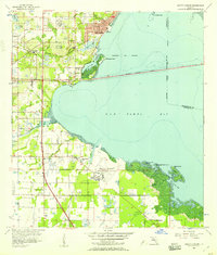
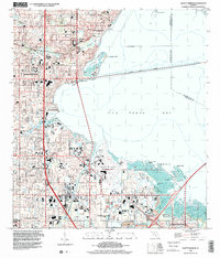 1998 Safety Harbor2001 Print · USGSCovers Safety Harbor, including Saint Petersburg, Clearwater, and other nearby areas
End of results
Showing maps 1-21 of 21
Frequently asked questions
- What are the different types of historical maps available for Safety Harbor?
- What is the oldest map of Safety Harbor?
- Where can I purchase historical maps of Safety Harbor for my home or office?
- Where can I download high-res historical maps of Safety Harbor?
- Are there historical topographic maps available for Safety Harbor?
- Is there historical aerial imagery available for Safety Harbor?
- Where are historical maps of Safety Harbor sourced from?