1940s Maps of Putnam County, Florida
Explore 15 historic maps of Putnam County from the 1940s. These maps offer a rare glimpse into what life looked like during the 1940s — showing old roads, neighborhoods, homes, and landmarks that have changed or disappeared over time.
Whether you're researching your family's past, planning a metal detecting trip, or studying how Putnam County's landscape evolved across the 1940s, these high-resolution maps are a powerful tool for exploring the history of this region.
- Focus on a specific era: All maps on this page are from the 1940s, giving you a focused view of this time period.
- See what’s changed: Compare century-old streets, trails, and buildings to today's modern landscape using overlays and satellite layers.
- Research with precision: Use these maps for genealogy, historical research, land use analysis, or educational projects.
- View, download, or print: Maps are fully viewable online in high resolution, and can be downloaded or printed for your own records.
Start exploring Putnam County's history through authentic maps from the 1940s. This is your window into the past.
Putnam County, FL maps
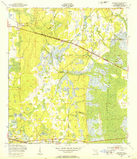
(15)- 1942 Map of Ates Creek
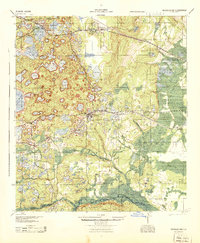
 1942 Ates Creek1942 Print · USGSNorthern Florida's training grounds and rural settlements come into focus during the early mobilization of the Second World War. Researchers can trace the military layout of Camp Blanding alongside the agricultural colony at Penney Farms and the springs of Gold Head Branch.
 - 1943 Map of Hawthorn, 1963 Print
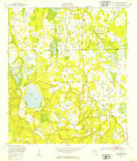
 1943 Hawthorn1963 Print · USGSAlachua County during the early war years reveals a landscape defined by its great lakes and a dual-railroad economy. Researchers can trace the routes of the Seaboard Air Line, locate rural landmarks like Ochwilla Church, or find family roots at Providence Cem and Drummond Cem.
 - 1944 Map of Interlachen
 1944 Interlachen1944 Print · USGSNorth-central Florida's rail-and-water network is captured here in the 1940s, centered on the bustling junction at Interlachen. Genealogists and historians can trace riverside activity at Cedar Landing Ferry and early rural education sites like Congo Sch.
 - 1947 Map of Bostwick
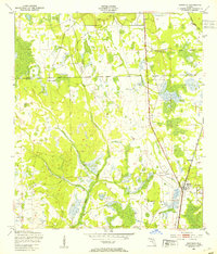
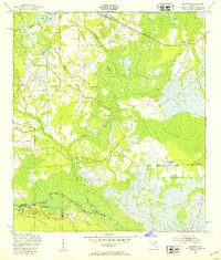
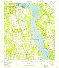
 1947 Bostwick1947 Print · USGSThe Saint Johns River valley in the late 1940s reveals a landscape defined by its waterways and timber-era rail lines. Researchers can trace historic river access at Clay Landing and Picolata, or follow the Atlantic Coast Line through Bostwick.
 - 1949 Map of Rice Creek, 1953 Print
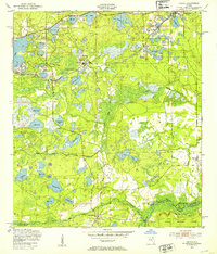
 1949 Rice Creek1953 Print · USGSIn the late 1940s, the borderlands between Clay and Putnam Counties remained a dense mosaic of wetlands and winding waterways. Researchers can trace the pristine hydrology of the region through Georges Lake and the paths of Etonia Creek and Rice Creek.3 unique versions available
 - 1949 Map of Bostwick, 1953 Print
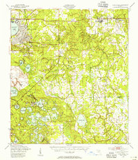
 1949 Bostwick1953 Print · USGSNorthern Putnam County's rural landscape is captured here in the late forties, showing the region's timber and rail-based settlement pattern. Genealogists can trace family locations near Sun Garden, Hancock, and De Coy Ch, or locate the old Bostwick Airport.5 unique versions available
 - 1949 Map of Keuka, 1953 Print
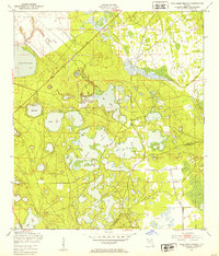
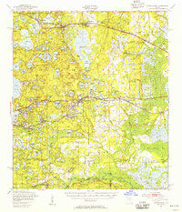
 1949 Keuka1953 Print · USGSFlorida's lake country near the Marion and Putnam county line was a network of river landings and rail stops in the late 1940s. Genealogists and historians can trace community roots at Edgar Community Ch, find old crossings like Brumbridge Ferry, and locate early riverfront points at Agnews Landing.6 unique versions available
 - 1949 Map of Baywood, 1953 Print
 1949 Baywood1953 Print · USGSPutnam County in the late 1940s reveals a Florida landscape of cypress swamps and railway settlements. Researchers can trace family history at Mannville Cem or locate the early industry of Peat Cuttings near the Southern and Atlantic Coast Line railroads.3 unique versions available
 - 1949 Map of Rodman, 1953 Print
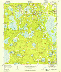
 1949 Rodman1953 Print · USGSInland Florida in the late 1940s was a land of timber mills and riverfront landings. Trace the early boundaries of the Ocala National Forest and locate historical sites like Rainbow Ranch, Rodman, and the riverside Cedar Landing.3 unique versions available
 - 1949 Map of Gold Head Branch, 1953 Print
 1949 Gold Head Branch1953 Print · USGSThe solution-lake country of North Florida is captured here just after the war, showing the intersection of rural life and state-protected wilderness. Researchers can trace the boundaries of Gold Head Branch State Park or locate the Cadero Ch and the Mobile Target Range.3 unique versions available
 - 1949 Map of Putnam Hall, 1953 Print
 1949 Putnam Hall1953 Print · USGSThe lake-strewn interior of Putnam and Clay counties is captured here in the late 1940s, highlighting a landscape of rail-connected settlements. Genealogists and researchers can trace old trackside communities like Florahome, Putnam Hall, and Grandin along the Southern railroad line.3 unique versions available
 - 1949 Map of Riverdale, 1953 Print
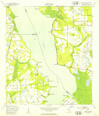 1949 Riverdale1953 Print · USGSThe St. Johns River corridor comes alive in the late 1940s, showing the intersection of three counties and the riverfront communities that thrived there. Genealogists and historians can trace old landings and rail stops like West Tocoi, Federal Point, and the station at Riverdale.4 unique versions available
 - 1949 Map of Ates Creek, 1955 Print
 1949 Ates Creek1955 Print · USGSClay County during the post-war era shows a landscape transitioning between military readiness and civilian growth. Researchers can locate the sprawling Camp Blanding facilities, the planned community of Penney Farms, and historic sites like Beulah Cem.2 unique versions available
 - 1949 Map of Interlachen, 1955 Print
 1949 Interlachen1955 Print · USGSPutnam County's lake-rich interior is captured here just after the war, showing the distinct citrus and rail-centered settlements of the era. Genealogists can locate family landmarks like Mt Bethel Ch, Johnson Park Sch, and the unique Peat Cuttings near Florahome.3 unique versions available
 - 1949 Map of Bostwick, 1955 Print
 1949 Bostwick1955 Print · USGSThe St. Johns River corridor comes to life in the late 1940s, showing a landscape of military installations and quiet river landings. Researchers can trace family roots at Shiloh Ch or Bostwick, and locate vanished river hubs like Picolata and Tocoi.
End of results
Showing maps 1-15 of 15
Top cities of Putnam County
- Palatka historical maps
- Crescent City historical maps
- Interlachen historical maps
- Pomona Park historical maps
- Welaka historical maps
Frequently asked questions
- What are the different types of historical maps available for Putnam County?
- What is the oldest map of Putnam County?
- Where can I purchase historical maps of Putnam County for my home or office?
- Where can I download high-res historical maps of Putnam County?
- Are there historical topographic maps available for Putnam County?
- Is there historical aerial imagery available for Putnam County?
- Where are historical maps of Putnam County sourced from?