1990s Maps of Putnam County, Florida
Explore 11 historic maps of Putnam County from the 1990s. These maps offer a rare glimpse into what life looked like during the 1990s — showing old roads, neighborhoods, homes, and landmarks that have changed or disappeared over time.
Whether you're researching your family's past, planning a metal detecting trip, or studying how Putnam County's landscape evolved across the 1990s, these high-resolution maps are a powerful tool for exploring the history of this region.
- Focus on a specific era: All maps on this page are from the 1990s, giving you a focused view of this time period.
- See what’s changed: Compare century-old streets, trails, and buildings to today's modern landscape using overlays and satellite layers.
- Research with precision: Use these maps for genealogy, historical research, land use analysis, or educational projects.
- View, download, or print: Maps are fully viewable online in high resolution, and can be downloaded or printed for your own records.
Start exploring Putnam County's history through authentic maps from the 1990s. This is your window into the past.
Putnam County, FL maps
(11)- 1991 Map of Riverdale
 1991 Riverdale1991 Print · USGSThe St. Johns River corridor comes alive in the early nineties, documenting the riverside landings and crossings that shaped this region. Researchers can trace family sites near Riverdale, Federal Point, and St Johns Ch, or follow the Old Railroad Grade.
 - 1991 Map of Bostwick
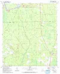 1991 Bostwick1991 Print · USGSThe Florida borderlands of Clay and Putnam Counties come into focus in the early nineties, revealing a landscape of rural settlements and industry. Genealogists and historians can trace the foundations of Bostwick and Sun Garden, while finding landmarks like DeCoy Ch and the Lookout Tower.
 - 1993 Map of Gold Head Branch
 1993 Gold Head Branch1993 Print · USGSFlorida's northern lake country is shown in the early nineties, centered on the protected lands of Clay County. Genealogists and local historians can locate early burial sites at Gadara Cem and trace the rural paths of Bellamy Road near Hall Lake.
 - 1993 Map of Baywood
 1993 Baywood1993 Print · USGSIn the early nineties, this northern Florida region shows a landscape of interconnected wetlands and small rural outposts like Baywood and Carraway. Genealogists can locate family landmarks such as Naomi Ch, Pine Lawn Cem, and the path of the Old RR Grade.
 - 1993 Map of Rodman
 1993 Rodman1993 Print · USGSThis part of Putnam County in the early 1990s shows a landscape shaped by the Cross Florida Barge Canal project and the Ocala National Forest. Researchers can trace the Old Railroad Grade or locate family sites like the King-Strickland-Walker Cem and Cedar Landing.
 - 1993 Map of Putnam Hall
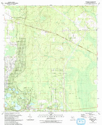
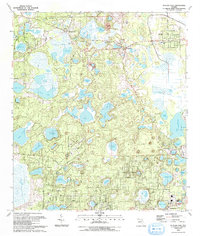 1993 Putnam Hall1993 Print · USGSFlorida’s lake country near the Clay County line is shown here in the early nineties, featuring a landscape of dense water bodies and growing rural communities. Genealogists and local historians can trace the roads of Florahome, locate the Paran Ch & Cem, or explore the lakeside grids of Interlachen.
 - 1993 Map of Rice Creek
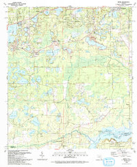
 1993 Rice Creek1993 Print · USGSFlorida's wet lowlands along the Clay and Putnam county line are captured here in the early nineties, centered on the community of Harlem. Genealogists and researchers can trace family landmarks like Mt Hebron Cem, Union Grove Cem, and Providence Ch.
 - 1993 Map of Keuka
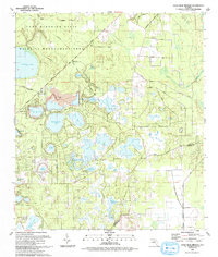
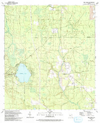
 1993 Keuka1993 Print · USGSPutnam County's lake-strewn landscape is captured here in the early nineties, showing the intersection of small-town life and the edge of the Ocala National Forest. You can trace historical rural landmarks from Fort Brook Landing on the river to old spiritual centers like Mt Bethel Ch and Magnolia Church.
 - 1994 Map of Crescent City, 1998 Print
 1994 Crescent City1998 Print · USGSCrescent City and its neighboring citrus settlements are captured in the late twentieth century, before modern development further altered the lake-strewn landscape. Researchers can trace family roots through Pomona-Lake Como Cem or locate the old Crescent City Station and Thunderbird Airpark.
 - 1994 Map of Welaka, 1998 Print
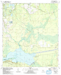
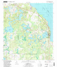
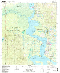 1994 Welaka1998 Print · USGSThe St. Johns riverfront and the northern reaches of Lake George come into focus in this late-twentieth-century study of Putnam County. Genealogists and local researchers can trace old river landings and settlements like Welaka, Norwalk, and the expansive Drayton Island.
 - 1994 Map of Salt Springs, 1998 Print
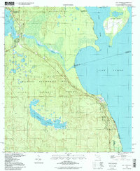 1994 Salt Springs1998 Print · USGSFlorida's riverine borderlands are detailed here in the 1990s, where the St Johns River meets the vast freshwater expanse of Lake George. Trace the waterways from Salt Springs to the marshy reaches of Hopkins Prairie or the shores of Drayton Island.
End of results
Showing maps 1-11 of 11
Top cities of Putnam County
- Palatka historical maps
- Crescent City historical maps
- Interlachen historical maps
- Pomona Park historical maps
- Welaka historical maps
Frequently asked questions
- What are the different types of historical maps available for Putnam County?
- What is the oldest map of Putnam County?
- Where can I purchase historical maps of Putnam County for my home or office?
- Where can I download high-res historical maps of Putnam County?
- Are there historical topographic maps available for Putnam County?
- Is there historical aerial imagery available for Putnam County?
- Where are historical maps of Putnam County sourced from?